
Chaffee County Road 101County Road 49 Closed
Related Incident:
Publication Type: Closures
Chaffee County Road 101/County Road 49 (Bear Creek Road) in Fremont County is closed due to fire operations. Local traffic only is allowed.
Actualizacin del incendio Decker 28 de septiembre 2019 1000am
Related Incident:
Publication Type: News
Más recursos llegan en preparación para las condiciones de Bandera Roja
Situación actual: Los bomberos aprovecharon del leve ayer, reforzando la línea de fuego y explorando oportunidades para acorralar el incendio en la tierra salvaje. Las tripulaciones trabajaron para completar la línea de fuego indirecta en el lado oeste del incendio desde la cicatriz del incendio de Ox Cart hasta la carretera 990. El helicóptero K-MAX ayudó a los bomberos a reducir la velocidad del incendio, que se extendió hasta al drenaje de Bear Creek
Hoy llegan recursos adicionales en previsión de la Advertencia de Bandera Roja emitida para el domingo y el lunes. Las tripulaciones comenzarán a ayudar a los propietarios con la mitigación de combustible en el vecindario de Bear Creek. Las acciones de mitigación incluyen las ramas de las extremidades, el recorte de la vegetación y el establecimiento de sistemas temporales de aspersores. Varios vehículos contra incendio también estarán patrullando en la zona. Estas medidas de precaución crearán un espacio más defendible en este barrio.
Si las condiciones lo permiten, esta mañana puede producirse una operación de ignición aérea planificada en las elevaciones más altas del Bosque Nacional del Río Grande. Esta operación conectará el fuego activo a la cicatriz del incendio de Ox Cart de 2013 para ayudar a asegurar el parámetro sur.
Los recursos aéreos volverán a ser visibles hoy cerca del Rainbow Trail. Las tripulaciones extenderán la línea de fuego hacia el sur, desde Rainbow Trail hasta las formaciones naturales de piedra que está cerca del borde del incendio. Esto reducirá el potencial de propagación de fuego en el drenaje de Bear Creek.
El bosque nacional estima que las áreas dentro de la sierra de Sangre de Cristo tienen hasta un 80% de mortalidad de árboles de ataque de escarabajas y caídas de árboles. El incendio Decker está gestionando parar eliminar estos combustibles de alto riesgo del medioambiente para beneficio ecológico y para reducir el riesgo de incendios forestales catastróficos en el futuro.
El incendio puede ser visible en la noche de los corredores de carreteras 50 y 285. Se pide a motoristas que no paran en la calzada y que estar libre de la calzada antes de observar el incendio. Favor de no llamar al 911 para reportar comportamiento del incendio o pedir información del incendio Decker. Hay una línea disponible para novedades del incendio. El 911 es solo para emergencias.
Condiciones climáticas y de combustibles: Se espera que las temperaturas alcancen los 70 grados con una humedad del 20-25 por ciento. Después de las 10 de la mañana, los vientos estarán fuera del suroeste a 15-20 mph con ráfagas de hasta 35 mph. Las condiciones deben permanecer moderadas hoy debido al aumento de la humedad. El domingo, el aire más seco se traslada a la región, lo que lleva a las condiciones climáticas críticas esperadas del fuego. Se ha emitido una Advertencia de Bandera Roja para el domingo y el lunes
Evacuaciones y cierres: Partes de caminos 101 y 101A en el bosque nacional y el Rainbow Trail (camino 1336) sur de camino 108 hacia el Stout Lakes Trail están cerrados. Se ha emitido una restricción de vuelo temporal (TRF) en el área sobre el incendio a permitir operaciones aéreas. Recuerda: si no es permitido que vuelen, tampoco podemos volar nosotros. No hay evacuaciones en este tiempo. Humo puede asentarse en el corredor de carretera 50 en la tarde o noche. Se alienta a los conductores a reducir la velocidad cerca de fuego si el humo afecta la visibilidad.
Humo: Actualizaciones de humo son disponible en bit.ly/deckerfiresmoke. El pronóstico se puede encontrar a https://wildlandfiresmoke.net/outlooks/CentralColorado.
Estadísticas del incendio Decker:
Tamaño: 1374 acres
Total de personal: 140
Causa: relámpago
Fecha de inicio: 8 de septiembre 2019
Locación: 9 millas sur de Salida, CO
Información de contacto:
Línea de información del incendio en inglés: (719) 626-1095 (8am-8pm)
Email: 2019.Decker@firenet.gov
InciWeb: inciweb.ncwg.gov/incident/6592
Facebook: Facebook.com/DeckerFire2019
*Translated by Elena A. Jimenez
More Resources Arrive in Preparation for Red Flag Conditions
Related Incident:
Publication Type: News
Decker Fire Update
September 28, 2019, 10:00 a.m.
Rio Grande National Forest
Pike-San Isabel National Forest
BLM - Front Range Fire and Aviation Management Unit
Justin Yankey, Incident Commander
More Resources Arrive in Preparation for Red Flag Conditions
Current Situation: Firefighters took advantage of mild fire behavior yesterday, reinforcing fireline and scouting for opportunities to corral the fire in the Wilderness. Crews worked to complete indirect fire line on the west side of the fire from Ox Cart Fire scar to road 990. The K-MAX helicopter assisted firefighters in slowing fire spread into the Bear Creek drainage.
In anticipation of the Red Flag Warning issued for Sunday and Monday, additional resources will arrive today. Crews will begin assisting homeowners with fuel mitigation in the Bear Creek neighborhood. Mitigation actions include limbing branches, trimming vegetation and establishing temporary sprinkler systems. Several engines will be on patrol in the area as well. These precautionary measures will create more defensible space in this neighborhood.
If conditions allow, a planned aerial ignition operation may occur this morning in the higher elevations on the Rio Grande National Forest. This operation will connect the active fire into the 2013 Ox Cart Fire burn scar to help secure the southern parameter.
Aerial resources will be visible again today near the Rainbow Trail. Crews will be extending fireline south from the Rainbow Trail into natural rock features near the fire’s edge. This will reduce the potential of fire spread into the Bear Creek drainage.
The U.S. Forest Service estimates the Sangre De Cristo Wilderness has up to 80% tree mortality from beetle-kill and blowdown. The Decker Fire is being managed to remove these high-risk fuels from the landscape, reduce future risk and restore ecological balance to the forest.
The fire may be visible from both the US 50 and US 285 corridors. Motorists are asked to not stop in the roadway and be clear of the roadway before stopping to observe the fire. Please do not call 911 to report fire behavior on the Decker Fire or to request fire information. A fire information line is available for fire updates. Please call 911 for emergencies only.
Weather & Fuel Conditions: Temperatures are expected to reach 70 degrees with humidity at 20-25 percent. After 10 am, winds will be out of the southwest at 15-20 mph with gusts up to 35 mph. Conditions should remain moderate today due to the increased humidity. Sunday, drier air moves into the region, leading to expected critical fire weather conditions. A Red Flag Warning has been issued for Sunday and Monday
Closures: Portions of the 101 and 101A roads on National Forest lands and the Rainbow Trail (1336 tail) south of 108 road to the Stout Lakes Trail (1403 trail) have been closed. A temporary flight restriction (TFR) has been issued over the fire area to allow for aerial operations. Remember: if you fly, we can’t. There are no evacuations at this time. Smoke may settle into the US Highway 50 corridor in the late afternoons or evenings. Drivers are encouraged to reduce speed near the fire if smoke impacts visibility.
Smoke: Real-time smoke information is available at bit.ly/deckerfiresmokeinfo. Today’s smoke forecast for Salida and Arkansas River Valley is available at https://wildlandfiresmoke.net/outlooks/CentralColorado.
Decker Fire Statistics:
Size: 1374 acres
Total Personnel: 140
Cause: Lightning
Start Date: September 8, 2019
Location: 9 miles south of Salida, CO
Contact Information:
InciWeb: https://inciweb.nwcg.gov/incident/6592/
Facebook: facebook.com/DeckerFire2019
Twitter: #DeckerFire2019
Fire Info Line: (719) 626-1095 (8 a.m. to 8 p.m.)
Email: 2019.Decker@firenet.gov
Actualizacin del incendio Decker 27 de septiembre 2019 1000am
Related Incident:
Publication Type: News
Las nubes de la tarde moderarán el comportamiento del fuego hoy
Situación actual: Como se esperaba ayer, la combinación de la alineación del viento, el terreno y la luz solar directa resultó en aumentar la intensidad del incendio en el pico de Simmons en la zona de drenaje de Bear Creek superior. El fuego permaneció en la misma trayectoria con algunas secciones uniéndose, quemando sobre sí misma en unos lugares. El incendio no alcanzó los Puntos de acción de gestión (MAP) del Rainbow Trail. Los MAP son puntos geográficos en el mapa donde, si el incendio los alcanza, se implementará un plan predeterminado. Los equipos reforzaron las líneas indirectas en todas las partes del fuego para cumplir con el objetivo de prevenir la propagación del incendio desde la tierra salvaje.
Los bomberos continuarán construyendo una línea de mano indirecta utilizando características existentes como carreteras, drenajes húmedos y senderos desde la cicatriz de incendios de Ox Cart hasta Round Hill Trail para mantener el fuego fuera de la tierra privada y BLM. Mientras lleguen más tripulaciones, se explorarán la cordillera al sur de Sand Creek en busca de oportunidades para construir la línea. Las tripulaciones en el lado este del fuego atacarán el incendio donde sea seguro hacerlo mientas el incendio retrocede hacia el Rainbow Trail. Los drenajes húmedos y Rainbow Trail se utilizarán para acorralar el incendio.
Los recursos permanecen reposicionados antes de un posible aumento de la actividad en contra de los incendios. Esta es una medida proactiva para garantizar la seguridad pública y de los bomberos. Los recursos aéreos estarán disponibles hoy para ayudar a los recursos terrestres si es necesario. Un avión de ala fija volará por encima del fuego hoy para apoyar a los bomberos.
Los cielos parcialmente nublados, las temperaturas más frías, y la humedad un poco más alta, ayudarán a moderar el comportamiento del incendio. Los vientos tendrán menos efecto en el fuego hoy, sin embargo tormentas aisladas pueden ocurrir después de las 12 p.m. con lluvias dispersas después de las 2 p.m. Las tormentas traerán vientos de salida erráticos y ráfagas que pueden afectar el comportamiento del incendio.
El bosque nacional estima que las áreas dentro de la sierra de Sangre de Cristo tienen hasta un 80% de mortalidad de árboles de ataque de escarabajas y caídas de árboles. El incendio Decker está gestionando parar eliminar estos combustibles de alto riesgo del medioambiente para beneficio ecológico y para reducir el riesgo de incendios forestales catastróficos en el futuro.
El incendio puede ser visible en la noche de los corredores de carreteras 50 y 285. Se pide a motoristas que no paran en la calzada y que estar libre de la calzada antes de observar el incendio. Favor de no llamar al 911 para reportar comportamiento del incendio o pedir información del incendio Decker. Hay una línea disponible para novedades del incendio. El 911 es solo para emergencias.
Condiciones climáticas y de combustibles: Se espera que el tiempo aumenta 62 grados con un nivel de humedad de 23-32 por ciento. Vientos serán del oeste de 13-17 mph con ráfagas de 28 mph. Los vientos moverán suroeste en la tarde. De domingo a miércoles se espera un período prolongado de condiciones ventosas y secas del suroeste, posiblemente llevando humo a la zona de Salida.
Evacuaciones y cierres: Partes de caminos 101 y 101A en el bosque nacional y el Rainbow Trail (camino 1336) sur de camino 108 hacia el Stout Lakes Trail están cerrados. Se ha emitido una restricción de vuelo temporal (TRF) en el área sobre el incendio a permitir operaciones aéreas. Recuerda: si no es permitido que vuelen, tampoco podemos volar nosotros. No hay evacuaciones en este tiempo. Humo puede asentarse en el corredor de carretera 50 en la tarde o noche. Se alienta a los conductores a reducir la velocidad cerca de fuego si el humo afecta la visibilidad.
Humo: Actualizaciones de humo son disponible en bit.ly/deckerfiresmoke. El pronóstico se puede encontrar a https://wildlandfiresmoke.net/outlooks/CentralColorado.
Estadísticas del incendio Decker:
Tamaño: 1334 acres
Total de personal: 118
Causa: relámpago
Fecha de inicio: 8 de septiembre 2019
Locación: 9 millas sur de Salida, CO
Información de contacto:
Línea de información del incendio en inglés: (719) 626-1095 (8am-8pm)
Email: 2019.Decker@firenet.gov
InciWeb: inciweb.ncwg.gov/incident/6592
Facebook: Facebook.com/DeckerFire2019
*Translated by Elena A. Jimenez
Afternoon Clouds Expected to Moderate Fire Behavior Today
Related Incident:
Publication Type: News
Decker Fire Update
September 27, 2019, 10:00 a.m.
Rio Grande National Forest
Pike-San Isabel National Forest
BLM - Front Range Fire and Aviation Management Unit
Justin Yankey, Incident Commander
Afternoon Clouds Expected to Moderate Fire Behavior Today
Current Situation: As expected yesterday, the alignment of wind, terrain and direct sunlight resulted in increased fire activity high on Simmons Peak in upper Bear Creek Drainage. The fire remained in the previous footprint and sections grew together burning back on itself in some places. Management Action Points (MAP) were not reached along the Rainbow Trail. MAPs are geographic points on the map where if reached by the fire a predetermined plan will be implemented. Crews reinforced indirect lines on all portions of the fire to meet the objective of preventing fire spread from the Wilderness.
Firefighters will continue to construct indirect hand line using existing features such as roads, wet drainages and trails from the Ox Cart fire scar to Round Hill Trail to keep fire off private and BLM land. As more crews arrive, they will scout the ridgeline south of Sand Creek for opportunities to construct line. Crews on the east side of the fire will engage the fire where safe to do so as it backs towards the Rainbow Trail. Wet drainages and Rainbow Trail will be utilized to corral the fire.
Resources remain prepositioned in advance of a potential increase in fire activity. This is a proactive measure to ensure public and firefighters safety. Aerial resources will be available today to assist ground resources if required. A fixed wing aircraft will be flying above the fire today to support firefighters with an extra eye in the sky.
Partly cloudy skies, cooler temperatures and slightly higher relative humidity will moderate fire behavior. Winds will have less of an effect on the fire today, however isolated thunderstorms may occur after 12 p.m. with scattered showers after 2 p.m. Thunderstorms will bring erratic and gusty outflow winds that may impact fire behavior.
The U.S. Forest Service estimates the Sangre De Cristo Wilderness has up to 80% tree mortality from beetle-kill and blowdown. The Decker Fire is being managed to remove these high-risk fuels from the landscape, reduce future risk and restore ecological balance to the forest.
The fire may be visible from both the US 50 and US 285 corridors. Motorists are asked to not stop in the roadway and be clear of the roadway before stopping to observe the fire. Please do not call 911 to report fire behavior on the Decker Fire or to request fire information. A fire information line is available for fire updates. Please call 911 for emergencies only.
Weather & Fuel Conditions: Temperatures are expected to reach 62 degrees with humidity at 23-32 percent. Winds will be out of the west at 13-17 mph with gusts up to 28 mph. Winds will shift southwest late evening. A prolonged period of southwest windy and dry conditions are expected Sunday through Wednesday, possibly bringing smoke to the Salida area.
Closures: Portions of the 101 and 101A roads on National Forest lands and the Rainbow Trail (1336 tail) south of 108 road to the Stout Lakes Trail (1403 trail) have been closed. A temporary flight restriction (TFR) has been issued over the fire area to allow for aerial operations. Remember: if you fly, we can’t. There are no evacuations at this time. Smoke may settle into the US Highway 50 corridor in the late afternoons or evenings. Drivers are encouraged to reduce speed near the fire if smoke affects visibility.
Smoke: Real-time smoke information is available at bit.ly/deckerfiresmokeinfo. Today’s smoke forecast for Salida and Arkansas River Valley is available at https://wildlandfiresmoke.net/outlooks/CentralColorado.
Decker Fire Statistics:
Contact Information:
Size: 1334 acres
InciWeb: https://inciweb.nwcg.gov/incident/6592/
Total Personnel: 118
Facebook: facebook.com/DeckerFire2019
Cause: Lightning
Twitter: #DeckerFire2019
Start Date: September 8, 2019
Fire Info Line: (719) 626-1095 (8 a.m. to 8 p.m.)
Location: 9 miles south of Salida, CO
Email: 2019.Decker@firenet.gov
Gusty Winds May Increase Fire Behavior Today
Related Incident:
Publication Type: News
Decker Fire Update
September 26, 2019, 10:00 a.m.
Rio Grande National Forest
Pike-San Isabel National Forest
BLM - Front Range Fire and Aviation Management Unit
Justin Yankey, Incident Commander
Gusty Winds May Increase Fire Behavior Today
Current Situation: Growth was minimal on the fire yesterday. On the west side crews utilized Round Hill Trail and two-track roads to check the fire from advancing north. The active fire on Simmons Peak continued to slowly back down towards the Rainbow Trail into drainages, burning out interior pockets of dead and down timber. Crews are clearing the section of line near the intersection of the 101 road and the Rainbow Trail. These actions are to meet the incident’s objective of keeping the fire in the Wilderness.
Today the Teton Wildland Fire Module and Juniper Valley hand crew will prep indirect line moving northwest to keep fire off private and BLM on the west side. They will also scout for opportunities to use natural and existing control features. On the east side Alpine Hotshots will monitor fire spread towards the Rainbow Trail and implement firing operations if necessary. Pike Hotshots and Wind Cave Engine 629 will also scout options for direct line to tie fire into a southern wet drainage of Bear Creek.
The U.S. Forest Service estimates the Sangre De Cristo Wilderness has up to 80% tree mortality from beetle-kill and blowdown. The Decker Fire is removing high-risk fuels from the landscape, reducing future risk and restoring ecological balance to the forest.
Due to steep inaccessible terrain and heavy fuels we will continue to provide for our firefighter's safety by engaging directly with the fire where the probability of success is high and firefighter exposure is minimized.
Mostly sunny skies, unseasonable warm temperatures and low relative humidity are expected today. Winds will be the main factor today with southwest winds increasing by mid-morning with gust up to 39 mph. There is a chance of isolated thunderstorms after 1:00 p.m. which could bring erratic and gusty outflow winds and lightning to the fire area.
The fire may be visible from both the US 50 and US 285 corridors. Motorists are asked to not stop in the roadway and be clear of the roadway before stopping to observe the fire. Please do not call 911 to report fire behavior on the Decker Fire or to request fire information. A fire information line is available for fire updates. Please call 911 for emergencies only.
Weather & Fuel Conditions: Temperatures are expected to reach 70 degrees with humidity at 15-20 percent. Winds will be out of the southwest at 20-25 mph with gust up to 38 mph. Winds will shift west late afternoon and weaken slightly. Winds will remain elevated overnight. Dry weather with unseasonably warm temperatures are likely through to next week.
Evacuations and Closures: Portions of the 101 and 101A roads on National Forest system lands and the Rainbow Trail (1336 trail) south of 108 road to the Stout Lakes Trail (1403 trail) have been closed. A temporary flight restriction (TFR) has been issued over the fire area to allow for aerial operations. Remember: if you fly, we can’t. There are no evacuations at this time. Smoke may settle into the US Highway 50 corridor in the late afternoons or evenings. Drivers are encouraged to reduce speed near the fire if smoke affects visibility.
Smoke: Real-time smoke information is available at bit.ly/deckerfiresmokeinfo. Today’s smoke forecast for Salida and Arkansas River Valley is available at https://wildlandfiresmoke.net/outlooks/CentralColorado.
Decker Fire Statistics:
Contact Information:
Size: 1150 acres
InciWeb: https://inciweb.nwcg.gov/incident/6592/
Total Personnel: 127
Facebook: facebook.com/DeckerFire2019
Cause: Lightning
Twitter: #DeckerFire2019
Start Date: September 8, 2019
Fire Info Line: (719) 626-1095 (8 a.m. to 8 p.m.)
Location: 9 miles south of Salida, CO
Email: 2019.Decker@firenet.gov
Actualizacin del incendio Decker 25 de septiembre 2019
Related Incident:
Publication Type: News
Cielos soleados aumenta el comportamiento del incendio hoy
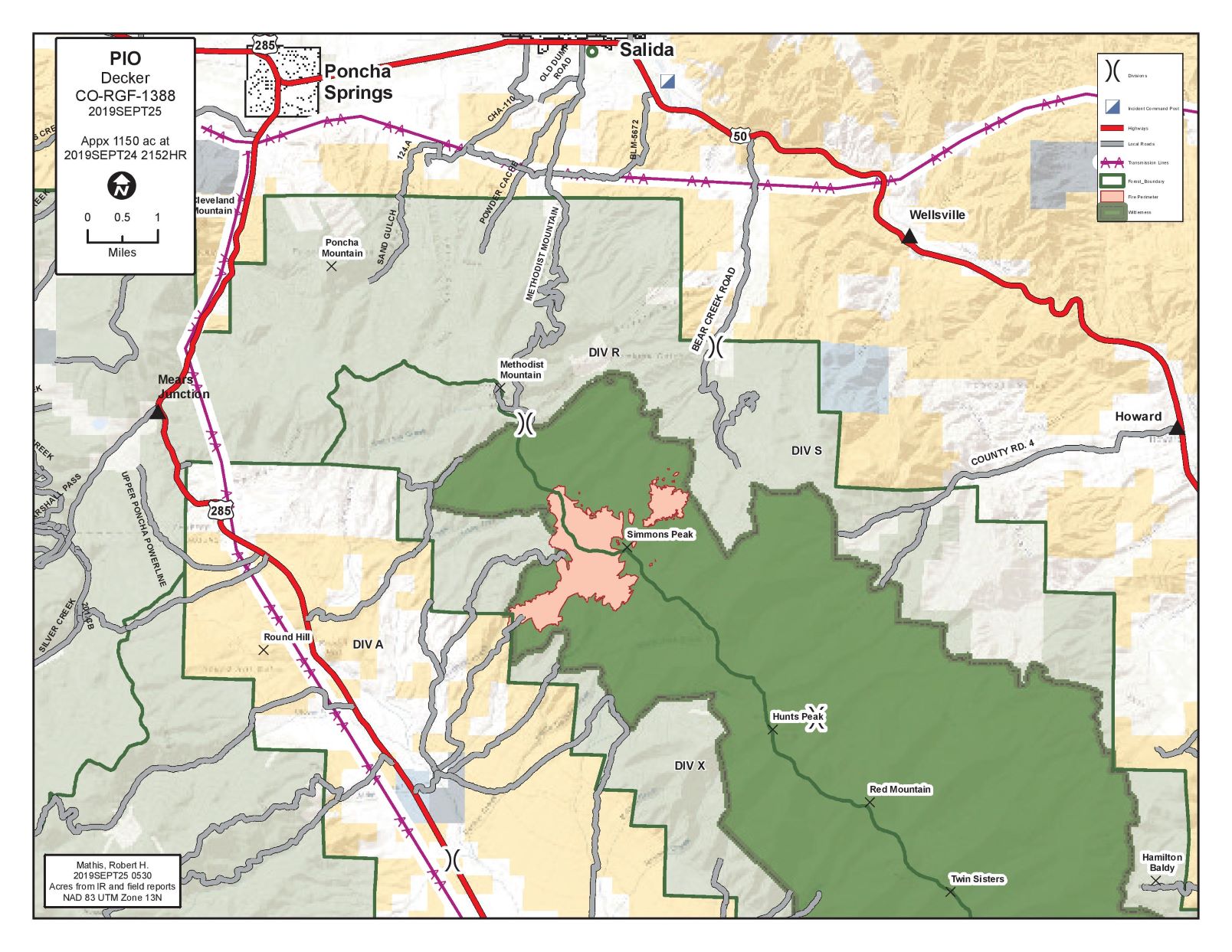
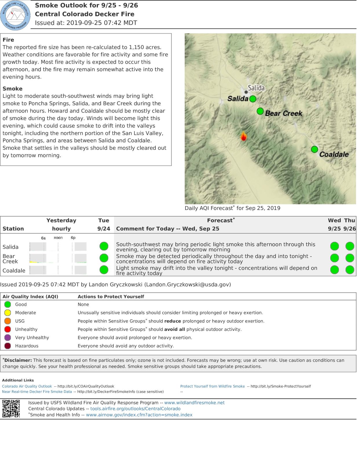
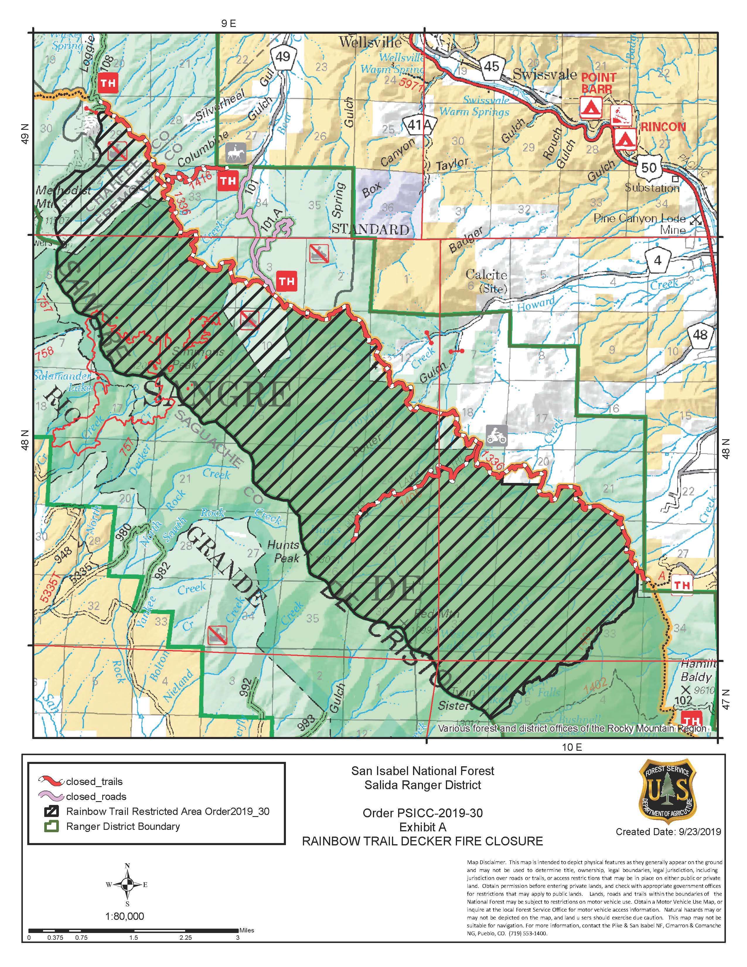
Situación actual: La mayoría del humo ayer vino del lado oriental del incendio de la cumbre Simmons. Equipos que estántrabajando en el lado oeste administraron una quemada pequeña a asegurar el incendio de Merkt Creek a Round Hill Trail.La área en el lado oriental continúo a retroceder lentamente hacia del Rainbow Trail. Se emitió un orden de cierre parapartes de los caminos 101 y 101A en las tierras del bosque nacional y el Rainbow Trail (camino 1336). El razón por estecierre es a proteger los recursos naturales y el la seguridad pública debido la actividad del incendio Decker. Administraronuna luz infrarrojo en la noche y recibieron un tamaño más preciso—1150 acres.
Hoy, los módulos de incendio de tierra salvaje de Tetón y el candado de Platte continuaran conectando los caminos ycalles con línea de contingencia a mantener el incendio en el lado oeste. Los “hotshots,” o bomberos especializados, y elequipo del valle de Juniper moverán hacia Rainbow Trail e implementarán operaciones de incendio si es necesario.También continuaran eliminar los combustibles a lo largo del Rainbow Trail de camino 101 a Columbine Trail. Más al suren el Rainbow Trail, los “hotshots” de Pike y el carro 629 de Wind Cave vigilan opciones para línea directa a conectarlosen los rasgos naturales como drenajes mojadas en Bear Creek. Estas acciones cumplen los objetivos de gestión a mantenerel incendio en la sierra y afuera de áreas de riesgo.
Hoy continuara cielos soleados y humedad relativa baja. Vientos del suroeste aumentaran durante la tarde con ráfagashasta 22 mph. Sin nubes, el incendio será más activo. Las combustibles caídos y muertos son los conductores principalesde actividad de fuego. El comportamiento del incendio es en su mayoría quemando despacio con algunos fuegos aisladosy cortas.
El bosque nacional estima que las áreas dentro de la sierra de Sangre de Cristo tienen hasta un 80% de mortalidad de árbolesde ataque de escarabajas y caídas de árboles. El incendio Decker está gestionando parar eliminar estos combustibles de altoriesgo del medioambiente para beneficio ecológico y para reducir el riesgo de incendios forestales catastróficos en el futuro.El incendio puede ser visible en la noche de los corredores de carreteras 50 y 285. Pide a motoristas que no paran en lacalzada y que estar libre de la calzada antes de observar el incendio. Por favor no llaman 911 a reportar comportamiento delincendio o pedir información del incendio Decker. Hay una línea disponible para novedades del incendio. 911 es solo paraemergencias.
Condiciones climáticas y de combustibles: Espera que el tiempo aumenta 68 grados y humedad relativa a 10-15 porciento. Vientos vienen del suroeste a 8-12 mph con ráfagas de 22mph. Clima seca con temperaturas anormalmente cálidasson probables durante la semana.Evacuaciones y cierres: Partes de caminos 101 y 101A en el bosque nacional y el Rainbow Trail (camino 1336) sur decamino 108 hacia el Stout Lakes Trail están cerrados. Se ha emitido una restricción de vuelo temporal (TRF) en el áreasobre el incendio a permitir operaciones aéreas. Recuerda: si vuelas, vosotros no podemos. No hay evacuaciones en estetiempo. Humo puede asentarse en el corredor de carretera 50 en la tarde o noche. Se alienta a los conductores a reducir lavelocidad cerca de fuego si el humo afecta la visibilidad.
Humo: Actualizaciones de humo son disponible en bit.ly/deckerfiresmoke. El pronóstico se puede encontrar ahttps://wildlandfiresmoke.net/outlooks/CentralColorado.
Estadísticas del incendio Decker:Tamaño: Approx. 1150 acresTotal de personal: 128Causa: relámpagoFecha de inicio: 8 de septiembre 2019Locación: 9 millas de Salida, CO
Información de contacto:Línea de información del incendio en inglés: (719) 626-1095 (8am-8pm)Email: 2019.Decker@firenet.govInciWeb: inciweb.ncwg.gov/incident/6592Facebook: Facebook.com/DeckerFire2019*Translated by Robert Lemus
Sunny Skies will Increase Fire Behavior Today
Related Incident:
Publication Type: News
September 25, 2019, 10:00 a.m.
Rio Grande National Forest
Pike-San Isabel National Forest
BLM - Front Range Fire and Aviation Management Unit
Justin Yankey, Incident Commander
Sunny Skies will Increase Fire Behavior Today
Current Situation: Most of the smoke yesterday was from the east side of the fire on Simmons Peak. Crews working the west side conducted a small burnout to secure the fire edge between Merkt Creek to Round Hill Trail. The spot on the east side continued to slowly back down towards the Rainbow Trail. A closure order was issued for portions of the 101 and 101A roads on National Forest lands and the Rainbow Trail (1336 trail). The purpose of this closure is to protect natural resources and public safety due to the continuing activity on the Decker Fire. An infrared flight was conducted last night providing a more accurate fire size – 1150 acres.
Today, Teton and Platte Canyon Wildland Fire Modules will continue connecting trails and roads with line to corral the fire on the west side. Alpine Hotshots and the Juniper Valley Hand Crew will manage fire spread towards the Rainbow Trail by implementing fire operation if necessary. Fuels will also continue to be removed along the Rainbow Trail from Road 101 to Columbine Trail. Further south on the Rainbow Trail, Pike Hotshots and Wind Cave Engine 629 will scout options for direct hand line to connect into natural features such as wet drainages in Bear Creek. These actions are to meet management objectives of keeping the fire in the Wilderness and away from values at risk.
Sunny skies, warm temperatures and low relative humidity will continue today. Southwest winds will increase during the afternoon with gust up to 22 mph. Without the clouds the fire will be more active. The dead and down fuel component is the main driver for fire activity. The fire behavior is mostly creeping, smoldering with some isolated torching and short runs. The U.S. Forest Service estimates that areas within the Wilderness have up to 80% tree mortality from beetle-kill and blowdown. The Decker Fire is being managed to remove these high-risk fuels from the landscape for ecological benefit and to reduce the risk for catastrophic wildfire in the future.
The fire may be visible from both the US 50 and US 285 corridors. Motorists are asked to not stop in the roadway and be clear of the roadway before stopping to observe the fire. Please do not call 911 to report fire behavior on the Decker Fire or to request fire information. A fire information line is available for fire updates. Please call 911 for emergencies only. Weather & Fuel Conditions: Temperatures will increase to 68 degrees with lower humidity at 10-15 percent. Winds will be out of the southwest at 8-12 mph with gust up to 22 mph. Dry weather with unseasonably warm temperatures are likely through the week.
Evacuations and Closures: Portions of the 101 and 101A roads on National Forest lands and the Rainbow Trail (1336 trail) south of 108 road to the Stout Lakes Trail (1403 trail) have been closed. A temporary flight restriction (TFR) has been issued over the fire area to allow for aerial operations. Remember: if you fly, we can’t. There are no evacuations at this time. Smoke may settle into the US Highway 50 corridor in the late afternoons or evenings. Drivers are encouraged to reduce speed near the fire if smoke affects visibility.
Smoke: Real-time smoke information is available at bit.ly/deckerfiresmokeinfo. Today’s smoke forecast for Salida and Arkansas River Valley is available at https://wildlandfiresmoke.net/outlooks/CentralColorado.
Decker Fire Statistics:
Size: 1150 acres
InciWeb: https://inciweb.nwcg.gov/incident/6592/
Total Personnel: 128
Cause: Lightning
Start Date: September 8, 2019
Location: 9 miles south of Salida, CO
Decker Fire Contacts:
Facebook: www.facebook.com/DeckerFire2019
Twitter: #DeckerFire2019
Fire Info Line: (719) 626-1095 (8 a.m. to 8 p.m.)
Closure in east Decker Fire area along Rainbow Trail
Related Incident:
Publication Type: Closures


Actualizacin del incendio Decker Martes 24 de septiembre 2019 1000am
Related Incident:
Publication Type: News
Actualización del incendio Decker
Martes 24 de septiembre, 2019, 10:00am
Bosque nacional de Rio Grande
Bosque nacional de Pike-San Isabel
BLM- unidad de gestión de incendios y aviación de área metropolitana
John Markalunas, Comandante del Incidente
Recursos adicionales llegan al incendio Decker
Situación actual: Ayer recursos adicionales llegaron al incendio Decker. Los equipos “hot shots,” o bomberos especializados, del Pike y Alpine y un helicóptero K-MAX llegarán al operación hoy. En el lado oeste del incendio, equipos completaron el construcción de líneas contingencias entre Saw Mill Gulch a Round Hill Trail. El nuevo comandante de incendios, Justin Yankey, llego y comienzo a informar el equipo actual. La transferencia comenzará esta noche.
A medida que el parte activo del incendio continua bajar del cumbre Simmons, los equipos fijarán por oportunidades a emplear tácticos directos. Las operaciones del incendio con soporte de tácticas aéreas se pueden utilizar a bajar el incendio a los elementos de control de Rainbow Trail cercas de Bear Creek. Se ha emitido una restricción de vuelo temporal (TFR) sobre el espacio aéreo del incendio. Los “hotshots” de Alpine y el equipo de bomberos del valle de Juniper continuaran eliminando combustibles a lo largo del Rainbow Trail cercas de Bear Creek y Columbine. Los “hotshots” de Pike y el carro de bomberos 629 de Wind Cave vigilarán las opciones a juntar una línea directa del incendio con elementos de control natural incluyendo el drenaje mojado sur de Bear Creek cercas del camino 101 del condado.
Hoy el pronóstico estima cielos solados, temperaturas cálidas, y humedad relativa baja. Sin nubes, el incendio pueda ser más activo. Los componentes de combustibles caídos y muertos son los conductores principales de la actividad del incendio. El comportamiento del incendio esta principalmente quemando despacio con fuegos aisladas y quemadas cortas.
El bosque nacional estima que las áreas dentro de la sierra de Sangre de Cristo tienen hasta un 80% de mortalidad de árboles de ataque de escarabajas y caídas de árboles. El incendio Decker está gestionando parar eliminar estos combustibles de alto riesgo del medioambiente para beneficio ecológico y para reducir el riesgo de incendios forestales catastróficos en el futuro.
El incendio puede ser visible en la noche de los corredores de carreteras 50 y 285. Pide a motoristas que no paran en la calzada y que estar libre de la calzada antes de observar el incendio. Por favor no llaman 911 a reportar comportamiento del incendio o pedir información del incendio Decker. Hay una línea disponible para novedades del incendio. 911 es solo para emergencias.
Condiciones climáticas y de combustibles: El tiempo será más cálida—más o menos 62 grados—con humedad un poco baja de ayer de 12-17%. Los vientos vienen del oeste y noroeste de 3-7mph con ráfagas hasta 12 mph. Clima seca con tiempos cálidos anormales son probables en los días finales de esta semana.
Evacuaciones y cierres: No hay evacuaciones y cierres en este tiempo. Humo puede asentarse en el corredor de carretera 50 en la tarde o noche. Se alienta a los conductores a reducir la velocidad cerca de fuego si el humo afecta la visibilidad.
Humo: Actualizaciones de humo son disponible en bit.ly/deckerfiresmokeinfo. El pronóstico se puede encontrar a https://wildlandfiresmoke.net/outlooks/CentralColorado.
Estadísticas del incendio Decker:
Tamaño: Approx. 1195 acres
Total de personal: 94
Causa: relámpago
Fecha de inicio: 8 de septiembre 2019
Locación: 9 millas de Salida, CO
Información de contacto:
Línea de información del incendio en inglés: (719) 626-1095 (8am-8pm)
Email: 2019.Decker@firenet.gov
InciWeb: inciweb.ncwg.gov/incident/6592
Facebook: Facebook.com/DeckerFire2019
*Translated by Robert Lemus