
Shoe Fire Daily Update for 10 19 2024
Related Incident: Shoe Fire
Publication Type: News
Email: 2024.shoe@firenet.gov
Incident Website: https://inciweb.wildfire.gov/incident-information/cashf-shoe-fire
Forest Website: https://www.fs.usda.gov/stnf
Fire Weather Forecast: https://www.weather.gov/wrh/CAFW?area=ECC005
Fire Information: 530-338-0317
Media Line: 909-855-4233
Hours: 08:00am to 8:00pm
Location: Shasta County, CA Start Date: Wednesday, October 9, 2024, at 6:57 p.m.
Cause: Human caused Size: 4,385
Percent Contained: 8% Vegetation: Timber, Chapparal
Number of Personnel Assigned: 1,393
A red flag warning is in effect until later this afternoon. High winds have significantly accelerated the drying conditions of local fuels, resulting in a decrease in fuel moisture levels. Ground crews will prioritize areas showing intense levels of heat by reinforcing existing containment lines using various aircraft, bulldozers, engines and hand crews. With a mobile retardant base established in Big Bend, aerial support will be maximized to ensure full suppression of heat reported along Beartrap and Sulunhares Creeks. Structure protection groups will conduct final risk assessments today and prepare structures for defense if deemed necessary. As wind speeds reduce, crews will resume defensive firing operations (strategic burning of vegetation between containment lines and the active fire) if it is safe to do so.
WEATHER: Gusty north to northeast winds will continue throughout the morning and diminishing in the afternoon. Humidity levels are expected to decrease, lighter north to northeast winds will continue tonight through Sunday morning and shifting to southwest winds Sunday afternoon.
EVACUATIONS: Mandatory evacuations remain in place for zone LKH-1448-B. Residents who have not evacuated are encouraged to do so. Evacuation information and alerts can be found by visiting protect.genasys.com
Information staff for the Shoe Fire are working diligently to provide timely and accurate information to the public. Fire updates can be found on the Shoe Fire 2024 Facebook page: www.facebook.com/2024ShoeFire/
FIRE AND SMOKE MAP:
Updates on smoke conditions can be found under the following link
https://outlooks.wildlandfiresmoke.net/outlook/59ecb6c0?
ROAD CLOSURES:
- Fenders Ferry Road at Pit River 7 Bridge: West-Bound Fenders Ferry Road (Also known as 34N17 - Forest Service Road 27) at the Pit River Bridge/Pit 7
- Ferry Road is closed at McCloud Bridge: East-Bound Fenders Ferry Road at the McCloud River Bridge
FOREST CLOSURES:
https://www.fs.usda.gov/detailfull/stnf/alerts-notices/?cid=stelprdb5392380
Elk Fire Update 10 19 2024
Related Incident: Elk Fire 2024
Publication Type: News
Elk Fire Update
Saturday, October 19, 2024 - 9:00 a.m.
Rocky Mountain Complex Incident Management Team 1
Dan Dallas, Incident Commander
Information Phone: 307-303-7642
Hours: 8 a.m. to 8 p.m.
Email: 2024.Elk@firenet.gov
InciWeb: https://inciweb.wildfire.gov/incident-information/wybhf-elk-fire-2024
Facebook: https://www.facebook.com/bighornnf
Information Linktree: https://linktr.ee/2024ElkFire
Special Notes: Rocky Mountain Complex Incident Management Team 1 (RM CIMT1) assumed management of the Elk Fire at 6 p.m. yesterday. We have completed transitioning with RM CIMT3, and we thank them for their service on the fire these past 18 days. Their hard work has set us up to successfully complete incident objectives.
Following recent precipitation, the status of evacuations and closures has been evolving. Please continue checking the evacuation and closure links below for current information.
Current Situation: A strong Autumn storm system passed over the Elk Fire on Thursday and Friday, dropping about an inch of precipitation in the form of rain and snow. The moisture markedly reduced fire behavior across the fire area, giving firefighters a welcome reprieve. With clearing skies today, fire personnel will be assessing post-storm conditions to determine current work priorities and opportunities. The wet conditions will likely mean limited fire behavior and minimal fire growth for at least a few days. During this time, firefighters will have the opportunity to shift focus from battling active fire to planning for end-of-incident activities like suppression repair and backhaul of supplies and equipment. All decisions on future activities will be premised on firefighter and public safety and the need to protect critical resources like roads, trails, riparian areas, recreation facilities, and structures.
A warming and drying trend is expected to reestablish next week, and smoke could again become visible in the fire area. Firefighting crews will remain alert and ready for any suppression actions that may need to be taken. The Elk Fire remains unchanged today at 96,179 acres and 44% contained.
Weather, Fuels, and Fire Behavior: High pressure will build back into northern Wyoming today, bringing clearer skies, warmer temperatures, and lower relative humidity. Winds will be light, with SW drainage winds prevailing through mid-morning and evening, and easterly upslope flow during the day. Solar insolation and warming temperatures will accelerate snowmelt across the higher elevations. Moisture from the recent storm will minimize fire behavior to creeping and smoldering. No significant fire growth is expected today.
Evacuations: For information on Johnson County evacuations, go to Johnson County Emergency Management’s Facebook page: https://www.facebook.com/JohnsonCoWYEMC . For info on Sheridan County evacuations and road closures, go to the Sheridan County Emergency Management website: www.tinyurl.com/2s38bcc5 . You can also call the Sheridan County Sheriff’s Office (307-672-3455) or Sheridan County Emergency Management (307-752-2174).
Closures: US Highway 14 is closed between Burgess Junction and Dayton. View the Wyoming Department of Transportation road-closure map here: https://www.wyoroad.info/ . Bighorn National Forest closure Order No. 02-02-06-24-08 is in effect. The order and map can be viewed here: https://www.fs.usda.gov/alerts/bighorn/alerts-notices .
Elk Fire Statistics:
Size: 96,179 acres | Containment: 44% | Total Personnel: 807 | Location: West of Sheridan, WY
Reported: September 27, 2024 | Cause: lightning
###
Valley Fire Update 10 19 2024
Related Incident: 2024 Valley Fire
Publication Type: News
Incident Activity: About 65% of the 33 miles of dozer and handline created to contain the Valley Fire has been repaired to a more natural state ready for regrowth. That percentage is expected to increase significantly today. Suppression repair work will be more visible in Southeast Boise this weekend. Firefighters and heavy equipment operators will be making repairs in steep areas near Council Spring Road in Harris Ranch. This is challenging work and it is important that the public honor trail closures for firefighter and public safety. Seed has arrived at the Valley Fire Incident Command. The seed is carefully selected to suit the Boise Foothills landscape and will be mixed prior to being spread on the repaired fire suppression/containment lines. Nevada Team 2 will have a public information officer in the Council Spring Road area available for public questions and to assist media. Please contact Robbie Johnson, Nevada Team 2/Idaho Department of Lands Public Information Officer for questions, additional information, or interview requests.
Trail Closures in Valley Fire Area: All roads and trails on the Boise Front segment of the Boise River WMA west of Highway 21 and north of Warm Springs Avenue remain closed to all entry until further notice. This closure also extends to all travel off roads and trails. The public is asked to please honor closure signs at trailheads even if fire activity is not visible. Members of the public have been recreating in closed areas. This poses a safety risk to the public and fire crews. Fire operations including the use of heavy equipment are ongoing.
Weather: Freezing overnight temperatures again under clear skies in the Valley Fire camp where fire crews are staying as they get closer to wrapping up work on suppression repair. Highs in the Valley Fire area will be an average of around 55 degrees with no meaningful precipitation in the forecast.
Valley Fire Overview: The fire was reported Friday, October 4, 2024, about 1 mile east of Boise on the north side of Idaho State Highway 21. The fire was very visible from East Boise as it burned in mostly grassy fuels in the Boise Foothills. Quick work on initial attack stopped the fire from reaching nearby homes. The current fire cost estimate is $4.2 million.
RailroadDaly Fire Update 11 13 2024
Related Incident:
Publication Type: News
Type 4 Incident Team
Location: Bitterroot NF: Railroad Creek/ Skalkaho Creek confluence, 26 miles southeast of Hamilton
Beaverhead-Deerlodge NF: 20 Miles northwest of Georgetown Lake Dam off Skalkaho Hwy 38
Start Date: 7/25/2024
Cause: Undetermined
Daly Fire Acres: 11,493 Railroad Fire Acres: 1,583
Total Personnel: 10
Current Status: Due to snow and cooler temperatures this fire in now contained and in patrol status.
Pack Trail Fire Daily Update October 19 2024 10 19 2024
Related Incident:
Publication Type: News
PACK TRAIL FIRE
Saturday, October 19, 2024 Update
Fire Information Phone: 307-395-2351 | Email: 2024.Packtrail
Total Acres: 89,186 Confined: 62% Total Personnel: 541
Operations – The fire saw greatly moderated fire behavior today, however, there was not as much moisture as anticipated. As the week warms up and becomes windy, grasses and fine fuels will dry out again causing fire activity to increase. On the southern edge, the fire continues to smolder and slowly creep through thick duff and in some areas where there was not much moisture, grasses burned with flame lengths of 2-5 feet. Firefighters cooled down areas of heat to secure the fire line. Crews continue to put out hotspots, repair culverts, and clean up slash from the roadsides. On the west flank, crews patrolled the Bacon Creek area and are working to connect containment lines in rugged terrain above Elk Track Ranch. On the east side, crews continue to backhaul equipment, monitor, hold, improve containment lines. Crews who have UTV’s will access deeper into the fire’s footprint to help prevent deep ruts on the roads from heavy trucks.
Safety – Despite the recent precipitation, Teton Interagency Fire Managers are maintaining the Very High Fire Danger Rating for Grand Teton National Park, the Bridger-Teton National Forest, the Shoshone National Forest, and the National Elk Refuge. This precipitation was not a fire season ending event. Due to wind, fuels will begin to rapidly dry out when the snow melts. Any spark can ignite fire which can grow rapidly into a major incident. Residents and visitors are urged to exercise extreme caution with fires or other possible ignition sources. Never leave your campfire unattended, even for a moment. Always ensure someone is watching it or extinguish it completely before leaving. Drown the fire with water, stir the ashes, and feel with the back of your hand to confirm it is cool.
Please use caution while driving these areas, especially on narrow secondary roads. Always expect to encounter fire vehicles and heavy equipment in and around the fire area. Check with WY-DOT for possible closures due to fire activity, especially if you are planning to travel on US-26 across the Continental Divide. Closures are not expected, but with active fire in the area checking status before travel is recommended.
“If you fly, we can’t.” Remember that flying a personal drone over a fire area during a temporary flight restriction is illegal and can be an extremely dangerous threat to both our aviators and firefighters on the ground.
Weather – Today will be sunny and temperature will be 42-56 degrees with a minimum relative humidity’s between 23% - 37%. Winds from the northeast will be 4-8 MPH with gusts up to 15. Warmer and drier weather will return over the week. To learn more about air quality, visit Fire.AirNow.Gov.
Evacuations – Lava Mountain Lodge, Roaring River Subdivision, Buckboard Subdivision, Double Bar J Ranch, Lava Creek Ranch, Triangle C Ranch, Pelham Lake, Sheridan Creek Camp Areas, Old Mackenzie Ranch, Upper Gros Ventre, Darwin Ranch have been reduced to Level 2 “Set” status. Brooks Lake Lodge, Pinnacle, Breccia, and Long Creek, and Dunior areas have been reduced to a Level 2 “Ready” status. Union Pass subdivision remains in a Level 2 “Set” status. See the Fremont County Emergency Management Facebook Page for alerts and updates. See the Teton County Emergency Management website updates and to sign up for emergency alerts through Everbridge.
Road Closures – The Union Pass Road is closed on the Pinedale Ranger District (BTNF) from Mosquito Lake to the Moon Lake Road on the Wind River District (SHO). Moon Lake Road is also closed.
Forest Closures - Closure Order #04-03-24-317 is in effect from October 14, 2024 at 12:00 p.m. through November 15, 2024 at 12:00 a.m. unless rescinded. This order supersedes previous orders, including #04-03-24-316, prohibiting the same or similar acts in the same described area.
For more information, visit: Facebook: USDA Forest Service - Bridger-Teton National Forest, USDA Forest Service - Shoshone National Forest Pack Trail Inciweb: https://inciweb.wildfire.gov/incident-information/wybtf-pack-trail-fire
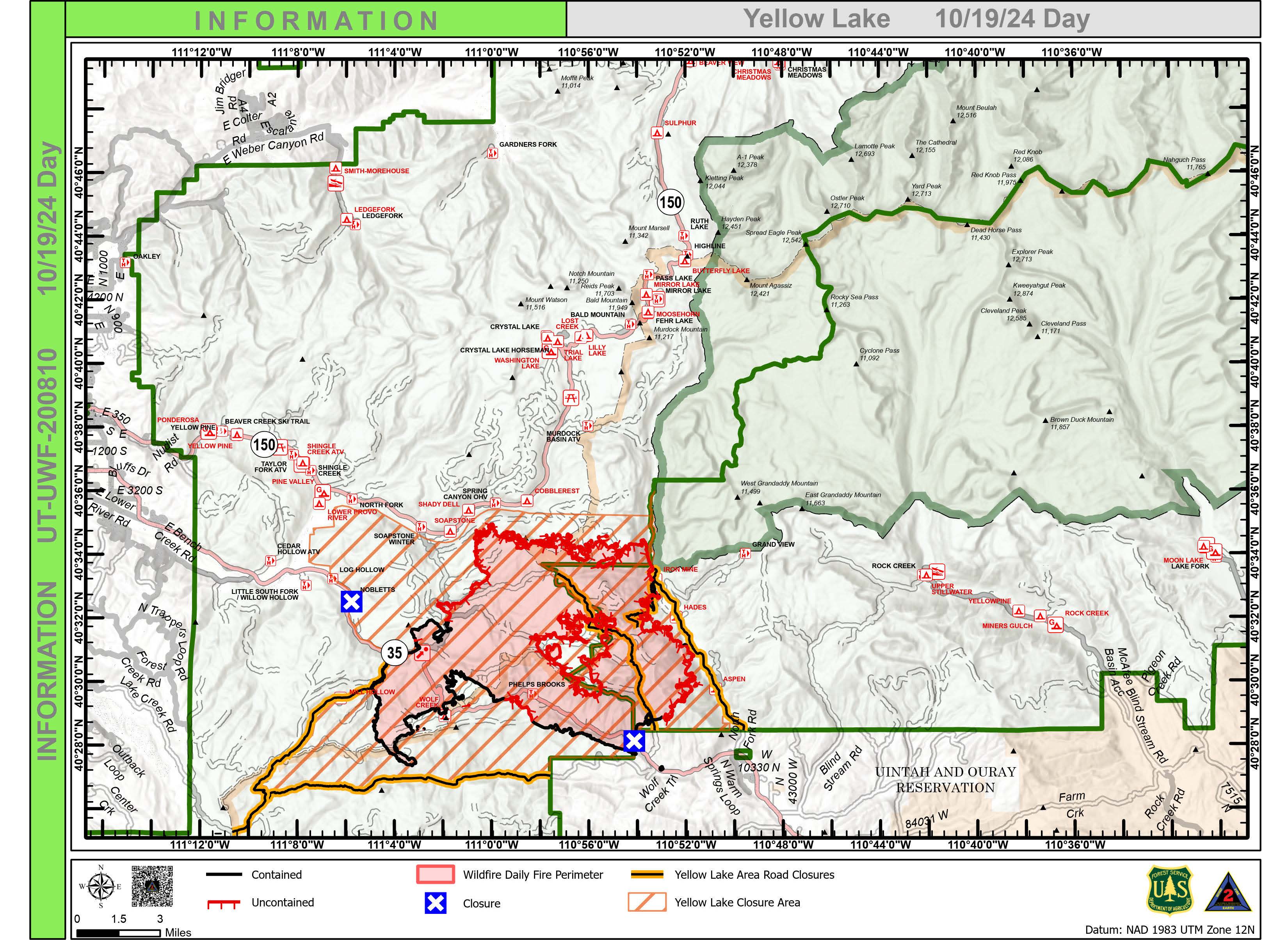
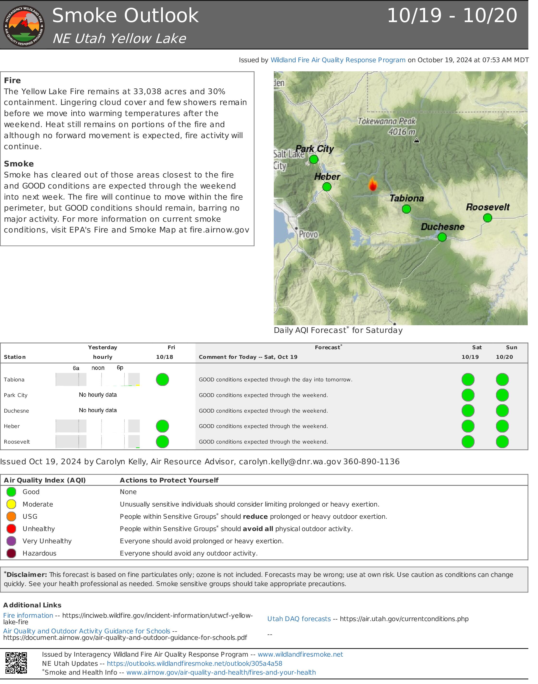
Yellow Lake Fire Update 10 19 2024
Related Incident: Yellow Lake Fire
Publication Type: News
Yellow Lake Fire
Incident Update October 19, 2024
Size at time of update: 33,038 Acres
Containment: 30%
Personnel: 433
Start: Saturday, September 28, 2024
Cause: Human Caused (Under Investigation)
Location: 10 miles southeast of Francis, Utah
Wasatch and Duchesne County evacuation orders were lifted at 9:00 a.m. - Forest closures remain in effect.
Personnel numbers on the Yellow Lake Fire continue to decline as operations ramp down. Six days ago, 889 personnel were on the fire – today there are 433.
Rain and snow fell yesterday with up to 1.23 inches of precipitation recorded. However, fire managers say there is still some heat out there. Aircraft, equipped with infrared technology, flew the fire area last night and detected isolated heat sources on the north side. Hot spots were also picked up along the North Fork of Duchesne, as well as a few in the “donut hole” in the middle of the fire perimeter.
As the weather warms today, smoke from smoldering heavy fuels, duff and leaf litter could show up. An isolated snag torching would not be unexpected. However, fire movement is not expected.
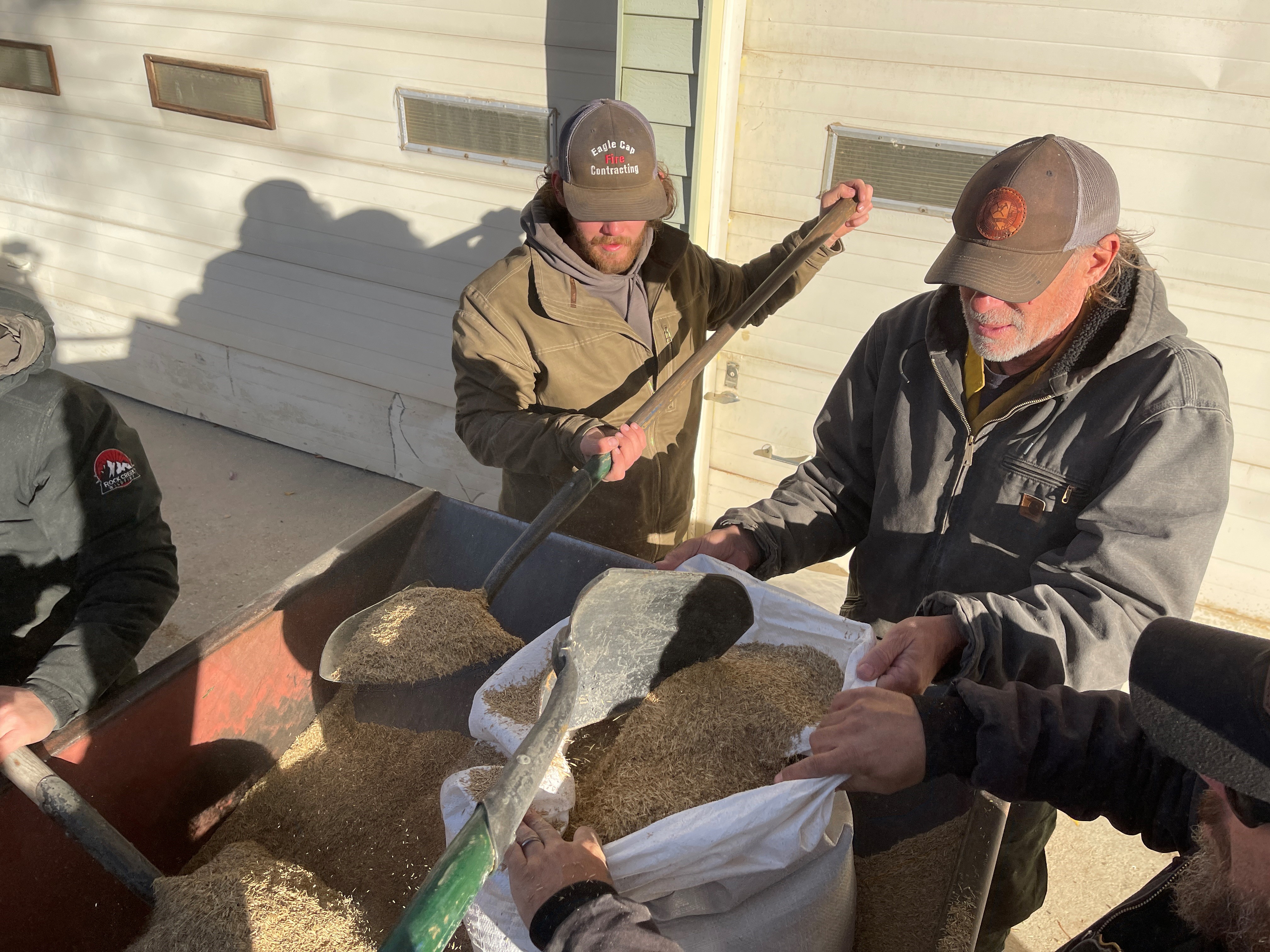
Fire suppression has transitioned to repair of dozer lines, pump and hose removal, and hydrological improvements such as water bars.
A Burned Area Emergency Response (BAER) team will be coming next week to assess damage and recommend ways to mitigate changes to the landscape. Suppression repair is important for water quality, especially within adjacent watersheds. Meanwhile, fire crews are working with local Forest Service Resource Advisors to address immediate repair needs.
A community meeting will be held this afternoon at 4:00 p.m. at the South Summit Middle School Auditorium in Kamas to discuss fire suppression, rehabilitation and what’s next.
Forest Closures:
- Updated October 18, 2024, the Yellow Lake Fire closure area has been reduced on the Uinta-Wasatch-Cache National Forest. This Order shall remain in effect until November 25, 2024, unless rescinded.
https://www.fs.usda.gov/Internet/FSE_DOCUMENTS/fseprd1208350.pdf - Updated October 18, 2024, the Yellow Lake Fire closure area has been reduced on the Ashley National Forest. This closure will remain in place through December 31, 2024, or until rescinded.
For updated evacuation zones, please visit:
https://emergency-management-operations-wasatch.hub.arcgis.com/
https://tricountyemergencyalert.genasys.com/portal/en
https://www.fs.usda.gov/Internet/FSE_DOCUMENTS/fseprd1208878.pdf
Garden and Red Rock Fires Update 10 19 2024
Related Incident:
Publication Type: News
Evacuations reduced on Garden and Red Rock Fires
Red Rock Fire
Operations: Crews re-assessed conditions yesterday as the snow melted around the fire area. The landscape still has lots of fire and heat, although behavior remains moderated. Firefighters scouted for ways to tie together fire lines on the north/northeast along FR 101 east to Ridge Road. Feller Buncher and mastication continued removing hazard trees to ensure firefighter safety. Crews went in near Moyer Peak in the morning but had to leave as temperatures warmed and road conditions deteriorated. Near Yellowjacket, crews extinguished a 10x10 area where the fire crossed the line. Fire managers anticipate crews re-engaging more heavily today, constructing additional handlines and clearing vegetation along road systems with heavy equipment. Firefighters will continue to mop up areas where previous firing operations occurred. There were no crews on the Napias Creek Fire yesterday, but firefighters will re-engage today to address any areas of concern.
Garden Fire
Operations: Fire behavior remained moderated yesterday, and firefighters patrolled the Salmon River and Panther Creek corridors. There was still smoke up high where fire remained in heavy fuels such as logs, stumps, and trees, although light fuels such as grass were not carrying fire. Crews will continue to monitor the Garden fire and act if necessary.
Additional Information
Weather: For Saturday, another cold start is expected, but abundant sunshine will warm afternoon highs 10 to 15 degrees, with highs mainly 52 to 62. Humidity readings will only slightly decrease from the previous afternoon. Wind will continue light with gusts staying below 15 mph. The next storm expected Monday will bring little precipitation, some moderate gusty wind, and temperatures cooling 5 to 10 degrees.
Smoke: For smoke information, please go to: https://www.airnow.gov/education/what-you-can-do/, or https://outlooks.airfire.org/outlook/ded7837a
Closures: The Salmon‐Challis National Forest has implemented a separate and reduced Red Rock and Garden Fire Closure, Order Number: 04‐13‐24‐027 and Order Number 04-13-24-028, effective as of 8:00 pm, Wednesday, October 16, 2024. https://www.fs.usda.gov/alerts/scnf/alerts-notices
Safety: A Temporary Flight Restriction (TFR) is in place over the Red Rock and Garden fire areas, which includes uncrewed aircraft systems or drones. Reminder that if you fly we can’t, unauthorized drone flights pose serious risks to firefighter and public safety and the effectiveness of wildfire suppression operations.
Please stay out of the fire area. There is still active fire behavior in the fire area. There are multiple roads and bridges that have been destroyed or are impassable. The updated forest closure notice that encompasses both the Red Rock Fire and Garden Fire areas includes multiple road and area closures. Barricade closures will be posted at road intersections and forest boundaries.
Evacuations: For evacuation information in Lemhi County regarding both the Red Rock and Garden fires please go to: https://www.lemhicountyidaho.org/emergency-management-department.
Rail Ridge Daily Update 10 19 2024
Related Incident:
Publication Type: News
Rail Ridge Fire Update
Saturday, October 19, 2024
Central Oregon Wildfire Information: centraloregonfire.org
Email: 2024.railridge@firenet.gov – Phone: 541-208-7111
Social Media, Evacuation and Closure Information: https://linktr.ee/RailRidgeFire
Acres: 176,383 – Containment: 90% – Detection: 09/02/24 – Cause: Lightning – Personnel: 516
Operations Section Chief Morning Briefing on Facebook
Special Notes: USFS and BLM fire area closures are still in effect. To stay informed on any changes to fire closures and Wheeler County and Grant County evacuation levels, visit https://linktr.ee/RailRidgeFire. Please remain out of closed areas for your safety and the safety of the firefighters. Fire managers are meeting daily to assess the closure areas and to discuss the upcoming hunting seasons.
Firefighting and suppression repair is a very dangerous job with many hazards. Some of those hazards on the Rail Ridge Fire recently include slick roads and adverse driving conditions due to cold weather and precipitation, fire-weakened hazard trees, heavy equipment operations, long drive times to the fireline and operating chainsaws. NW Team 2 has successfully mitigated the risks of these hazards and has experienced zero accidents and only one illness.
Fire Behavior & Weather: After a chilly start, Friday afternoon temperatures ranged from low to mid-40s at high elevations, to upper 50s in the warmer valleys. Minimum humidity dropped to 30-40 percent in the driest locations. Winds from the south-southwest 5-10 mph with a few gusts to 15 mph turned out of the west-northwest late in the afternoon. Fire behavior will be minimal until sufficient drying occurs. Primary fire behavior characteristics include smoldering ground fuels with very limited creeping and possibly some flare-ups when there is alignment between an ignition source, sunshine, aspect, wind, and elevation. A warming, drying trend is anticipated over the next few days.
Operations Yesterday: Between the Incident Command Post and the Rager Forward Operating Base there are more than 500 personnel assigned to assist with the Rail Ridge Fire. Today, the Situation Unit Leader along with Geographic Information System (GIS) professionals created a computer application called the Rail Ridge Fire Suppression Repair Dashboard so the team can track the work being done on the ground. To date, firefighters have built 22 miles of handline, 85 miles of dozer line, 48 miles of other fireline, and have used 99 miles of road as containment line to protect the values at risk.
Operations Today: The shaded fuel break at FS Road 3850 is expected to be complete by end of shift today. The main objective there is to ensure that the community of Dayville and other unincorporated areas are protected now and in the event of future fires. A shaded fuel break is a strip of land where the vegetation is altered to reduce the amount of fuel available for a fire. This is done by removing or modifying the understory vegetation while keeping the canopy intact. Shaded fuel breaks help to improve fire safety, enhance forest health, and reduce the intensity and severity of wildfires.
USFS & BLM Closures / Evacuation Information / Fire Restrictions for the Rail Ridge Fire area can be found at: https://linktr.ee/RailRidgeFire.
Bird Hunting and the Rail Ridge Fire 10 28 2024
Related Incident:
Publication Type: Announcement
Bird Hunting and The Rail Ridge Fire
Wether you’re trying to fill that fall turkey tag or chasing Chukars on steep terrain, take a moment to review the current wildfire emergency closure areas. It’s always a good idea to know before you go. Good luck out there!
Bird Hunting - Currently open:
Eurasian collared dove and mourning dove, ruffed and blue grouse, mourning dove, rooster pheasant, chukar/Hungarian partridge, California and mountain quail, eastern fall turkey, duck, coot, goose, and Wilson's snipe, goose.
East Area, Bird Hunting Recreation Report - https://myodfw.com/recreation-report/game-bird-hunting-report/east-area
Safety hazards while hunting near the Rail Ridge Fire area:
https://www.fs.usda.gov/alerts/ochoco/alerts-notices/?aid=9126
Hunting and Fire Danger in Oregon: https://myodfw.com/articles/hunting-and-fire-danger-oregon
FUN FACT
“In 1882 the Willamette Valley of Oregon was the site of the first successful introduction of ring-necked pheasants in the United States. Those birds were transported by sea directly from China by Judge Owen Denny. The transplanted birds found perfect habitat and soon populations burgeoned into the tens of thousands.” Oregon Department of Fish and Wildlife https://myodfw.com/
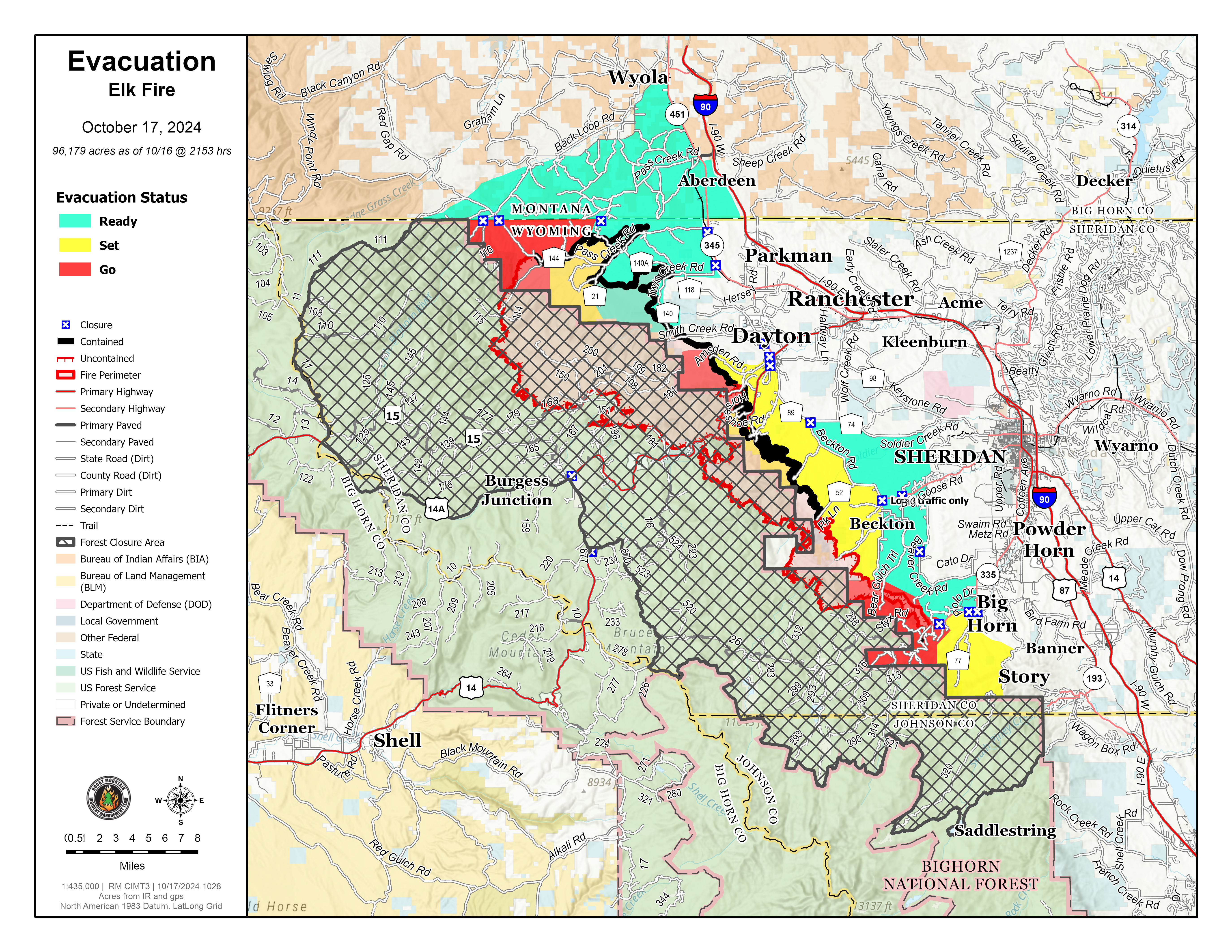
Sheridan County Evacuation Information 10 18 2024
Related Incident: Elk Fire 2024
Publication Type: Announcement
October 18, 2024
FROM: Sheridan County Emergency Management
Sheridan County Wyoming Contact: 307-675-2569, scema@sheridancountywy.gov
For Immediate Release
Press Release: New Change to Evacuation Map for the Elk Fire
For Immediate Release: October 18, 2024 11:00 a.m. Contact: Sheridan County Sheriff’s Office
The Sheridan County Sheriff’s Office and Incident Command are working closely together to reevaluate the evacuation status levels for the areas in proximity to the Elk Fire. With the welcome precipitation yesterday and overnight and expected fire behavior, we will be downgrading several areas.
Effective immediately:
The following area has been downgraded to a “Set” status:
- The area West of Slack Road and East Pass Creek Road, including the Northwest section of Pass Creek Rd to the Montana line, West to the Forest Service boundary. This also includes the Little Horn Canyon Cabins.
- Rapid Creek, Red Grade area- the area west of Bear Gulch Trail to Bear Gulch Road continuing in a southeasterly manner to Hidden Valley Road, continuing south to the US Forest Service boundary. This includes all cabins within the Teepee Cabin group, all cabins in the Black Tooth Cabin Association and homes on Lower Hideaway Lane, Red Poll Lane, and Upper Hideaway Lane. This also includes Stumpy Ridge, Helsberg, and Folley Ranch. As well as cabins along FSR 296.
- Highway 335 at the Intersection of Brinton Road will open today.
- Red Grade Road at the winter closure point will remain a hard closure. Only fire personnel and law enforcement will be allowed in that area.
Officials will continue to monitor fire behavior and assess the need to change any evacuation levels and road closures on an as needed basis.
We encourage everyone to monitor the Sheridan County Facebook page and the Sheridan County website for the most up-to-date information.
Thank you for your cooperation as we work to ensure the safety of all residents.
Sheridan County Emergency Management Phone: 307-752-2174
The Elk Fire hotline number is: 307-303-7642
Sheridan County Web Site: www.sheridancountywy.gov Follow us on Facebook at https://www.facebook.com/SheridanCountyGovernment for live updates.