
Sheridan County Access to Red Grade Road on Friday 101824 published 10 17 2024
Related Incident: Elk Fire 2024
Publication Type: Announcement
Press Release: Red Grade Road Cabin Owners Granted Limited Access Friday October 18
In cooperation with the incident management team, the Sheridan County Sheriff and Bighorn National Forest are allowing access for owners of cabins along Red Grade Road tomorrow, Friday, October 18, to winterize their cabins. Please remember that this is a dynamic situation and is subject to change. This access is for Friday only, and will only be allowed from 9:00 a.m. to 5:00 p.m., and is ONLY for cabins located along Red Grade Road. The protocol for access is as follows:
- Check-in with law enforcement at Red Grade Road closure with official ID, plate number, and location/address of cabin.
- This is only for owners of cabins along Red Grade Road.
- Law enforcement will have a presence along Red Grade Road to ensure safety.
- Cabin owners must check-out with law enforcement at the Red Grade Road closure by 5:00 p.m.
- No trailers or heavy equipment will be allowed past the Red Grade Road closure.
Further opportunities may be available in future days, as fire conditions allow, and for others interested in retrieving items from the mountain.
We encourage everyone to monitor the Sheridan County Facebook page and the Sheridan County website for the most up-to-date information.
Thank you for your cooperation as we work to ensure the safety of all residents.
Sheridan County Emergency Management
Phone: 307-752-2174, 307-675-2569, scema@sheridancountywy.gov
Sheridan County Web Site: www.sheridancountywy.gov
Follow us on Facebook at https://www.facebook.com/SheridanCountyGovernment for live updates.
Sheridan County Evacuation Information 10 17 2024
Related Incident: Elk Fire 2024
Publication Type: Announcement
New Change to Evacuation Map for the Elk Fire
For Immediate Release: October 17, 2024 a.m.
The Sheridan County Sheriff’s Office and Incident Command are working closely together to reevaluate the evacuation status levels for the areas in proximity to the Elk Fire. With the onset of precipitation and expected fire behavior, we will be downgrading several areas.
Effective immediately:
The following area has been downgraded to a “Set” status:
The area South of PK Lane and West of Beckton, Big Goose Road and Rapid Creek Road to the black fire containment line.
Eaton’s Ranch Headquarters
The following area has been removed from any evacuation level status:
Everything South and West of Bird Farm Road and HWY 87 Intersection and West of HWY 193 to the Johnson County Line and Forest Service Boundary, and West to the Brinton Road and Highway 335 Intersection, moving southeast along the foothills to Kemp Creek and then south to the Forest Service Boundary. This includes the community of Story.
The Town of Dayton
Officials will continue to monitor fire behavior and assess the need to change any evacuation levels on an as needed basis.
We encourage everyone to monitor the Sheridan County Facebook page and the Sheridan County website for the most up-to-date information.
Thank you for your cooperation as we work to ensure the safety of all residents.
Sheridan County Emergency Management
Phone: 307-752-2174, 307-675-2569, scema@sheridancountywy.gov
Sheridan County Web Site: www.sheridancountywy.gov
Follow us on Facebook at https://www.facebook.com/SheridanCountyGovernment for live updates.
The Elk Fire hotline number is: 307-303-7642
Phase 2 Line PostFire BAER Soil Burn Severity Map Released 10 17 2024
Related Incident: Southern California Post-Fire BAER 2024
Publication Type: News
Phase 2 Line Post-Fire BAER Soil Burn Severity Map Released
October 17, 2024
USDA Forest Service Burned Area Emergency Response (BAER) specialists recently completed their data gathering and analysis for Phase 2 of the Line Fire burned area to produce a combined post-fire Soil Burn Severity (SBS) map for Phases 1 and 2. Phase 1 BAER assessment of the Line Fire was paused when the fire became active and burned approximately an additional 5,000 acres.
The BAER assessment team used initial remote sensing imagery with their field-validated soils data to develop and produce a map showing soil burn severity levels for the burned area. The SBS is broken into four different classes: unburned/very low (green), low (blue), moderate (yellow), and high (red). For more information on these different SBS classifications, see the BAER Information Brief at: Cabdf Southern California Postfire Baer 2024 - | InciWeb (wildfire.gov).
The BAER SBS map and data display categories of unburned/very low, low, moderate, and high soil burn severity in different colors for the different categories. Approximately 30% of the 44,132 acres analyzed by the BAER team are either unburned/very low or low soil burn severity, while 50% sustained a moderate soil burn severity, and about 20% were identified as having high soil burn severity.
There are several types of fire severity and intensity maps that you may see. Although they look different for the same fire, they are accurate. This is because fire severity or intensity are different metrics of the fire effects on a specific resource such as soils, tree canopies, vegetation or wildlife habitat. Burned Area Emergency Response (BAER) maps are primarily measures of fire effects on soils. See also Fire Intensity vs. Soil Severity Effects BAER Information Brief at: Cabdf Southern California Postfire Baer 2024 - | InciWeb (wildfire.gov).
The BAER team relies on their final soil burn severity map to produce data, which they are using in their subsequent modeling and determinations of post-fire runoff, erosion, and sedimentation. The BAER team, the US Geological Survey (USGS), and the California State Watershed Emergency Response Team (WERT) all utilize the soil burn severity map as an analysis tool to estimate post-fire watershed response to precipitation events. In specific areas that experienced moderate to high burn severity, there could be increased runoff from steep hillslopes which could result in increases of post-fire soil erosion, sedimentation, and potential debris flows.
The Phase 2 Line Fire SBS map can be downloaded at the Southern CA Post-Fire BAER 2024 InciWeb site: Cabdf Southern California Postfire Baer 2024 Information | InciWeb (wildfire.gov) under the Maps” tab.
BAER SAFETY MESSAGE: Everyone near and downstream from the burned areas should remain alert and stay updated on weather conditions that may result in heavy rains and increased water runoff. Flash flooding may occur quickly during heavy rain events--be prepared to act. Current weather and emergency notifications can be found at the National Weather Service website: www.weather.gov/lox/.
###
FOREST SERVICE LAVA POSTFIRE BAER ASSESSMENT REPORT SUMMARY RELEASED10 17 2024
Related Incident: Boise NF Post-Fire BAER 2024
Publication Type: News
FOREST SERVICE: Lava Post-Fire BAER Assessment Report Summary Released
The Forest Service—Boise National Forest completed a Burned Area Emergency Response (BAER) post-fire assessment of the Lava burned area and affected watersheds to determine their response, soil conditions, potential threats, and recommended BAER emergency stabilization measures and actions on National Forest System (NFS) lands. BAER emergency treatments and activities are designed to decrease possible impacts to critical values from the burned areas during rainstorm events such as: human life and safety, property, critical natural resources, and cultural resources.
NOTE: Attached below as “Related Information” is a PDF documents called “LAVA Post-Fire BAER Assessment Report Summary_PUBLIC”.
BAER SAFETY MESSAGE: Everyone near and downstream from the burned areas should remain alert and stay updated on weather conditions that may result in heavy rains and increased water runoff. Flash flooding may occur quickly during heavy rain events--be prepared to act. Current weather and emergency notifications can be found at the National Weather Service website: www.weather.gov/boi/.
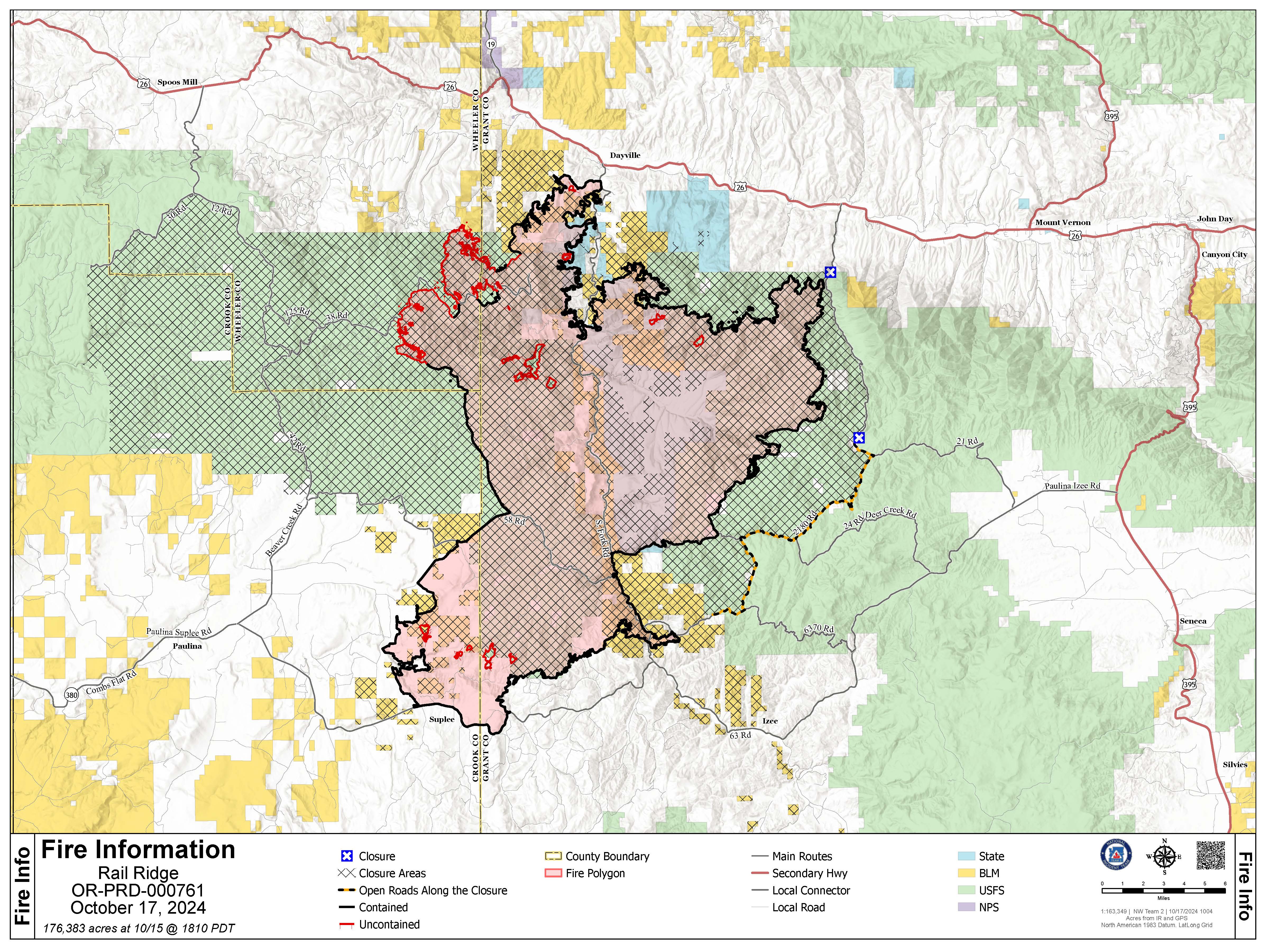
Rail Ridge Daily Update 10 17 2024
Related Incident:
Publication Type: News
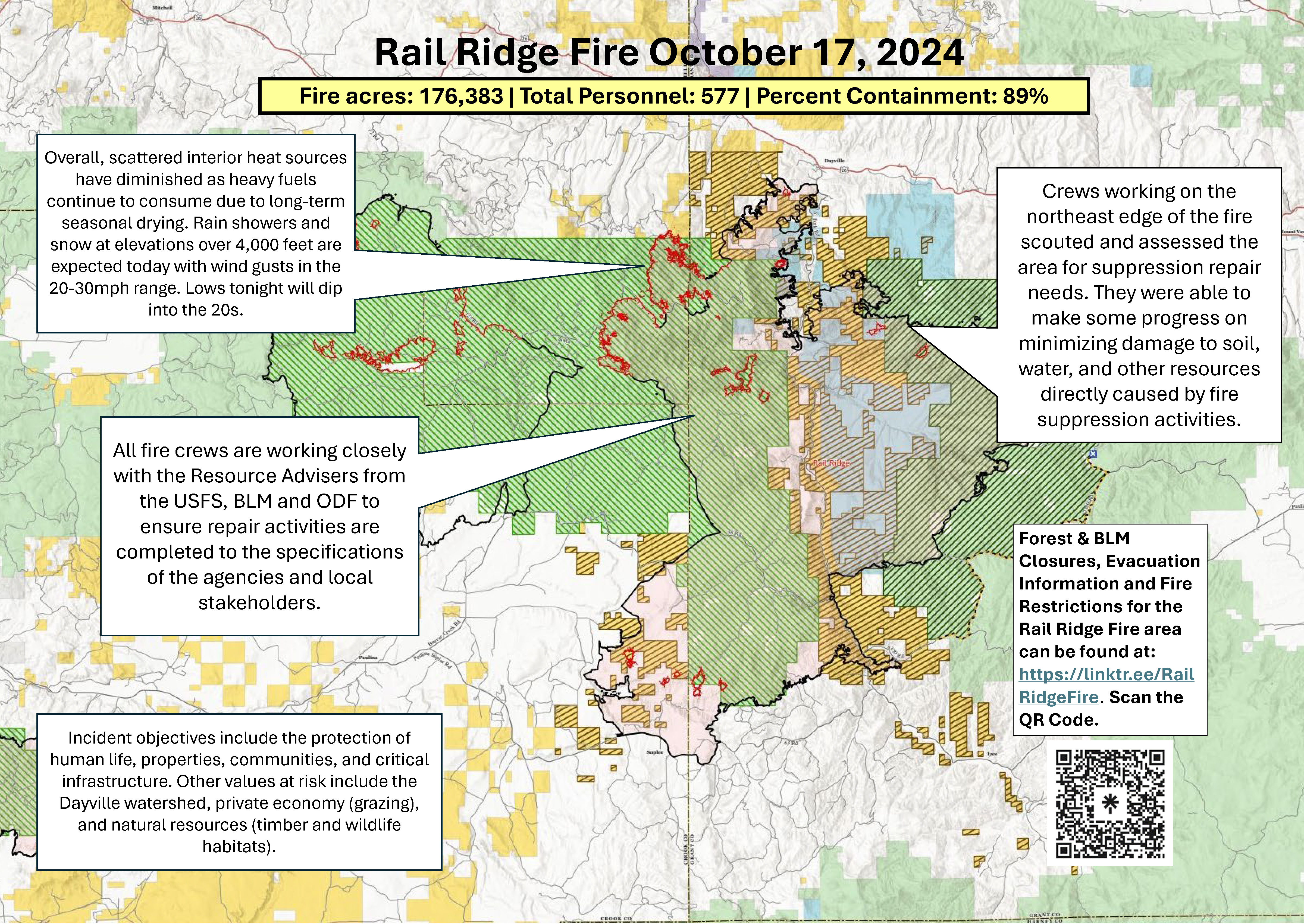
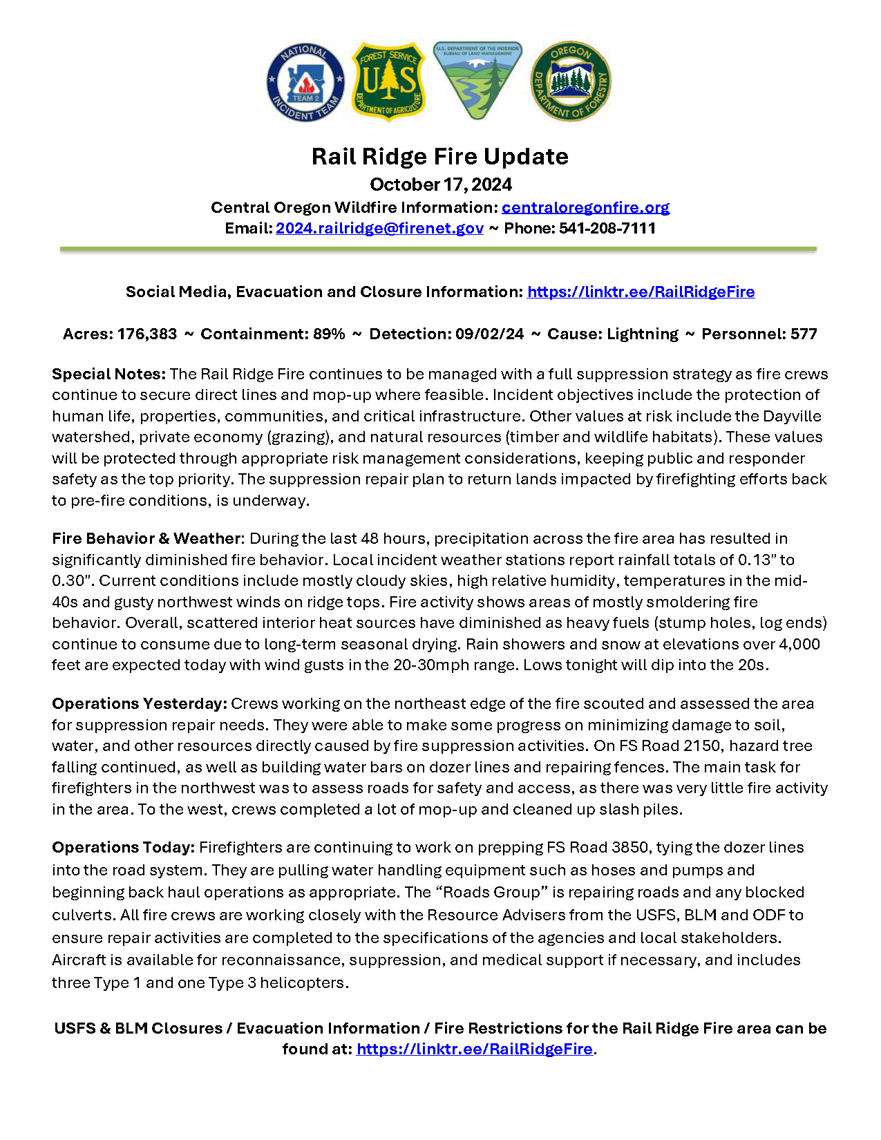
Rail Ridge Fire Update
Thursday October 17, 2024
Central Oregon Wildfire Information: centraloregonfire.org
Email: 2024.railridge@firenet.gov – Phone: 541-208-7111
Social Media, Evacuation and Closure Information: https://linktr.ee/RailRidgeFire
Acres: 176,383 – Containment: 89% – Detection: 09/02/24 – Cause: Lightning – Personnel: 577
Special Notes: The Rail Ridge Fire continues to be managed with a full suppression strategy as fire crews continue to secure direct lines and mop-up where feasible. Incident objectives include the protection of human life, properties, communities, and critical infrastructure. Other values at risk include the Dayville watershed, private economy (grazing), and natural resources (timber and wildlife habitats). These values will be protected through appropriate risk management considerations, keeping public and responder safety as the top priority. The suppression repair plan to return lands impacted by firefighting efforts back to pre-fire conditions, is underway.
Fire Behavior & Weather: During the last 48 hours, precipitation across the fire area has resulted in significantly diminished fire behavior. Local incident weather stations report rainfall totals of 0.13" to 0.30". Current conditions include mostly cloudy skies, high relative humidity, temperatures in the mid-40s and gusty northwest winds on ridge tops. Fire activity shows areas of mostly smoldering fire behavior. Overall, scattered interior heat sources have diminished as heavy fuels (stump holes, log ends) continue to consume due to long-term seasonal drying. Rain showers and snow at elevations over 4,000 feet are expected today with wind gusts in the 20-30mph range. Lows tonight will dip into the 20s.
Operations Yesterday: Crews working on the northeast edge of the fire scouted and assessed the area for suppression repair needs. They were able to make some progress on minimizing damage to soil, water, and other resources directly caused by fire suppression activities. On FS Road 2150, hazard tree falling continued, as well as building water bars on dozer lines and repairing fences. The main task for firefighters in the northwest was to assess roads for safety and access, as there was very little fire activity in the area. To the west, crews completed a lot of mop-up and cleaned up slash piles.
Operations Today: Firefighters are continuing to work on prepping FS Road 3850, tying the dozer lines into the road system. They are pulling water handling equipment such as hoses and pumps and beginning back haul operations as appropriate. The “Roads Group” is repairing roads and any blocked culverts. All fire crews are working closely with the Resource Advisers from the USFS, BLM and ODF to ensure repair activities are completed to the specifications of the agencies and local stakeholders. Aircraft is available for reconnaissance, suppression, and medical support if necessary, and includes three Type 1 and one Type 3 helicopters.
USFS & BLM Closures / Evacuation Information / Fire Restrictions for the Rail Ridge Fire area can be found at: https://linktr.ee/RailRidgeFire.
Garden and Red Rock Fires Update 10 17 2024
Related Incident:
Publication Type: News
Closure Orders reduced for Garden and Red Rock fires
Red Rock Fire
Operations: Yesterday, fire operations focused on addressing any areas of concern ahead of the cold front. Ignitions continued around the Williams Creek Summit to close off the northeast corner of the fire. Machinery and crews continued to remove fuels along the Ridge Road south to Lake Mountain. The fire in Salt Creek was very active, but burned towards the old Salt Creek burn scar where it is expected to moderate. Crews built direct line in Forth of July Creek and Moyer Creek. Helicopters were used to cool down hot spots on the interior of the fire. Mop up continued on the spot fire in Napias Creek.
Today, crews will see what the change in weather provided. Aircraft will assess all areas of the fire to determine what additional actions are needed. Crews will continue vegetation removal south along the Ridge Road and any necessary direct line construction in Forth of July Creek and Moyer Creek. Any remaining heat from yesterday’s ignitions near Williams Creek Summit will be mopped up. The need for additional ignitions will be assessed.
Garden Fire
Operations: Yesterday resources continued to patrol and mop up the fire’s edge. Due to the fire’s location, how it initially burned and difficulty accessing, mop up may take time. However, today the crews will assess the effects of the weather helping to meet the objective to keep the Salmon River and Panther Creek secure.
Additional Information
Weather: An approaching cold front is expected to bring stronger wind and a wind shift to the northwest on Thursday, rainfall and snowfall with likely wetting rains of more than 0.10 of an inch, and low temperatures from the upper 20s to around 40. Humidity is expected to be much higher, staying above 45 percent. Precipitation will taper off Thursday late night, but cold temperatures and cloudy skies will continue.
Smoke: For smoke information, please go to: https://www.airnow.gov/education/what-you-can-do/, or https://outlooks.airfire.org/outlook/ded7837a
Closures: The Salmon‐Challis National Forest has implemented a separate and reduced Red Rock and Garden Fire Closure, Order Number: 04‐13‐24‐027 and Order Number 04-13-24-028, effective as of 8:00 pm, Wednesday, October 16, 2024. https://www.fs.usda.gov/alerts/scnf/alerts-notices
Safety: A Temporary Flight Restriction (TFR) is in place over the Red Rock and Garden fire areas, which includes uncrewed aircraft systems or drones. Reminder that if you fly we can’t, unauthorized drone flights pose serious risks to firefighter and public safety and the effectiveness of wildfire suppression operations.
Please stay out of the fire area. There is still active fire behavior in the fire area, including group torching and crown runs. There are multiple roads and bridges that have been destroyed or are impassable. Entry into evacuation zones that are in “Go” status is prohibited. The updated forest closure notice that encompasses both the Red Rock Fire and Garden Fire areas includes multiple road and area closures. Barricade closures will be posted at road intersections and forest boundaries.
Evacuations: For evacuation information in Lemhi County regarding both the Red Rock and Garden fires please go to: https://www.lemhicountyidaho.org/emergency-management-department.
.jpg?VersionId=WvF.X.7pRjxbJ9AFn4OfyUGol7MJoHUi)
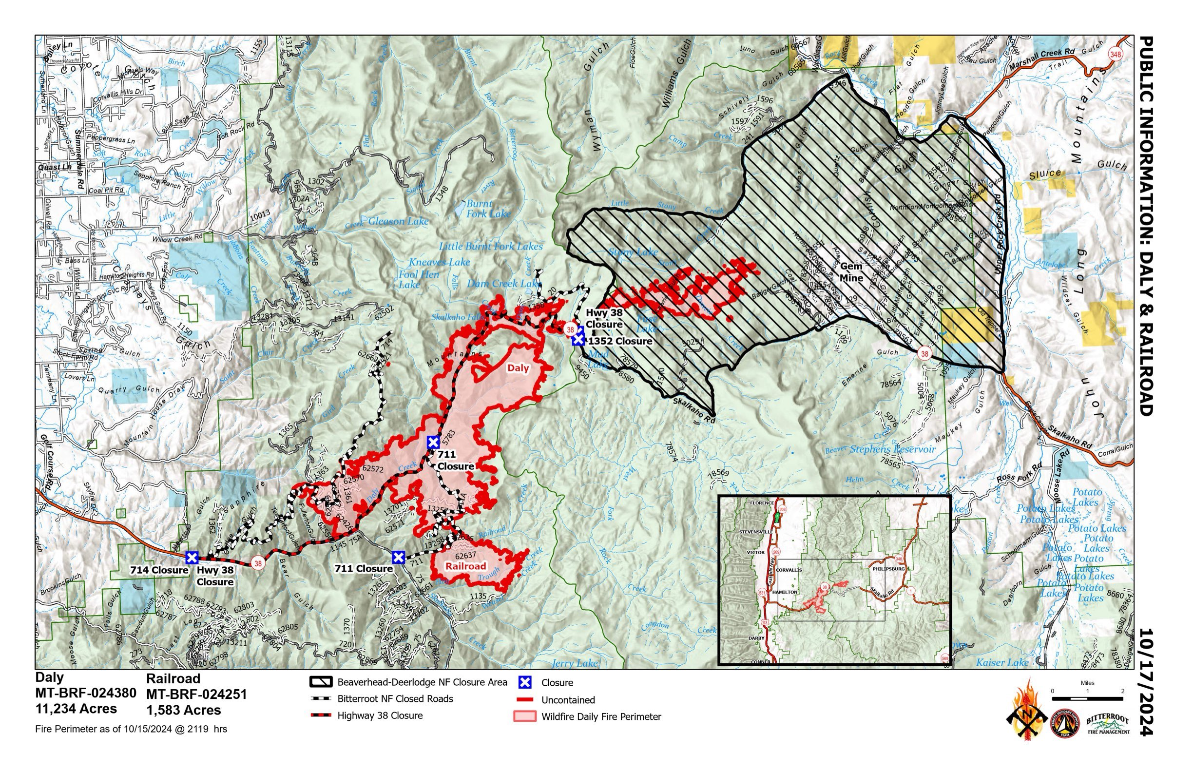
RailroadDaly Fire Update 10 17 2024
Related Incident:
Publication Type: News
Type 3 Incident, Incident Commander Justin Abbey, ICT3 Trainee: Chris Kramer
Location: Bitterroot NF: Railroad Creek/ Skalkaho Creek confluence, 26 miles southeast of Hamilton. Beaverhead-Deerlodge NF: 20 Miles northwest of Georgetown Lake Dam off Skalkaho Hwy 38
Start Date: 7/25/2024
Cause: Undetermined
Daly Fire Acres: 11,234 Railroad Fire Acres: 1,583 Completion: 56% Total Personnel: 185
Current Status : Yesterday cooler temperatures over the fire provided minimal fire activity and growth. Firefighters continued holding and monitoring previous burn operations. The shaded fuel break has been completed along the coal creek road. Sawyers progressed along Skalkaho Hwy 38 cutting standing dead trees and used a woodchipper to shred tree limbs and burned ground debris. Last night the east side of the fire received snow levels at 7,000 feet elevation, fire activity in this area remains minimal. The fire did not receive an infrared flight last night so acreage will remain the same as yesterday.
Today, crews will continue holding and monitoring fires edge on Buckhorn Saddle. Sawers will continue clean up above Skalkaho Hwy 38. Aerial resources are available to the crews as needed. Fire Management will discuss and develop a suppression repair plan on both the Beaver-Head Deerlodge & Bitterroot National Forests.
Weather and Fire Behavior : As the cold front remains over the fire, it will bring increased westerly wind of 5-15mph. Rainy conditions will increase relative humidities up to 63-68%. Tonight, will be mostly cloudy and a slight chance of snow in the evening. Thursday will be cooler showing lows in the morning to get into mid 20s and daytime highs to the mid 30s. Clear skies expected Friday.
EVACUATIONS: On October 9, 2024 the Ravalli County Sheriff’s Office issued an Evacuation Warning for residents off of Skalkaho Highway (1700-2500 block) due to the Railroad-Daly Fire. For more information on evacuations visit the Ravalli County Sheriff Facebook page. To register your phone number for emergency notifications in Ravalli County visit, http://hyper-reach.com/mtravallisignup.html.
CLOSURES : The Beaverhead-Deerlodge National Forest has issued an Area/Road/Trail Closure effective October 4, 2024. The Bitterroot National Forest has also issued a road closure effective October 10, 2024. These orders are for public and firefighter safety during fire suppression efforts on the Fire.
Closure information and maps are posted on the Bitterroot and Beaverhead-Deerlodge National Forests’ website www.fs.usda.gov/alerts/bdnf/alerts-notices and www.fs.usda.gov/alerts/bitterroot/alerts-notices.
BAER Archaeologists assess historic cultural resources for Goat and Snag wildfires 10 17 2024
Related Incident: Boise NF Post-Fire BAER 2024
Publication Type: News
BAER Archaeologists assess historic cultural resources for Goat and Snag wildfires
Burned Area Emergency Response (BAER) Archaeologists Nathan Gabriel and Sarah Herrera recently evaluated cultural resources within burn areas of the Snag Fire for the Boise National Forest BAER assessment team.
As they were surveying heritage cultural resources located near Stoney Meadows within the Snag Fire and includes a historic warming hut, fire crews at nearby Stolle Meadows were busy prepping multiple structures in anticipation of the Goat Fire burning through the area. Fire managers were concerned that current fire behavior could burn the historic structures located at Stolle Meadows.
With BAER archaeologists Gabriel and Herrera assessing BAER cultural resources within the Snag Fire perimeter, the threatening fire situation from the nearby Goat Fire made it even more important to assess for post-fire threats--and they were there “before” the Goat Fire could potentially hit the Stolle Meadows area.
Fire suppression wrapping of the historic structures and the placement of water sprinklers provided protection to Stolle Meadows for the possibility that the Goat Fire burns through the area. When historic structures survive burning from wildfires, and BAER specialists assess burn areas for post-fire threats from future rain events such as flooding and debris flows, preemptive suppression work can protect cultural resources so that they are not destroyed and can be later be evaluated.
Because BAER teams assess post-fire conditions, these BAER specialists anticipate these cultural resources will survive burning thanks to pre-planning and firefighter efforts, with the hope that fire is not too severe so that future recreationists can enjoy these beautiful meadows and both historic sites during their future visits to the Boise National Forest.
NOTE: See related photos to this article under the “Photos” Tab on this Boise NF Post-Fire BAER InciWeb page: Idbof Boise Nf Postfire Baer 2024 Information | InciWeb (wildfire.gov). Also see “Related Information” PDF article document containing related article photos below.
BAER SAFETY MESSAGE: Everyone near and downstream from the burned areas should remain alert and stay updated on weather conditions that may result in heavy rains and increased water runoff. Flash flooding may occur quickly during heavy rain events—be prepared to act. Current weather and emergency notifications can be found at the National Weather Service: www.weather.gov/boi/.
###
Nevada Lake Fire Update 10 17 2024
Related Incident:
Publication Type: Announcement
Location: 8 miles east of Helmville, MT, 0.5 miles north of Nevada Lake
Start Date: 10/14/2024
Cause: Escaped Prescribed Burn
Size: 208 acres
Containment: 0%
124 Total Personnel; 12 Engines; 2 Helicopters; 2 Hand Crews; 4 Heavy Equipment
CURRENT STATUS
The Nevada Lake Fire is currently 208 acres and actively burning in open grass and heavy timber on the Fish, Wildlife and Parks (FWP) Nevada Lake Wildlife Management Area (WMA) and private land east of Helmville, Montana. The wildfire is the result of a FWP escaped prescribed burn ignited on Monday, October 14, north of Nevada Lake on the WMA. The burn was declared a wildfire when the prescribed fire escaped containment lines. The DNRC is managing the wildfire response.
On Wednesday, October 16, resources completed line construction around the majority of the fire perimeter and began “mop up” operations, or extinguishing all heat and hot spots close to the line to better secure it. Today, efforts will focus on building control line and reinforcing existing control line, with helicopters providing air support as needed. The fire remains at 0% containment, with containment measuring how much of the fire perimeter has been surrounded by control line that managers are confident fire will not progress across.
Several days of work are anticipated to secure unburned areas of fuel within the fire perimeter and complete mop-up operations in burned sections near the control lines.
WEATHER AND FIRE BEHAVIOR
Today, the area will receive scattered showers and cooler temperatures due to a low-pressure system. There is a 20 percent chance of wetting rains with 5-15 mph winds out of the west. High pressure will build back over the area Friday and into the weekend allowing for gradual warming and drying conditions. More shower activity is expected for Monday.
EVACUATIONS AND CLOSURES
There are no evacuations or closures, but the public is asked to avoid the area. Area residents should be vigilant and remain prepared. For updates, visit https://inciweb.wildfire.gov/incident-information/mtmts-nevada-lake-fireand monitor the Powell County Sheriff's Office Facebook page.
For tips on being prepared for wildfire, please visit https://www.mtfireinfo.org/pages/preparedness.
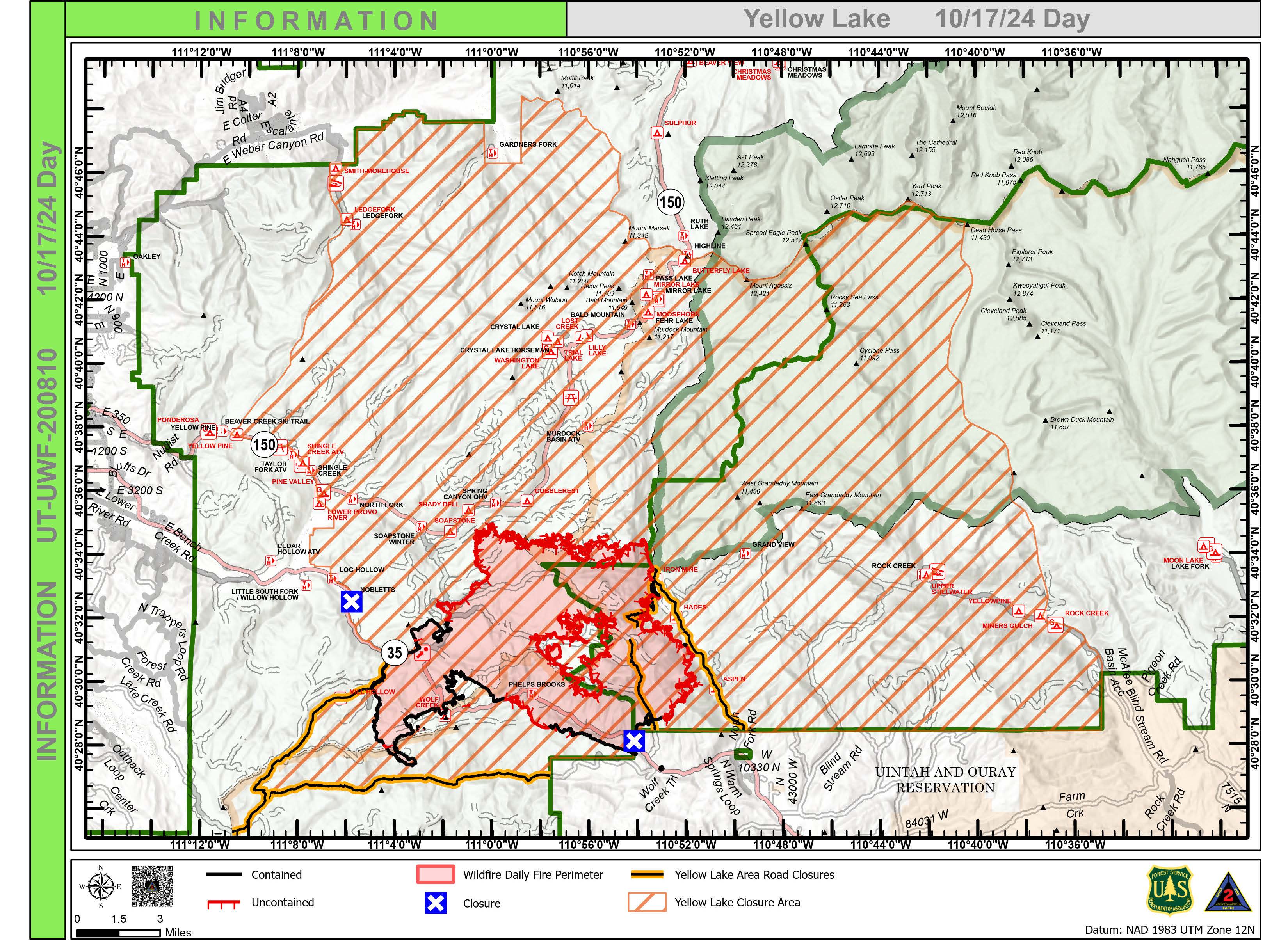
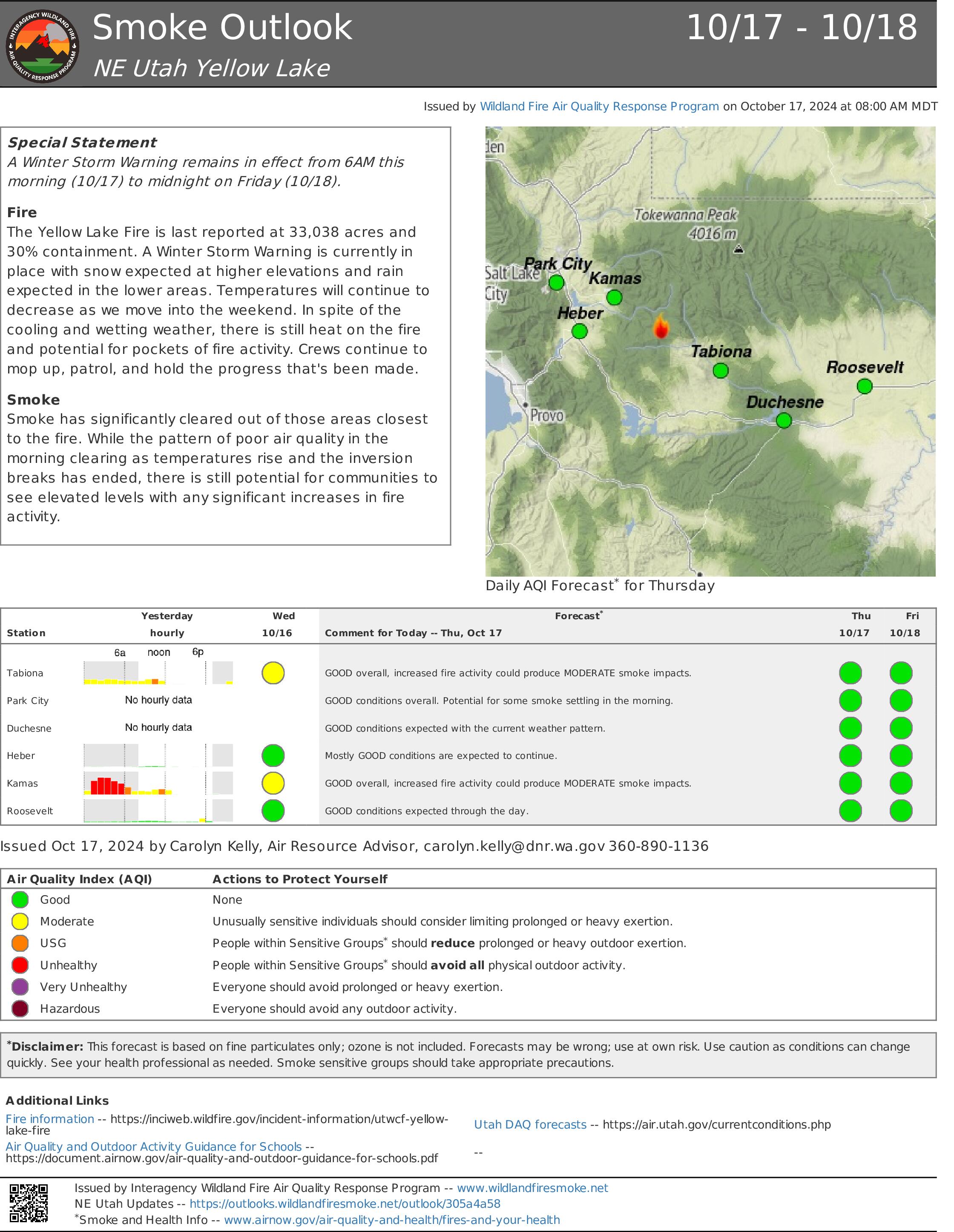
Yellow Lake Fire Update 10 17 2024
Related Incident: Yellow Lake Fire
Publication Type: News
Yellow Lake Fire
Incident Update October 17, 2024
Size at time of update: 33,038
Containment: 30%
Personnel: 779
Start: Saturday, September 28, 2024
Cause: Human Caused (Under Investigation)
Location: 10 miles southeast of Francis, Utah
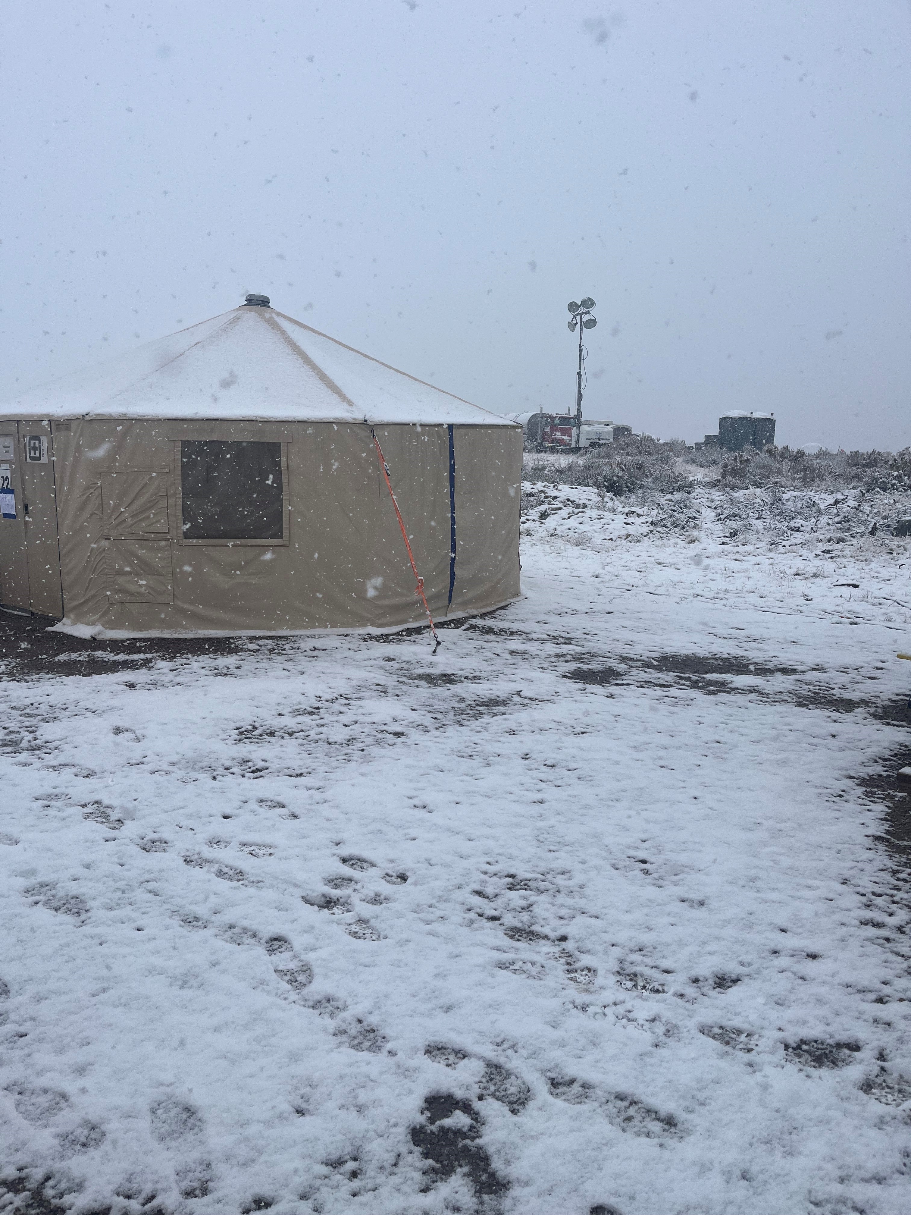
No reportable fire behavior occurred overnight on the Yellow Lake Fire. Occasional single tree torching and other heavy fuel smoke is expected to continue within the fire perimeter.
Fire crews were pulled off the line yesterday afternoon as a storm system passed through. Minimal rainfall and hail were reported over portions of the fire area. Scattered showers and possible thunderstorm activity are expected today at lower elevations. Snow is predicted at elevations ranging from Wolf Creek Summit up to Bald Mountain Pass.
As weather permits, crews will continue to back haul equipment such as pumps and hoses. They are cautioned to be aware of falling snag potential due to precipitation.
Operational tactics have primarily shifted from direct suppression to rehabilitation. Dozer lines are being groomed and upgraded with water bars to restore natural water flow. Handlines are also being improved to support proper drainage. Crews are ensuring existing culverts and water pathways on the south end of the fire perimeter are free and clear of obstructions.
Crews will not be on the line tonight due to decreased fire activity and incoming weather. Very cold temperatures are predicted throughout the weekend.
Area residents may have noticed a burned fire vehicle being towed from the fire area yesterday. Last week, during very active fire behavior, a parked truck was engulfed by flames on the east side of the fire. Firefighters were not in the immediate vicinity of the truck at the time, and no one was injured.
Community meetings are scheduled on Saturday at 4:00 p.m. in Kamas and on Sunday at 4:00 p.m. in Tabiona to discuss transitioning the fire back to local Forests. Additional details will be announced.
All evacuation orders and closures remain in effect.
Forest Closures:
- Updated October 11, 2024, a closure has been increased on the Uinta-Wasatch-Cache National Forest due to the Yellow Lake Fire. This Order shall remain in effect until October 31, 2024, unless rescinded.
https://www.fs.usda.gov/Internet/FSE_DOCUMENTS/fseprd1208350.pdf
- Updated October 11, 2024, a closure has been increased on the Ashley National Forest due to the Yellow Lake Fire. This closure will remain in place through December 31, 2024, or until rescinded, for public safety.
Evacuation Areas: The North and West Forks of the Duchesne River, and Granddaddy Lakes area are under a mandatory GO evacuation meaning all residents, hunters, and recreationists must leave and stay out of the area. Hanna is under a SET order, advising residents to have bags packed and be prepared to evacuate if necessary.
For updated evacuation zones, please visit:
https://emergency-management-operations-wasatch.hub.arcgis.com/
https://tricountyemergencyalert.genasys.com/portal/en
https://www.fs.usda.gov/Internet/FSE_DOCUMENTS/fseprd1208878.pdf