
Sheep Creek Fire Closures Rescinded 10 18 2024
Related Incident: Sheep Creek
Publication Type: Closures
Rescinding Order
Beaverhead-Deerlodge NF
Pursuant to Title 36, Code of Federal Regulation 261.50 (a) & (b), the prohibition listed in Order Number 01-002-04-24-18, applicable to the Beaverhead-Deerlodge NF, dated October 3, 2024 and signed by Alfred Watson, Forest Supervisor, is hereby rescinded, effective October 18, 2024 at 11:59 p.m.
Nevada Lake Fire Update 10 18 2024
Related Incident:
Publication Type: Announcement
Location: 8 miles east of Helmville, MT, 0.5 miles north of Nevada Lake
Start Date: 10/14/2024
Cause: Escaped Prescribed Burn
Size: 208 acres
Containment: 10%
79 Total Personnel; 5 Engines; 2 Helicopters; 2 Hand Crews; 3 Heavy Equipment
CURRENT STATUS
The Nevada Lake Fire is currently 208 acres and burning in open grass and heavy timber on the Fish, Wildlife and Parks (FWP) Nevada Lake Wildlife Management Area (WMA) and private land east of Helmville, Montana. The wildfire is the result of a FWP escaped prescribed burn ignited on Monday, October 14, north of Nevada Lake on the WMA. The burn was declared a wildfire when the prescribed fire escaped containment lines. The DNRC is managing the wildfire response.
On Thursday, October 17, resources completed line construction around the fire perimeter and continued “mop up” operations, or extinguishing all heat and hot spots close to the line to better secure it. Today, efforts will focus on reinforcing control line, with helicopters providing air support as needed. The fire is 10% contained, with containment measuring how much of the fire perimeter has been surrounded by control line that managers are confident fire will not progress across.
Several days of work are anticipated to secure unburned areas of fuel within the fire perimeter and complete mop-up operations in burned sections near the control lines.
WEATHER AND FIRE BEHAVIOR
The fire did receive rain on Thursday which helped dampen fire behavior and aided firefighters as they worked to increase fire containment. Gradual warming and drying will occur today and into the weekend, accompanied by variable winds less than 10 mph. Cooler temperatures and scattered showers are expected for Monday.
EVACUATIONS AND CLOSURES
There are no evacuations or closures, but the public is asked to avoid the area. Area residents should be vigilant and remain prepared. For updates, visit https://inciweb.wildfire.gov/incident-information/mtmts-nevada-lake-fireand monitor the Powell County Sheriff's Office Facebook page.
For tips on being prepared for wildfire, please visit https://www.mtfireinfo.org/pages/preparedness.
October 21 2024 UpdatePile Burning Activities in the Crazy Mountains Postponed 10 18 2024
Related Incident: 2024 Custer Gallatin National Forest Prescribed Fire Program
Publication Type: News
October 21, 2024 Update: Pile burning activities in the Crazy Mountains are postponed due to drier than expected conditions and high winds.
Depending on weather conditions, pile burning activities may begin as soon as October 21st in the northwestern Crazy Mountains, specifically in the Smith Creek and Sunlight Road areas. The Crazy Mountains are located north of Livingston, MT. The piles to be burned are part of the Smith Shields Forest Health project and are a result of thinning to improve forest health and reduce fuels to moderate fire intensity along key corridors. Smoke and flames may be visible, please do not report.
Shoe Fire Daily Update for 10 18 2024
Related Incident: Shoe Fire
Publication Type: News
Email: 2024.shoe@firenet.gov
Incident Website: https://inciweb.wildfire.gov/incident-information/cashf-shoe-fire
Forest Website: https://www.fs.usda.gov/stnf
Fire Weather Forecast: https://www.weather.gov/wrh/CAFW?area=ECC005
Fire Information: 530-338-0317 Media Line: 909-855-4233 Hours: 08:00am to 8:00pm
Location: Shasta County, CA Start Date: Wednesday, October 9, 2024, at 6:57 p.m.
Cause: Human caused Size: 4,186 acres
Percent Contained: 8% Vegetation: Timber, Chapparal
Number of Personnel Assigned: 1,333
A red flag warning is currently in effect today until Saturday afternoon. Ground crews have been engaged in reinforcing existing containment lines through use of dozers and hand crews. Overall fire conditions have shown improvement; overnight infrared readings have shown less heat and minimal growth from the previous day. Additional resources continue to arrive to provide further support. Structural assessment teams are actively evaluating risks to residential properties along the Fenders Ferry corridor. A mobile retardant base has been established in Big Bend. These mobile retardant bases function as portable facilities that mix and store fire retardant, thereby enhancing aerial firefighting operations if needed.
WEATHER: Strong north to northeast winds will continue to bring gusty winds today through Saturday morning. Strong winds are expected this morning with wind gusts reaching up to 40mph. Downslope winds will have a stronger drying effect on surrounding fuels causing a faster drop in humidity levels.
EVACUATIONS: Mandatory evacuations remain in place for zone LKH-1448-B. Residents who have not evacuated are encouraged to do so. Evacuation information and alerts can be found by visiting protect.genasys.com
Information staff for the Shoe Fire are working diligently to provide timely and accurate information to the public. Fire updates can be found on the Shoe Fire 2024 Facebook page: www.facebook.com/2024ShoeFire/
FIRE AND SMOKE MAP:
Updates on smoke conditions can be found under the following link
https://outlooks.wildlandfiresmoke.net/outlook/59ecb6c0?
ROAD CLOSURES:
- Fenders Ferry Road at Pit River 7 Bridge: West-Bound Fenders Ferry Road (Also known as 34N17 - Forest Service Road 27) at the Pit River Bridge/Pit 7
- Ferry Road is closed at McCloud Bridge: East-Bound Fenders Ferry Road at the McCloud River Bridge
FOREST CLOSURES:
https://www.fs.usda.gov/detailfull/stnf/alerts-notices/?cid=stelprdb5392380
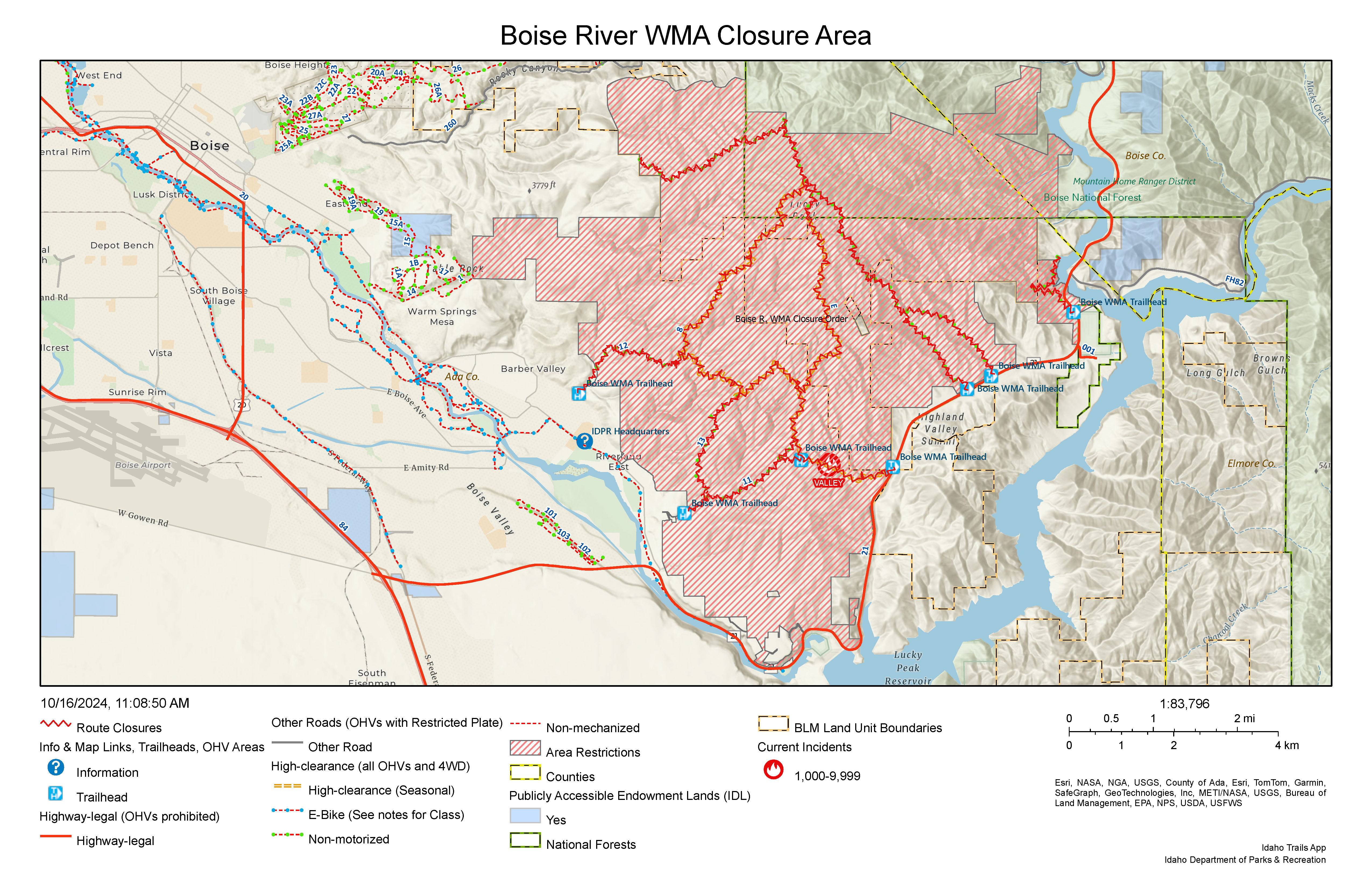
Valley Fire Update 10 18 2024
Related Incident: 2024 Valley Fire
Publication Type: News
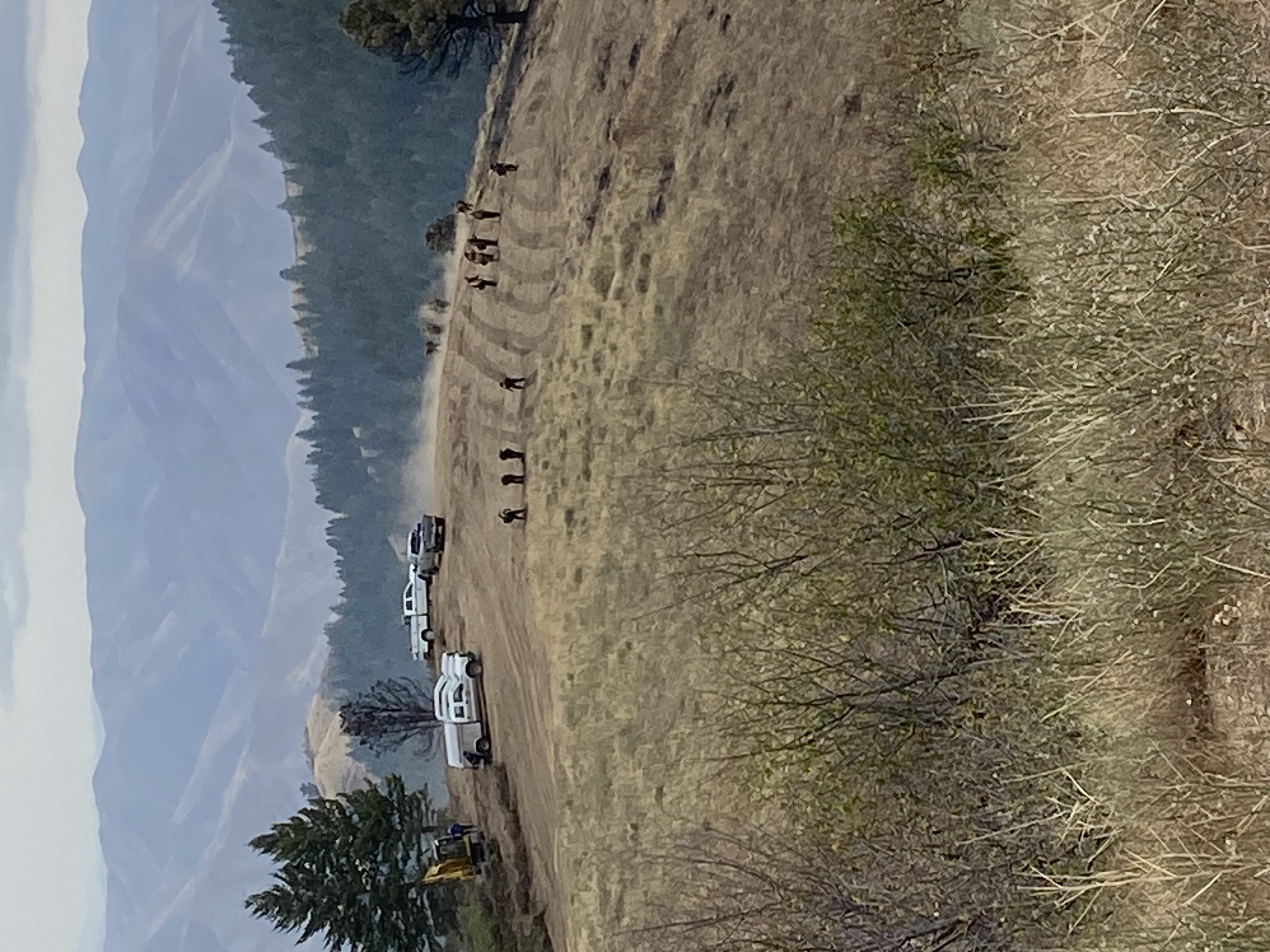
Incident Activity: Fire crews continue to be located at the Valley Fire Incident Command/Fire Camp sleeping in tents and continue to get an early start with overnight temperatures below freezing. Rapid progress is being made on repairing the impacts of firefighting. All efforts are now going to suppression repair thanks to success in addressing hot spots near the Robie Creek area and securing containment lines. Some smoke is still visible in the fire interior but is not a threat to containment. There are 33 miles of dozer line as well as hand line that crews are working to restore to a more natural state. More than a dozen miles are completed with some locations already seeded for regrowth. Please honor trail closures for firefighter and public safety. Crews and heavy equipment are active in the fire area.
Closures Remain in Effect for Public and Firefighter Safety: All roads and trails on the Boise Front segment of the Boise River WMA west of Highway 21 and north of Warm Springs Avenue remain closed to all entry until further notice. This closure also extends to all travel off roads and trails. The public is asked to please honor closure signs at trailheads even if fire activity is not visible. Members of the public have been recreating in closed areas. This poses a safety risk to the public and fire crews.
Evacuation Status Lifted: The Robie Creek community is released from evacuation readiness. There are no further areas in Boise County that are under evacuation readiness recommendations.
Weather: Continued lower temperatures in the Valley Fire area with highs averaging in the mid-50s with minimal precipitation.
Valley Fire Overview: The fire was reported Friday, October 4, 2024, about 1 mile east of Boise on the north side of Idaho State Highway 21. The fire was very visible from East Boise as it burned in mostly grassy fuels in the Boise Foothills. Quick work on initial attack stopped the fire from reaching nearby homes. The current fire cost estimate is $3.9 million.
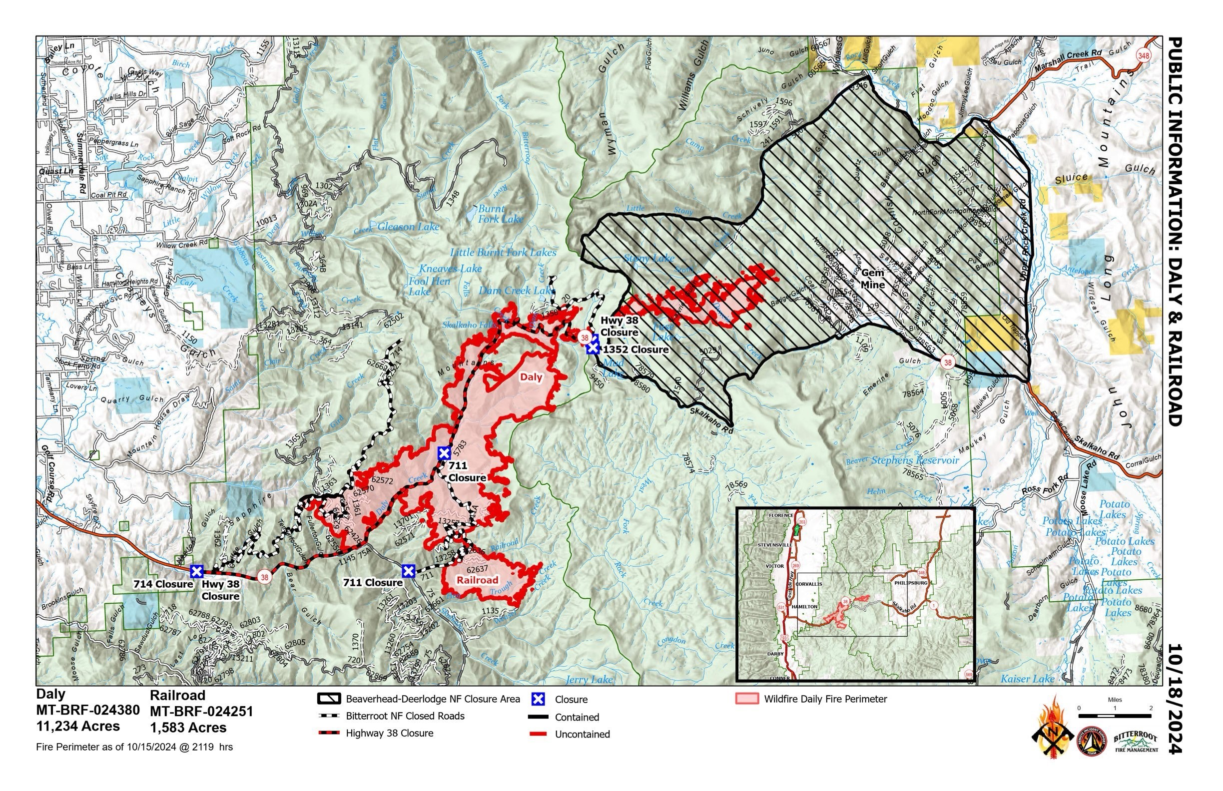
RailroadDaly Fire Update 10 18 2024
Related Incident:
Publication Type: News
Type 3 Incident, Incident Commander Justin Abbey, ICT3 Trainee: Chris Kramer
Location: Bitterroot NF: Railroad Creek/ Skalkaho Creek confluence, 26 miles southeast of Hamilton
Beaverhead-Deerlodge NF: 20 Miles northwest of Georgetown Lake Dam off Skalkaho Hwy 38
Start Date: 7/25/2024
Cause: Undetermined
Daly Fire Acres: 11,234 Railroad Fire Acres: 1,583 Completion: 58% Total Personnel: 178
Current Status : Yesterday’s snow and rain showers provided cooler temperatures and contributed to minimal fire activity. Firefighters continued holding and monitoring previous burn operations. Sawyers progressed along Skalkaho, minimizing the amount of standing dead tress above Hwy 38. Chipping operations continued as well.
Today, crews will continue holding and monitoring fires edge on Buckhorn Saddle. Sawers will continue clean up above Skalkaho Hwy 38. Aerial resources are available to the crews as needed. Fire Management will continue developing a suppression repair plan on both the Beaverhead-Deerlodge & Bitterroot National Forests.
Weather and Fire Behavior : Today is forecast to be mostly sunny, max temperature to be 35-40 degrees with light and variable winds. A low amplitude ridge of high pressure expected to build back over the fire area into the weekend allowing for gradual warming and drying conditions. Another disturbance is expected for Monday bringing more shower activity.
EVACUATIONS: On October 9, 2024 the Ravalli County Sheriff’s Office issued an Evacuation Warning for residents off of Skalkaho Highway (1700-2500 block) due to the Railroad-Daly Fire. For more information on evacuations visit the Ravalli County Sheriff Facebook page.
To register your phone number for emergency notifications in Ravalli County visit, http://hyper-reach.com/mtravallisignup.html.
CLOSURES : The Beaverhead-Deerlodge National Forest has issued an Area/Road/Trail Closure effective October 4, 2024.
The Bitterroot National Forest has also issued a road closure effective October 10, 2024.
These orders are for public and firefighter safety during fire suppression efforts on the Fire.
Closure information and maps are posted on the Bitterroot and Beaverhead-Deerlodge National Forests’ website www.fs.usda.gov/alerts/bdnf/alerts-notices and www.fs.usda.gov/alerts/bitterroot/alerts-notices.
WYDOT Temporary I90 Closure Between Acme WY and Wyola MT 10 17 2024
Related Incident: Elk Fire 2024
Publication Type: Closures
WYDOT to temporarily close I-90 between Acme and Wyola Montana– detours available
Sheridan, Wyo – The Wyoming Department of Transportation (WYDOT) and Montana Department of Transportation (MDT) have rescheduled the closing of Interstate 90 between Acme Wyoming and Wyola Montana to Monday, October 21, 2024, for the aerial spraying of this stretch of the I-90 corridor for noxious weeds.
The closure will begin at 7:00 a.m. and will open once spraying is complete – an estimated eight hours. The closure is weather dependent, with Tuesday, October 22 as an alternative date if weather aborts the flight.
MDT will close I-90 at the Wyola, MT Exit 544 and detour eastbound traffic to MT451 and WYO345 through Parkman and Ranchester to the Acme Interchange at Exit 14.
WYDOT will close I-90 at the Acme, WY Exit 14 and detour westbound traffic onto WYO 345 through Parkman to Wyola, MT Exit 544.
Motorists should anticipate potential delays of up to fifteen minutes and an additional thirty minutes of travel time due to heavy traffic and reduced speed limits.
All exits along I-90 within the closure area, including all county and private roads, will be closed to traffic.
A twelve-foot width restriction, and 14’9” height restriction for westbound traffic, will be in place.
Interstate 90 has a severe infestation of ventenata and medusahead in the right-of-way, which serves as a seed source for nearby populations and significantly increases the risk of seed spread throughout the state.
Ventenata and medusahead are extremely damaging invasive species that choke out desirable grasses and can significantly decrease land value. Livestock and wildlife will not graze ventenata or medusahead and they can drastically increase wildfire risk. Both invasive grasses were first confirmed in Wyoming in 2016.
Sheridan County Weed and Pest (SCWP) will be applying an herbicide utilizing aerial spraying. Aerial application has proven to be the most effective method of applying this herbicide. To apply the herbicide, helicopters need to fly at an altitude of 30 feet above ground level and cannot make applications in proximity to live traffic.
Application by ground spraying equipment is less effective due to the precise and uniform dispersal of herbicide required.
MDT will participate and herbicide application will take place on a two-mile section north of the state line.
All total, 840 acres of right of way in Wyoming and 97 acres of right of way in Montana will be treated.
SCWP will use two herbicides containing indaziflam and imazapic. Both herbicides are approved by the EPA for use in areas grazed by livestock with no restrictions on grazing following application.
-wydot-
Photo: Medusahead and Ventenata growing in the right of way along I-90 in Sheridan County.
![]()
For information about this news release, contact WYDOT District 4 public relations specialist Laura Dalles at 307-674-2356 or laura.dalles@wyo.gov.
For the latest road conditions, visit www.wyoroad.info, call 5-1-1, or download the Wyoming 511 app.
Follow WYDOT District 4 on Facebook at www.facebook.com/WYDOT District 4-Northeast-Wyoming and Instagram at wydot_northeast_wyoming.
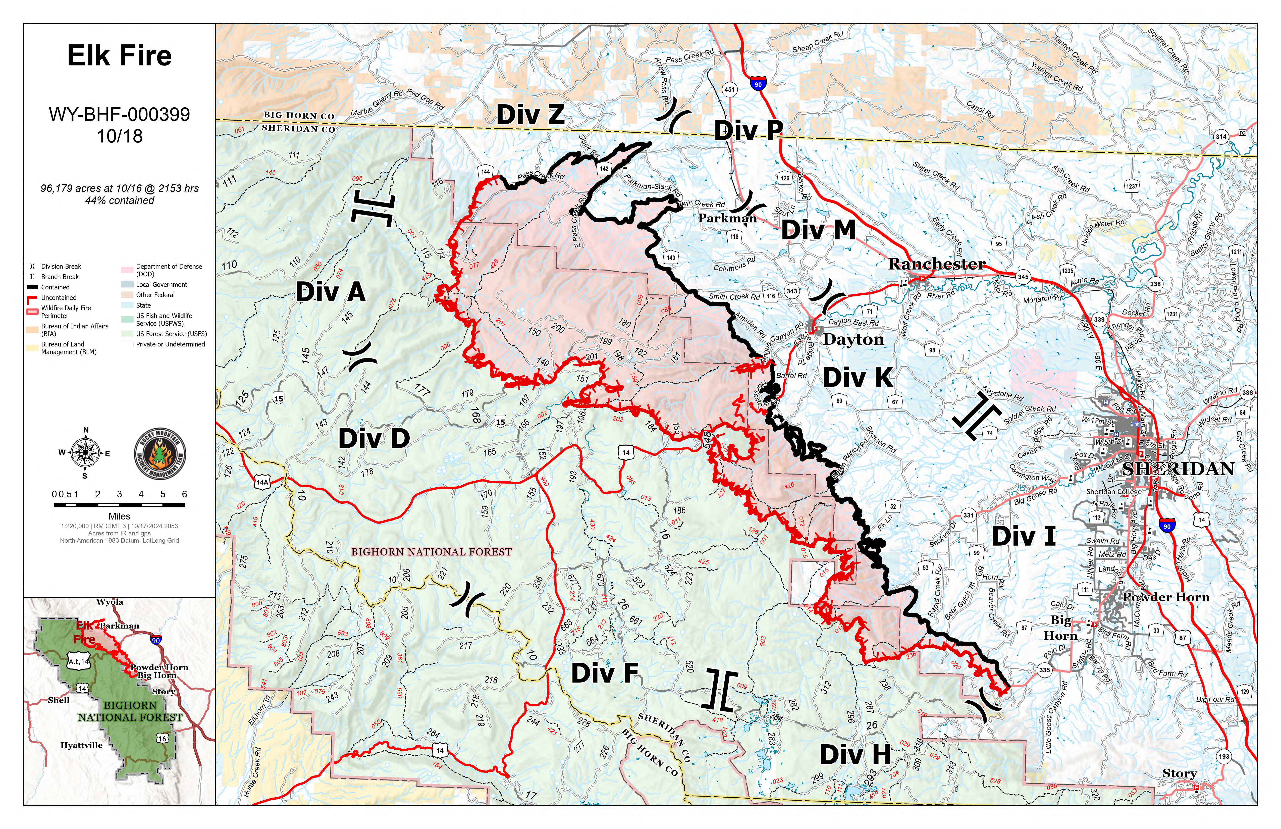
Elk Fire Update 10 18 2024
Related Incident: Elk Fire 2024
Publication Type: News
Elk Fire Update – October 18, 2024
Rocky Mountain Complex Incident Management Team 3
Incident Commander Casey Cheesbrough
Size: 96,179 acres (no change)
Total Personnel: 714
Containment: 44 percent
Cause: Lightning
Resources: 10 aircraft | 14 crews | 26 engines | 7 dozers | 16 water tenders | 2 masticators | 4 skidders | 5 feller bunchers 4 processors | 3 chippers
Key Messages: Both Sheridan County and Johnson County downgraded several evacuation statuses yesterday. For detailed information about the changes in Sheridan County, go to facebook.com/sheridancountysheriffwy. For Johnson County, go to facebook.com/JohnsonCoWYEMC.
Cabin owners along Red Grade Road will be allowed through the road closure today from 9 am to 5 pm to winterize their cabins. Additional opportunities may be available in the future as fire conditions allow. For detailed information on the requirements, go to Sheridan County Sheriff’s Office Facebook page: facebook.com/sheridancountysheriffwy.
Today at 6 p.m., after 18 days managing the Elk Fire, Rocky Mountain Complex Incident Management Team (CIMT) 3, under the leadership of Incident Commander Casey Cheesbrough, will transfer command of the incident to Rocky Mountain CIMT 1, under the leadership of Incident Commander Dan Dallas. Team 3 greatly appreciates the outpouring of support, generosity, and gratitude expressed by residents and communities affected by the fire.
Current Situation: Overnight, firefighters were housed at the Sheridan County Fairgrounds and Sheridan County Community College because of the ongoing winter-weather event. “This situation is pretty challenging and really dynamic with the inclement weather, but we will always be proactive with taking care of our firefighters,” said Casey Cheesbrough, Elk Fire incident commander.
The decision to put firefighters back on the fireline today will be evaluated throughout the day. Those crews assessing the fire and road conditions will do so from hard-surface roads to minimize damage to gravel and dirt roads and trails saturated with recent precipitation.
Weather & Fire Behavior: Cold temperatures, high relative humidity, and precipitation yesterday and through the night resulted in minimal fire behavior and no growth. The northern portion of the fire received approximately 1 inch of rain, and the southern side 0.7 inches. Areas above 7,000 feet in elevation received between 5 and 10 inches of snow. The winter weather advisory remains in effect until 6 pm today, bringing the possibility of additional precipitation before a short-duration warming, drying trend begins tomorrow. The soaking rain penetrated soils and vegetation, reducing fire behavior immediately and likely for several days; however, stumps and large pockets of dead and down trees will continue to produce smoke. For air-quality and smoke information, go to airnow.gov.
Evacuations and Closures: For information on Johnson County evacuations, go to Johnson County Emergency Management’s Facebook page: facebook.com/JohnsonCoWYEMC. For information on Sheridan County evacuations and road closures, go to the Sheridan County Emergency Management website: sheridancountywy.gov/newslist. You can also call the Sheridan County Sheriff’s Office (307-672-3455) or Sheridan County Emergency Management (307-752-2174). US Highway 14 is closed between Burgess Junction and Dayton. View the Wyoming Department of Transportation road-closure map here: wyoroad.info. Bighorn National Forest closure Order No. 02-02-06-24-08 is in effect. The order and map can be viewed here: fs.usda.gov/alerts/bighorn/alerts-notices.
Elk Fire Information:
Phone: 307-303-7642 (8 am to 8 pm) | Email: 2024.Elk@firenet.gov | Linktree: linktr.ee/2024ElkFire
Yellow Lake Fire Community Meetings October 19 20 10 18 2024
Related Incident: Yellow Lake Fire
Publication Type: Announcement
Yellow Lake Fire Community Meetings:
Saturday, October 19, 2024
4:00 PM
Kamas Middle School Auditorium
Sunday, October 20, 2024
4:00 PM
Tabiona School gymnasium at 4:00 p.m. Sunday.
These meeting will be streamed, if technology allows, on both the Ashley and Uinta-Wasatch-Cache National Forest's Facebook pages.
Daily Update October 18 2024 10 18 2024
Related Incident:
Publication Type: News
PACK TRAIL FIRE
Friday, October 18, 2024 Update
Fire Information Phone: 307-395-2351 | Email: 2024.Packtrail @firenet.gov
Total Acres: 89,186 Confined: 62% Total Personnel: 535
Operations – Yesterday, the Pack Trail Fire received precipitation which greatly moderated fire behavior. The fire activity is minimal, however large diameter dead and down logs, stumps, and slash will continue to smolder within the interior of the fire. On the south side, crews accessed Union Pass Road utilizing Utility Task Vehicles (UTV) to scout and contain the fire’s edge. On the west flank, firefighters removed pumps and gas from the field to prevent freezing. These items are being staged nearby and can be reimplemented quickly if the fire situation changes. Due to the precipitation and hazards associated with driving on icy and muddy roads, most crews will stay at camp today to complete preventative maintenance on their equipment. Crews with UTVs will patrol the fire area, mopping up around the perimeter, focusing on areas with fine fuels, such as meadows and sagebrush.
Safety – Despite the recent precipitation, Teton Interagency Fire Managers are maintaining the Very High Fire Danger Rating for Grand Teton National Park, the Bridger-Teton National Forest, the Shoshone National Forest, and the National Elk Refuge. This precipitation was not a fire season ending event. Due to wind, fuels will begin to rapidly dry out when the snow melts. Any spark can ignite fire which can grow rapidly into a major incident. Residents and visitors are urged to exercise extreme caution with fires or other possible ignition sources. Never leave your campfire unattended, even for a moment. Always ensure someone is watching it or extinguish it completely before leaving. Drown the fire with water, stir the ashes, and feel with the back of your hand to confirm it is cool.
Please use caution while driving these areas, especially on narrow secondary roads. Always expect to encounter fire vehicles and heavy equipment in and around the fire area. Check with WY-DOT for possible closures due to fire activity, especially if you are planning to travel on US-26 across the Continental Divide. Closures are not expected, but with active fire in the area checking status before travel is recommended.
“If you fly, we can’t.” Remember that flying a personal drone over a fire area during a temporary flight restriction is illegal and can be an extremely dangerous threat to both our aviators and firefighters on the ground.
Weather – A rain and snow mix fell at lower elevations overnight into this morning, while locations about 8,500 feet experienced 1-3 inches of snow. Today will be mostly cloudy with snow continuing until 1PM. The temperature will be 26-39 degrees with relative humidity’s between 53% and 67%. Winds from the northeast will remain gusty at 25 MPH. Warmer and drier weather will return over the weekend and continue into next week. To learn more about air quality, visit Fire.AirNow.Gov.
Evacuations – Brooks Lake Lodge, Pinnacle Cabins, Falls Camp, and Long Creek have been reduced to a Level 2 “Set” Evacuation Warning. Level 3 “Go” evacuation orders remain in effect for Lava Mountain Lodge and McKenzie Highland Ranch. The Dunoir Road Corridor has been reduced to a Level 1 “Ready” Evacuation Warning. See the Fremont County Emergency Management Facebook Page for alerts and updates. See the Teton County Emergency Management website updates and to sign up for emergency alerts through Everbridge.
Road Closures – The Union Pass Road is closed on the Pinedale Ranger District (BTNF) from Mosquito Lake to the Moon Lake Road on the Wind River District (SHO). Moon Lake Road is also closed.
Forest Closures - Closure Order #04-03-24-317 is in effect from October 14, 2024 at 12:00 p.m. through November 15, 2024 at 12:00 a.m. unless rescinded. This order supersedes previous orders, including #04-03-24-316, prohibiting the same or similar acts in the same described area.
For more information, visit: Facebook: USDA Forest Service - Bridger-Teton National Forest, USDA Forest Service - Shoshone National Forest Pack Trail Inciweb: https://inciweb.wildfire.gov/incident-information/wybtf-pack-trail-fire