
Yellow Lake Fire Update 10 18 2024
Related Incident: Yellow Lake Fire
Publication Type: News
Yellow Lake Fire
Incident Update October 18, 2024
Size at time of update: 33,038
Containment: 30%
Personnel: 632
Start: Saturday, September 28, 2024
Cause: Human Caused (Under Investigation)
Location: 10 miles southeast of Francis, Utah
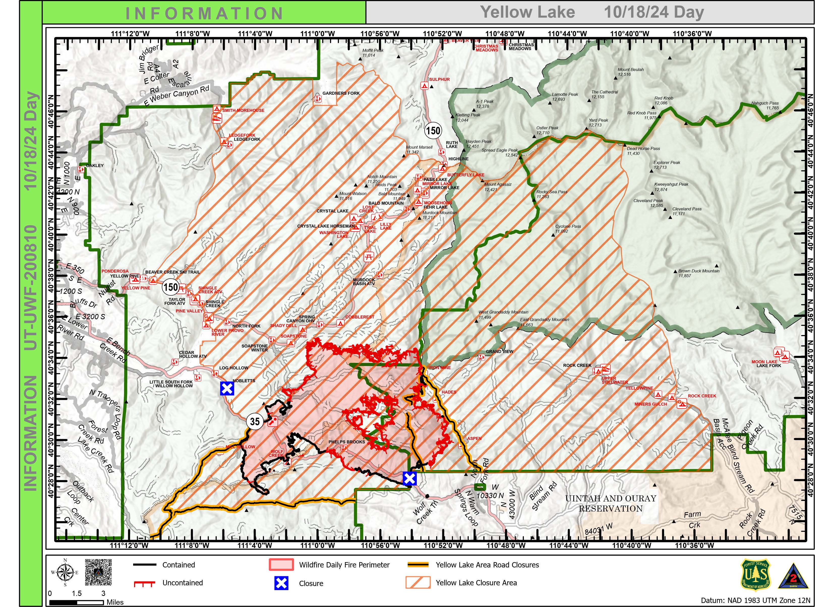
Yellow Lake Fire closure areas were reduced on the Ashley National Forest and the Uinta-Wasatch-Cache National Forest as of 6:30 a.m. Updates have been posted to the Facebook page for each Forest.
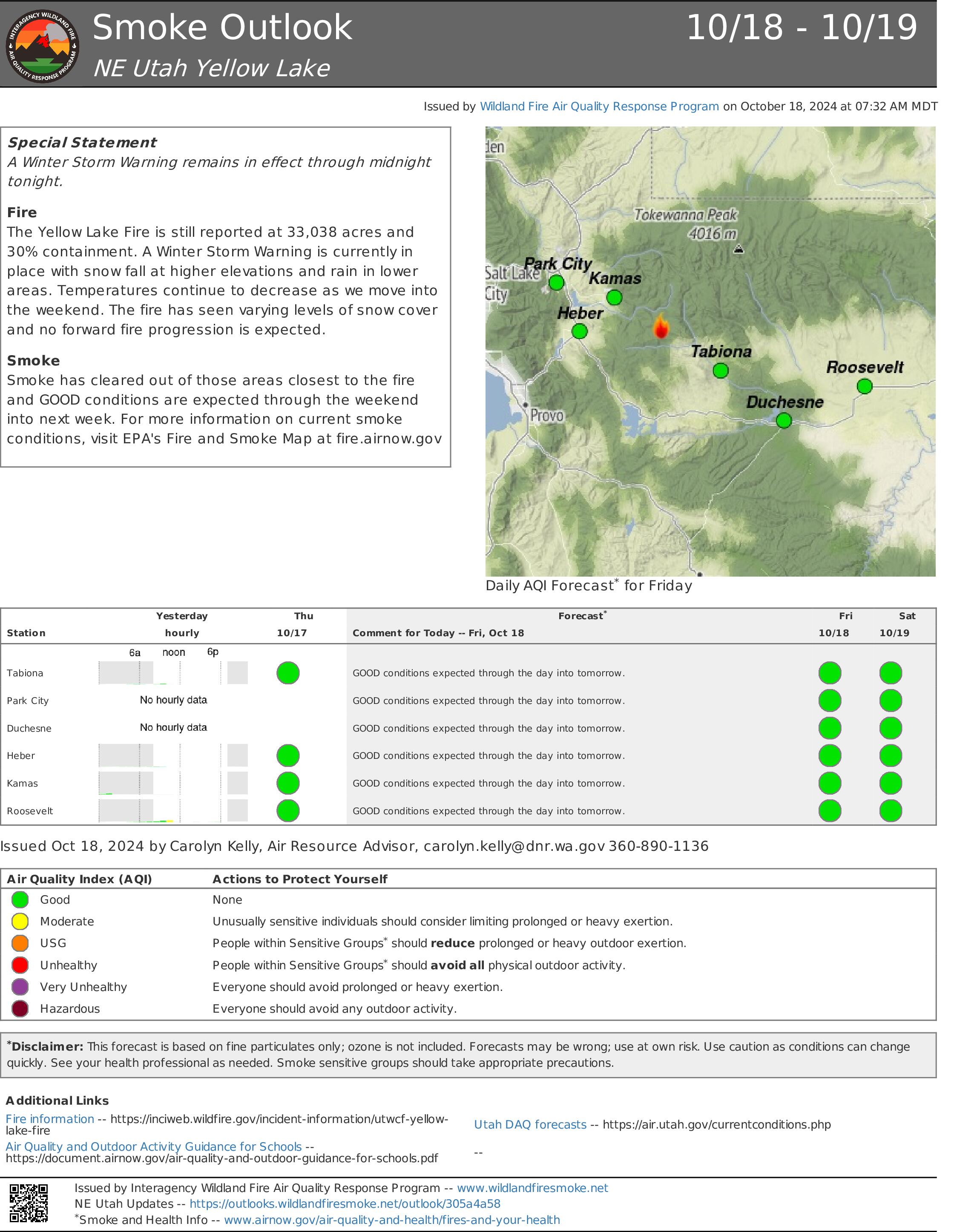
The entire fire area is receiving rain or snow this morning. About one inch of rain has fallen at lower elevations and six inches of snow has been reported at higher elevations such as Bald Mountain Pass on Mirror Lake Highway, SR150.
A winter storm warning is in effect through midnight with temperatures well below freezing.
Many fire resources are being released this afternoon due to weather and minimal fire behavior. The remaining crews are taking advantage of fireline downtime to do tool maintenance, training and extensive After-Action Reviews (AAR). In this process, crews discuss in-depth what they have been doing on the fire; what worked well; what could have been improved; how it could have been improved, and lessons learned. The AAR is a standard process in all levels of incident management.
This morning, a few firefighters are speaking to students at Duchesne Elementary School to personally thank them for their creative thank you cards.
Team transition will begin on Sunday from the California Interagency Incident Management Team 2 to the local Type 3 team comprised primarily of personnel from the Uinta-Wasatch-Cache and Ashley National Forests.
A community meeting will be held on Saturday afternoon at 4:00 p.m. in the Kamas Middle School Auditorium to discuss the transition, including fire area rehabilitation and closures.
A similar community meeting is scheduled at the Tabiona School gymnasium at 4:00 p.m. Sunday.
Forest Closures:
- Updated October 18, 2024, the Yellow Lake Fire closure area has been reduced on the Uinta-Wasatch-Cache National Forest. This Order shall remain in effect until November 25, 2024, unless rescinded.
https://www.fs.usda.gov/Internet/FSE_DOCUMENTS/fseprd1208350.pdf - Updated October 18, 2024, the Yellow Lake Fire closure area has been reduced on the Ashley National Forest. This closure will remain in place through December 31, 2024, or until rescinded.
For updated evacuation zones, please visit:
https://emergency-management-operations-wasatch.hub.arcgis.com/
https://tricountyemergencyalert.genasys.com/portal/en
https://www.fs.usda.gov/Internet/FSE_DOCUMENTS/fseprd1208878.pdf
Quick Facts Birch Fire October 18 10 18 2024
Related Incident:
Publication Type: News
The fire had rain off and on all day. Snow level is fell to 6500' at about 4:00 pm and continues to drop as the day progresses. Lower elevations have seen some snow but it hasn’t stuck. A few smokes still showing where the fire crossed Indian Creek with snow level few hundred feet upslope of the fire.
Garden and Red Rock Fires Update 10 18 2024
Related Incident:
Publication Type: News
Evacuations reduced on Garden and Red Rock Fires
Red Rock Fire
Operations: Precipitation significantly reduced fire behavior, although heat remains in heavy fuels like logs, stumps, and trees, with flames still showing in some areas. Salt Creek is currently the area of most concern as it didn’t get much rain before the snow and smoke remained visible. Due to snow over the fire areas, firefighters assessed and monitored the fire yesterday but did not actively engage. Today, access will remain limited due to snow, rain, and freezing temperatures, but crews will engage the fire where they can safely do so. They’ll continue to patrol and monitor the activity in Salt Creek and scout for additional secondary containment lines to the south. Fire managers will continue to assess needs on the Napias Creek Fire.
Garden Fire
Operations: Precipitation significantly reduced fire behavior on the Garden Fire. Yesterday, crews patrolled the fire’s edge along the Salmon River and Panther Creek corridors. The spike camp along the Salmon River Road was dismantled, and crews will now operate from the Salmon Incident Command Post. Today, crews will continue to patrol, monitor, and act if necessary and safe. Fire managers will begin assessing repair work that needs to be done on handlines.
Additional Information
Weather: Overnight low temperatures tonight should be in the 20s. Only very light precipitation is excepted overnight, limiting snowfall to under an inch. Afternoon high temperatures will rebound into the 40s. Humidity will dry out to 40 and 45% for the afternoon, when skies should clear. Wind will be light. Strong warming and drying will continue into the weekend, but another low is expected to move in Sunday night and Monday, bringing precipitation, high humidity, and cold temperatures.
Smoke: For smoke information, please go to: https://www.airnow.gov/education/what-you-can-do/, or https://outlooks.airfire.org/outlook/ded7837a
Closures: The Salmon‐Challis National Forest has implemented a separate and reduced Red Rock and Garden Fire Closure, Order Number: 04‐13‐24‐027 and Order Number 04-13-24-028, effective as of 8:00 pm, Wednesday, October 16, 2024. https://www.fs.usda.gov/alerts/scnf/alerts-notices
Safety: A Temporary Flight Restriction (TFR) is in place over the Red Rock and Garden fire areas, which includes uncrewed aircraft systems or drones. Reminder that if you fly we can’t, unauthorized drone flights pose serious risks to firefighter and public safety and the effectiveness of wildfire suppression operations.
Please stay out of the fire area. There is still active fire behavior in the fire area, including group torching and crown runs. There are multiple roads and bridges that have been destroyed or are impassable. Entry into evacuation zones that are in “Go” status is prohibited. The updated forest closure notice that encompasses both the Red Rock Fire and Garden Fire areas includes multiple road and area closures. Barricade closures will be posted at road intersections and forest boundaries.
Evacuations: For evacuation information in Lemhi County regarding both the Red Rock and Garden fires please go to: https://www.lemhicountyidaho.org/emergency-management-department.
Yellow Lake Fire Forest Closures 10 18 2024
Related Incident: Yellow Lake Fire
Publication Type: Closures
ASHLEY NATIONAL FOREST
DUCHESNE/ROOSEVELT RANGER DISTRICT
ROAD AND AREA CLOSURE
Pursuant to 16 U.S.C. § 551 and 36 C.F.R. § 261.50 (a) and (b), the following is prohibited on the National Forest System (NFS) roads in the Duchesne/Roosevelt Ranger District, Ashley National Forest, described below and shown on the attached map incorporated into this Order as Exhibit A (the “Described Area, Campgrounds, and Roads”):
1. Being in the described area and roads. 36 C.F.R. § 261.55(a) and (b).
EXEMPTIONS:
Pursuant to 36 CFR 261.50(e), the following persons are exempt from this Order:
1. Persons with Forest Service Permit No. FS‐7700‐48 (Permit for Use of Roads or Areas Restricted by Regulation or Order), specifically exempting them from this Order or a written determination by a Forest Service authorized officer that a permit is not required under 36 C.F.R. § 251.50(e)(1) or (2).
2. Any federal, state, or local officer, or member of an organized rescue or firefighting force in the performance of an official duty.
3. Federal or state administrative personnel in performance of an official duty.
ROAD AND AREA CLOSURE DESCRIBED:
1. The area described as North Fork of the Duchesne Road (FSR 144) beginning at the forest boundary, north along this road to the Mill Flat Trail (FST 081) and then north along that trail to the middle of section 3, then west to the forest boundary and then south, then west, then south and then east along the forest boundary to the North Fork of the Duchesne Road (FSR 144).
2. FSR 144 starting from the forest boundary to its terminus.
3. FSR 174 starting from the forest boundary to its terminus
4. Aspen Campground, Hades Campground, and Iron Mine Campground.
PURPOSE:
The purpose of this Order is for public health and safety due to Yellow Lake Fire. Wildfire behavior can be unpredictable and due to the close proximity of this fire it is in the publics best interest to remain out of this area.
IMPLEMENTATION:
1. This Order shall be in effect from October 18, 2024 at 0630 AM through December 31, 2024 at 12:00 am.
2. A map identifying the Described Area and Roads is attached and made part of this Order as Exhibit A.
3. Unless otherwise expressly defined in this Order, the terms used in this Order are defined by the regulations of the Secretary of Agriculture, 36 C.F.R. Chapter II, Parts 200‐299. If there are terms in this Order that are not expressly defined in the order or 36 C.F.R. Chapter II, Parts 200‐299, their meaning shall be determined by their plain language definitions.
4. A violation of the above prohibitions is punishable as a Class B misdemeanor by a fine of not more than $5,000 for individuals and $10,000 for organizations, or by imprisonment for not more than six months, or both. 16 U.S.C. § 551; 18 U.S.C. §§ 3559, 3571, and 3581.
5. For more information about this Order, contact the Duchesne/Roosevelt Ranger District located in Duchesne, Utah, telephone (435) 738‐2482 or the Ashley National Forest Supervisor’s Office located in Vernal, Utah, telephone (435) 789-1181.
6. This Order supersedes any previous Order(s) prohibiting the same, or similar acts, in/on the Described Area and Roads.
Uinta-Wasatch-Cache National Forests
Heber-Kamas Ranger District
Yellow Lake Fire Area and Road Closures
PROHIBITIONS
Pursuant to 16 U.S.C. § 551 and 36 C.F.R. § 261.50 (a) and (b), the following acts are prohibited on the National Forest System Yellow Lake Fire Area, Roads, Campgrounds, Trails, Trailheads and Parking Area/Lots in the Heber-Kamas Ranger District, Uinta-Wasatch-Cache National Forests. Described below and shown on the attached map incorporated into this Order as Exhibit A. This Order will be in effect October 18, 2024, and shall remain in effect until November 25, 2024, unless rescinded.
1. Being in or upon the Area, Campgrounds, Roads, Campgrounds, Trails, Trailheads and Parking Area/Lots as described below and shown on the attached map. This includes all pedestrian, hikers, equestrian, bicycles, and any type of motorized vehicle. [36 CFR 261.52 (e)] and [36 CFR 261.53(e)]
EXEMPTIONS
Pursuant to 36 C.F.R. § 261.50(e), the following persons are exempt from this Order:
1. Persons with Forest Service Permit specifically exempting them from this Order or a written determination by a Forest Service authorized officer that a permit is not required under 36 C.F.R. § 251.50(e)(1) or (2).
2. Any federal, state, or local officer, or member of an organized rescue or firefighting resource in the performance of an official duty.
3. Federal or state administrative personnel in performance of an official duty.
DESCRIBED
The Yellow Lake Fire area closure includes all roads, campgrounds, trails, trailhead, parking area/lots. Starting at the Pine Valley campground going east along the south side of the Provo River to Cobblerest campground then goes east to the forest boundary, south along the forest boundary across Highway 35 to the West Fork of the Duchesne River Road (Forest Service Road #050) going west along the northside of the West Fork of the Duchesne River Road (Forest Service Road #050) to the intersection with Mill Hollow Road (Forest Service Road #054) then going north along the eastside of the Mill Hollow Road (Forest Service Road #054) to Highway 35 then going northwest on the north side of Highway 35 following the forest boundary for approx. 3 miles then north along the forest boundary to Pine Valley group campground located in Township 2 South, Range 7 East, Sections 35-36, Township 3 South, Range 7 East, Sections 1-2, 11-14, 24-25, 36, Township 3 South, Range 8 East, Section 1-36,Township 3 South, Range 9 East, Section 6-7, 17-21, 27-34, Township 4 South, Range 7 East, Section 1, 11-15, 22-24, Township 4 South, Range 8 East, Section 2-10, 15-19, Township 4 South, Range 9 East, Section 4-6 all within the Salt Lake Meridian as shown on the attached map and Township 1 North, Range 10 West, Sections 1, 2, 9-30, Township 1 North, Range 11 West, Sections 21-29, 32-36 Township 1 North, Range 6 West, Sections 3-10, 15-22, 30; Township 2 North, Range 10 West, Sections 13, 24, Township 2 North, Range 9 West, Sections 19-22, 27-34 all within the Uintah Based Meridian as shown on the attached map.
PURPOSE
To Provide for public and firefighter safety during the suppression of the Yellow Lake Fire.
IMPLEMENTATION
1. This Order will be in effect when signed October 18, 2024, and shall remain in effect until November 25, 2024, unless rescinded.
2. A map identifying the road is attached and made part of this Order as Exhibit A. For a digital version of this Order and Exhibit A, go to Uinta-Wasatch-Cache National Forest - Alerts & Notices (usda.gov).
3. Unless otherwise expressly defined in this Order, the terms used in this Order are defined by the regulations of the Secretary of Agriculture, 36 C.F.R. Chapter II, Parts 200-299. If there are terms in this Order that are not expressly defined in the Order or 36 C.F.R. Chapter II, Parts 200-299, their meaning shall be determined by their plain language definitions.
4. A violation of the above prohibitions is punishable as a Class B misdemeanor by a fine of not more than $5,000 for individuals and $10,000 for organizations, or by imprisonment for not more than six months, or both. 16 U.S.C. § 551; 18 U.S.C. §§ 3559, 3571, and 3581.
5. Contact the Heber-Kamas Ranger District, Kamas office in Kamas, Utah (435) 783-4338, Heber office in Heber, Utah (435) 654-0470 and National Forest Supervisor’s Office in South Jordan, Utah (801) 999-2103, for more information about this Order.
6. This Order supersedes any previous Orders prohibiting the same or similar acts in/on the Area, Roads, Campgrounds, Trails, Trailheads and Parking Area/Lots.
Rail Ridge Daily Update 10 18 2024
Related Incident:
Publication Type: News
Rail Ridge Fire Update
Friday, October 18, 2024
Central Oregon Wildfire Information: centraloregonfire.org
Email: 2024.railridge@firenet.gov – Phone: 541-208-7111
Social Media, Evacuation and Closure Information: https://linktr.ee/RailRidgeFire
Acres: 176,383 – Containment: 89% – Detection: 09/02/24 – Cause: Lightning – Personnel: 577
Special Notes: Although the weather conditions have decreased fire activity and fire suppression operations, there is still an immense amount of rehab work to be done on the Rail Ridge Fire. Hundreds of miles of containment and contingency line was built during initial suppression efforts that need to be repaired. Fire suppression repair or rehab, is a series of immediate post-fire actions taken to repair damages and minimize potential soil erosion and impacts resulting from fire suppression activities. Northwest Team 2 is working with the local USFS, BLM and ODF offices to supply resources and personnel to implement a mutually agreed upon suppression repair plan while they are on this assignment.
Fire suppression repair work occurs anywhere the ground is disturbed during suppression operations. This could be a small two-foot-wide handline or a 20-foot dozer fireline. Some roads are damaged by heavy equipment and need to be repaired to their previous state of use. Staging areas, supply drop points, and places where firefighters install pumps can also require repair.
Fire Behavior & Weather: Weather has been partly to mostly cloudy with on and off rain and snow showers throughout the day. Minimal rainfall was recorded, but higher elevations did see snowfall of 0.5" to 1". Humidity remained above 70% across the fire with winds gusting 20-30 mph at times. Temperatures struggled to rise much above freezing. Mostly cloudy skies will quickly move east, leaving clear skies and light to calm winds today with temperatures in the 20s. High pressure in the region today and Saturday will result in clear skies and temperatures warming from below normal today to near to slightly above normal over the weekend.
Operations Yesterday: Firefighters continued work on the fuel break at FS Road 3850. They backhauled hoses and pumps that were no longer in use. Backhauling is the process of removing supplies and equipment from a fireline after a fire has been secured. Due to the rain and snow, road repair was slow going and access was a challenge.
Operations Today: Although risk of new fire starts is very low, NW Team 2 still has initial fire attack responsibilities under the Temporary Flight Restriction (TFR) over the fire area, meaning the current resources will respond to any new fires. Heavy repair work continues throughout the fire footprint, with firefighters prioritizing their work to be the most effective given the weather and ground conditions. Most of the repair work will be in the south due to muddy roads in the north. In addition to repair work, fire crews continue to prioritize fire suppression, mop-up, and patrol where necessary.
USFS & BLM Closures / Evacuation Information / Fire Restrictions for the Rail Ridge Fire area can be found at: https://linktr.ee/RailRidgeFire.
Meridian Fire Evening Update 10 17 2024
Related Incident: Meridian
Publication Type: News
Incident Commander: Jim King
Location: 40 miles south of Ennis, MT and 10 miles southwest of Lyons Bridge on HWY 287.
Start Date: 10/08/24
Cause: Undetermined
Size: 3,900 acres (infrared mapping flight on 10/16/24)
Resources on Site: 2 20-person hand crews, 6 Type 6 engines.
Total Personnel: 74
*** This will be the last formal update for the Meridian Fire; future updates will be dictated by fire activity. ***
The Meridian Fire was reported late in the day on October 8th. Fire managers from the Beaverhead-Deerlodge National Forest have identified and prioritized critical values at risk in the fire area. Firefighting efforts will focus available resources on the protection of prioritized critical values at risk that are currently nearest the fire’s edge.
There are several factors involved in making wildfire management decisions. These factors include firefighter safety, resource availability, threats to public safety and property, terrain, fire behavior, fire season outlook and modeling, and past prescribed fire units and vegetation management projects in the area. Fire managers are strategic in their approach and continually reassess conditions and alter management strategies to protect critical values.
CURRENT STATUS/PLANNED ACTIONS:
The fire received rain and a small amount of snow overnight, preventing any fire growth today. Resources spent the day securing sections of the fire along the east flank, specifically along FS 1209 (Jack Pine) and the very northern end of the fire closest to Cliff and Wade Lakes.
Fire managers coordinated with the Madison County Sheriff’s Office, who lifted the evacuation order that was issued yesterday afternoon.
Tomorrow’s plan will be situational, depending on the amount of snow received overnight. If minimal moisture is received, similar operations will occur. If conditions associated with the predicted winter storm warning materialize, then crews will shift to removing equipment from the fire area.
“Do Not Report” signs remain in place at Raynolds Pass and the junction of HWY 87 and HWY 287 by Three Dollar Bridge to minimize 911 calls impacting Madison County Dispatch. Information boards are still in place at the MT DOT Rest Area at Lyons Bridge and Cliff/Wade Lake Campground.
All barriers into the fire area have been removed. The fire is not completely extinguished, and fire behavior is expected to be smoldering and creeping for the foreseeable future. The public should be aware that smoke and small amounts of flames may be visible until the fire area is fully covered in snow.
These actions are designed to allow fire personnel to protect the identified values at risk while operating in areas that have much better access and egress to safety.
WEATHER AND FIRE BEHAVIOR:
A winter storm warning is in effect until noon on Friday and calls for 6-14” of snow above 7,000’, including the entire fire area. Overnight temperatures will bottom out in the mid-20s, with daytime high temperatures only reaching into the mid-30s.
If forecasted conditions materialize, fire behavior will be moderated significantly.
CLOSURES AND RESTRICTIONS:
There are no fire restrictions on the Beaverhead-Deerlodge National Forest or any area closures pertaining to the Meridian Fire.
ELK HUNTING INFO and the RAIL RIDGE FIRE 10 28 2024
Related Incident:
Publication Type: Announcement
ELK HUNTING INFO and the RAIL RIDGE FIRE
“Oregon’s elk are one of the most sought-after species for hunters and the second most popular game animal after deer. Rocky Mountain elk are found in eastern Oregon and Roosevelt elk are found in western Oregon, with most concentrated in the Coast, Cascade and Blue Mountain ranges.” - Oregon Department of Fish and Wildlife
Sometimes it takes a few years or more to draw certain controlled hunt elk tags and winning your controlled hunt in the spring brings about a great deal of excitement and anticipation. Unfortunately wildfires are unpredictable and often times create an unsafe camping, hunting and recreating environment. The Rail Ridge Fire burned through some renowned hunting grounds on the Ochoco and Malheur National Forests and as a result, forest closure orders are in place for firefighter and public safety. We apologize for the inconvenience and will help point you in the right direction for areas to hunt and points reimbursement. As a reminder, stay informed for closure areas are subject to change.
Hunting and Fire Danger in Oregon
Here are some of the controlled hunts impacted by the Rail Ridge and Crazy Creek fires.
Any Legal Weapon Controlled 200 Series Hunts: 1st Elk Season and 2nd Elk Season
Wildlife Management Unit 37 OCHOCO has significant closure areas from the Rail Ridge and Crazy Creek Fires. If you drew a controlled hunt tag for the following units, your hunt may be impacted by a closure:
237X Bull Elk - Dates:10/30 to 11/03
237Y Bull Elk - Dates: 11/09 to 11/17
Ochoco - Unit 37 Map
Wildlife Management Unit 46 MURDERERS CREEK also has significant closure area from the Rail Ridge Fire.
If you drew a controlled hunt page for the following units, your hunt may be impacted by a closure:
246X Bull Elk - Dates: 10/30 to 11/03
246 Anterless Elk - Dates: 11/23 to 12/01
246A West Murderers Creek - Dates: 11/09 to 11/17
Murderers Creek - Unit 46 Map
Red Rock Evacuation Downgrade 10 17 2024
Related Incident:
Publication Type: Announcement
RED ROCK UPDATE 10/17/2024 update 1400 hours
Posted on: September 4, 2024 - 8:34am
THERE HAVE BEEN CHANGES TO THE EVACUTION ZONES, THEY ARE AS FOLLOWS:
ZONE 1 – DOWNGRADED TO “SET” FROM GO
ZONE 2 – DOWNGRADED TO “SET” FROM GO
ZONE 3 – DOWNGRADED TO “SET” FROM GO
ZONE 4 – HAS BEEN RESCINDED
ZONE 5 – DOWNGRADED TO “READY” FROM GO
ZONE 6A – HAS BEEN RECINDED
ZONE 6B – HAS BEEN RECNCINDED
Zone 1: Yellowjacket drainage
Zone 2: Cobalt to Forney
Zone 3: Forney to road #252 to road #103 and back to Moyer
Zone 4: Silver Creek, Rams Creek, and Camas Creek from Hammer
Creek to White Goat Creek
Zone 5: Cobalt to Blackbird and Leesburg.
Zone 6A: Perreau Creek to Rattlesnake Drainage
Zone 6B: Rattlesnake Drainage to include all of Elk Bend and the 93 S Corridor
Garden Fire Evacuation Downgrade 10 17 2024
Related Incident:
Publication Type: Announcement
GARDEN FIRE UPDATE 10/17 1400 hours
Posted on: October 5, 2024 - 7:32pm
THERE HAVE BEEN CHANGES TO THE EVACUATION ZONES, THEY ARE AS FOLLOWS:
ZONE 1 – DOWNGRADED TO “READY” FROM GO
ZONE 2 – DOWNGRADED TO “READY” FROM GO
ZONE 3 – HAS BEEN RECINDED
Zone 1: From Cove Creek to Ebeneezer Bar, downriver along the Salmon River Road #030.
Zone 2: On Panther Creek Rd #055, a half mile south of Beaver Creek Rd #057 to the Salmon River Rd #030 confluence.
Zone 3: Panther Creek to Spring Creek to include private land up Spring Creek.
Valley County Sheriffs Office lifts evacuation notice and opens road 10 17 2024
Related Incident: Logan Fire
Publication Type: Announcement
#LoganFire - Edwardsburg and Big Creek evacuation status has been lifted and the county road is open for travel.
With the current weather conditions, please be cautious as you drive on the road and watch for rolling rocks, debris and fallen trees. #FirefightingResources are also still in the area.