
Paradise Fire update for May 29 2025 05 29 2025
Related Incident: Paradise Fire
Publication Type: News
Acres: 727 Start Date: Monday, May 26, 2025
Location: 13 miles south of Quemado, NM Personnel: 146
Containment: 12% Cause: Human-caused, under investigation
Summary: Crews worked to bring the Paradise Fire to 12% containment on Wednesday under command of the Gila Las Cruces Type 3 Incident Management Team. The Paradise Fire is burning in ponderosa pine, pinon-juniper, and grass, approximately 13 miles south of Quemado, NM on the southern flank Escondido Mountain and north of Quemado Lake. While the perimeter of the fire has only negligibly changed, more accurate mapping shows that the fire is currently 727 acres.
Today, crews will work the perimeter of the fire to extinguish hot spots and hold the fire at established hand and dozer lines and existing roads. Firefighters continue to protect values at risk, including private property/residences, Socorro Electric Powerline, range infrastructure, Quemado Lake Recreation Area, and cultural resource sites. Aviation resources remain available if needed. The team also brought in an unmanned aerial system to fly the perimeter with an infrared camera to identify remaining areas of heat. Chipping of accumulated woody material will take place along the containment line. Considering the area’s dry conditions, Paradise Fire resources are available for initial attack with the potential for lightning in the forecast.
Weather: Thursday will bring sunshine and a high near 80. An east wind of 5-10 mph is forecasted to become southwest and reach 10-15 mph in the afternoon. There’s a slight potential for thunderstorms beginning Friday.
Closures: The Quemado Lake area is closed for public use for the protection of firefighter and public safety.
Safety: A Temporary Flight Restriction (TFR) remains in effect over the fire area. Unauthorized drone use poses a serious risk to aerial firefighting operations. If you fly, we can’t.
Smoke: Smoke production was moderate, and local air quality was rated at “good” as of Wednesday evening. For real-time smoke conditions, visit: fire.airnow.gov.
Fire Restrictions: Stage 2 Fire Restrictions are in place on the Gila National Forest. For full details, visit: https://www.fs.usda.gov/r03/gila/alerts/stage-2-fire-restrictions.
For more information:
Public Information Officer: Email Maribeth.Pecotte@usda.govor 575-388-8211, 8am - 8pm
Incident Information: https://inciweb.wildfire.gov/incident-information/nmgnf-paradise-fire
Facebook: www.facebook.com/GilaNForest
Jacobson Fire Update 05 28 2025
Related Incident: Jacobson Fire
Publication Type: Announcement
Acres: 8*
Containment: 44%
Personnel: 198
Thanks to the continued efforts of our firefighters, the Jacobson Fire reached 44% containment today. The Southeast Zone IMT will reduce resources as fire activity diminishes.
This morning, helicopters flew in blivets (portable water containers) for ground crews and helped haul supplies off the mountain. Ground crews continued to address heat within the fire perimeter.
Tonight, night crews will continue to monitor the fire and ensure that the fire remains within control features. Drone pilots will fly infrared flights tonight and early tomorrow to identify hot spots in steep and inaccessible terrain.
If you decide to drive up Mount Graham on Highway 366, please drive slowly and with caution. Even though some resources are being demobilized from this incident, there continues to be a high amount of fire traffic, both in vehicles and on foot. Please protect our firefighters by driving slowly, especially around corners.
The public should continue to avoid Ladybug Trail #329 and Turkey Flat Trail #330, as firefighters continue to work in the area.
*Mild increase in reported acreage due to more accurate mapping.
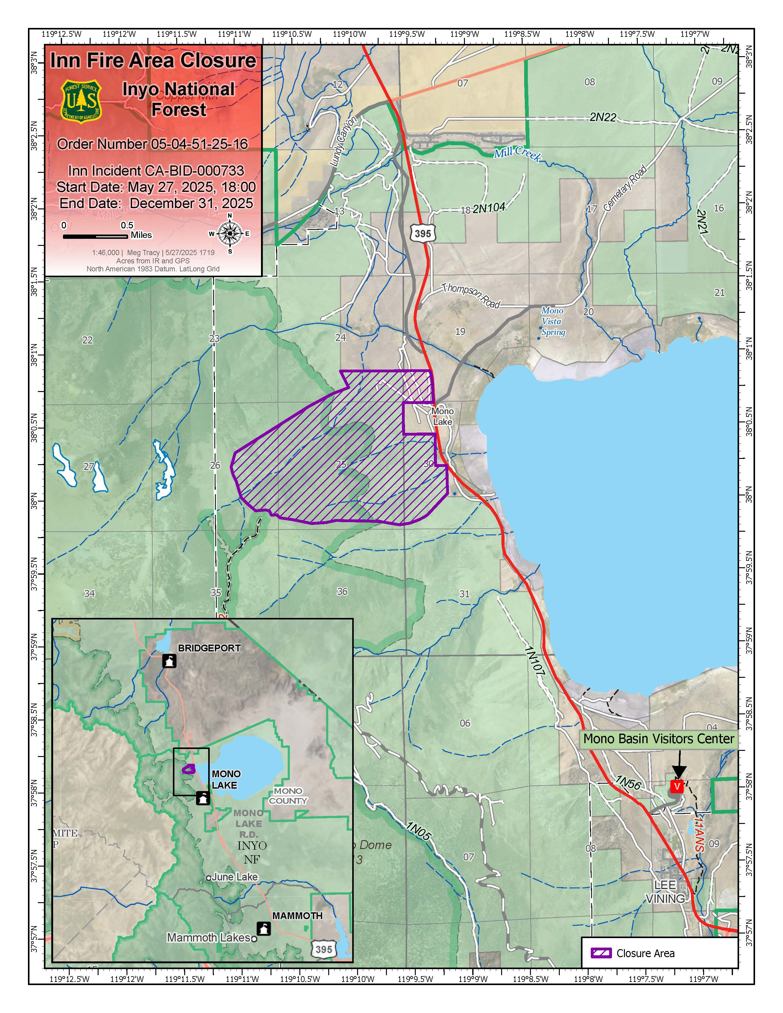
Area Closure In Effect May 28 2025 05 28 2025
Related Incident: Inn Fire 2025
Publication Type: Closures
Area Closure Order implemented for the Inn Fire
Bishop, Calif., May 28, 2025— Inyo National Forest has implemented a Forest Order prohibiting entrance into the Inn Fire Area Closure to protect public health and safety from environmental hazards, wildfire, and wildfire suppression operations.
For the official order and corresponding map, visit: www.fs.usda.gov/r05/inyo/alerts/inn-fire-closure-order
“Firefighters are engaged in fire suppression and rehabilitation efforts on and in the vicinity of the Inn Fire, and this closure will help ensure both they and the public are kept safe until the hazards associated with this fire are mitigated,” said Mono Lake District Ranger Stephanie Heller.
There are multiple hazards associated with the burn within this area including rockfall, loose soils, and burning stumps. There are also four Nation Forest System Roads that are impacted by the fire that need to be assessed for hazards.
The Inn in fire started in the afternoon of May 22, 2025 and quickly grew rapidly involving extremely steep slopes on Nation Forest System Lands. Closure of the area shown on the attached map is necessary to help ensure that no one is injured within or near the fire perimeter.
For updated information on the Inn Fire, visit: https://inciweb.wildfire.gov/incident-information/cainf-inn-fire-2025
 05272025.pdf.jpg?VersionId=ZDyJM7CkyMARToKmBcNmB6glb_rpNQve)
Paradise Fire Press Release Wednesday May 28 2025 Gila Las Cruces Type 3 Incident Management Team assumes command 05 28 2025
Related Incident: Paradise Fire
Publication Type: News
Acres: 578
Start Date: Monday, May 26, 2025
Location: 13 miles south of Quemado, NM
Personnel: 115
Containment: 0%
Cause: Human-caused, under investigation
Summary: The Gila Las Cruces Type 3 Incident Management Team assumed command of the Paradise Fire yesterday evening. The Paradise Fire is burning in ponderosa pine, pinon-juniper, and grass, approximately 13 miles south of Quemado, NM on the southern flank Escondido Mountain and north of Quemado Lake. It is currently 578 acres in size based on infrared flyover last night.
Conditions are extremely dry promoting active fire growth during daytime hours. Crews have observed active fire behavior with fire making runs, and torching in individual trees and groups of trees. Fire crossed a dozer line on the north side of the fire perimeter yesterday and was moving south toward Quemado Lake. Fire personnel were able to stop forward progress with help from aviation resources.
Today, crews will work to hold the fire at established hand and dozer lines and roads, and protect values at risk, including private property/residences, Socorro Electric Powerline, range infrastructure, Quemado Lake Recreation Area, and cultural resource sites. Resources are available for initial attack with the potential for lightning in the forecast.
Weather: Sunny and warm, in the upper 70s. Light southerly winds becoming southwest 5 to 15 miles per hour. Potential thunderstorms within the next few days, bringing a possibility of lightning and gusty outflow winds in the vicinity of storms.
Closures: The Quemado Lake area is closed for public use for the protection of firefighter and public safety.
Safety: A Temporary Flight Restriction (TFR) remains in effect over the fire area. Unauthorized drone use poses a serious risk to aerial firefighting operations. If you fly, we can’t.
Smoke: Daytime smoke production has been moderate, with a smoke column is visible from Quemado, Quemado Lake Estates, New Mexico Highways 12 and 32, and US Highway 60. For real-time smoke conditions, visit: fire.airnow.gov.
Fire Restrictions: Stage 2 Fire Restrictions are in place on the Gila National Forest. For full details, visit: www.fs.usda.gov/r03/gila/alerts.
For more information:
Public Information Officer: Email Maribeth.Pecotte@usda.gov or 575-388-8211, 8am - 8pm
Incident Information: https://inciweb.wildfire.gov/incident-information/nmgnf-paradise-fire
Facebook: www.facebook.com/GilaNForest
Daily Update for Jenkins Creek and Horse River May 28 2025 05 28 2025
Related Incident: Jenkins Creek FireHorse River Fire
Publication Type: News
Jenkins Creek & Horse River Fires Update
May 28, 2025
Fire Information:
610-574-1130, 9 a.m.–8 p.m.
LinkTree: www.linktr.ee/2025.HorseRiver
Email: 2025.JenkinsCreek@firenet.gov
As of 7 a.m. today, the National Incident Management Organization (NIMO) team assumed command of both the Jenkins Creek and Horse River Fires. NIMO teams specialize in managing complex, long-duration incidents, focusing on strategic coordination. The Jenkins Creek Fire, which began on May 12, is being managed as a full suppression fire, with efforts now focused on suppression repair. Ignited by lightning on May 22, the Horse River Fire continues to smolder with limited spread in a remote part of the Boundary Waters Canoe Area Wilderness (BWCAW), near the U.S.–Canada border. The fire is managed for full suppression; however, poor access and rugged terrain require aerial support and canoe travel for suppression.
Jenkins Creek Fire
Size: 16,089 acres Containment: 84% Personnel: 246
Recent Unstaffed Aerial System (UAS/drone) flights detected multiple heat sources in the south and one in the north of the Jenkins Creek Fire. Firefighters quickly conducted mop-up operations to extinguish remaining heat and prevent re-ignition, especially near the perimeter and values at risk. Resources from the nearby Camp House Fire have been reassigned to support suppression efforts. Crews and equipment remain strategically positioned, focusing on areas with higher fire potential. On the northeast edge, where containment is incomplete, crews continue patrolling for heat, spot fires, and flare-ups. Chipping along 137 Road and Skibo Road is ongoing to reduce fire risk, control erosion, and aid recovery. These operations should finish by week’s end. Road grading has started and is expected to continue for at least another week.
Horse River Fire
Size: 20-25 acres Containment: 0% Personnel: 2
The Horse River Fire in the BWCAW remains active, visually estimated to be 20–25 acres with 0% containment. Thick duff and dead balsam fir trees are fueling the fire and complicating suppression efforts. The eight firefighters who rappelled in a few days ago were able to assess conditions and will be safely extracted today, providing vital intelligence for fire managers. Two wilderness rangers are also in the area, informing backcountry visitors and promoting safety. Fire crews continue aerial monitoring to identify hotspots. To aid suppression, two Wildland Fire Modules—small, specialized crews for remote areas—have been ordered. These crews of 7–10 firefighters work independently in remote areas, using hand tools and helicopters to contain fires, construct firelines, and safeguard resources and public safety.
Fire Weather & Behavior: Recent showers brought some moisture, with Jenkins Creek getting more than Horse River, which only had a light sprinkle. While helpful, the rain was too light over Horse River to affect deep fuels like duff or dead fir. There's a 20% chance of wetting rain today, but it’s unlikely to suppress fire activity, especially with possible afternoon thunderstorms that could cause erratic winds and new ignitions. High temperatures in the low 70s support moderate fire behavior, but warming and gusty winds later this week may dry vegetation and increase fire activity.
Air Operations: Aircraft is available and may be brought in to help support both fires, if needed. UAS (drones) flights are still being conducted over the Jenkins Creek Fire to detect any heat sources that remain within the perimeter of the fire. A temporary flight restriction remains in effect over the Jenkins Creek fire area.
Reminder: Flying drones over or near wildfires is strictly prohibited. If a drone is spotted, all aerial firefighting operations must be grounded immediately, which can delay critical suppression efforts and put lives at risk. Drones are also illegal in federally designated wilderness areas, including the BWCAW. Help protect firefighters and the public—keep your drones out of wildfire zones.
Reminder: Flying drones over or near wildfires is strictly prohibited. If a drone is spotted, all aerial firefighting operations must be grounded immediately, which can delay critical suppression efforts and put lives at risk. Drones are also illegal in federally designated wilderness areas, including the BWCAW. Help protect firefighters and the public—keep your drones out of wildfire zones
Horse River Fire Closure Order 05 28 2025
Related Incident: Horse River Fire
Publication Type: Closures
Forest Service News Release
Joy VanDrie, Public Affairs Staff Officer
231-878-0998, joy.vandrie@usda.gov
https://www.fs.usda.gov/r09/superior
Superior National Forest Issues Closure Order for Horse River Fire
The Horse River Fire Emergency Closure Order 09-09-25-06 in the BWCAW is effective May 27, 12:01pm CT.
Duluth, MN. May 28, 2025 — The Superior National Forest (SNF) Forest Supervisor Tom Hall has issued Emergency Forest Order Closure 09-09-25-06 effective May 27, 2025, at 12:01pm. due to wildfire activity in the BWCAW Horse Lake area, on the Kawishiwi Ranger District. This closure closes the area to visitors, currently only affecting the winter route (dog sled portage) between Jackfish Bay and Lower Basswood Falls and the immediate fire area of Horse River Fire. Paddlers in the area are advised to stay away from the area for their own safety. Please check the Horse River Fire Facts on https://inciweb.wildfire.gov/incident-information/mnsuf-horse-river-fire
This closure may be modified or extended as conditions allow; check the Forest Alert for all wildfire and other emergency or closure related details: https://www.fs.usda.gov/r09/superior/alerts.
The Forest Service has notified Recreation.gov reservation holders, concessionaires, and is encouraging those with reservations in the area to seek an alternate area of the Superior National Forest for similar experiences. The emergency closure is necessary for the safety of our visitors, area residents and our firefighters.
Beyond the closure for the current wildfires, the remaining Superior National Forest is open to the public and no other restrictions apply.
###
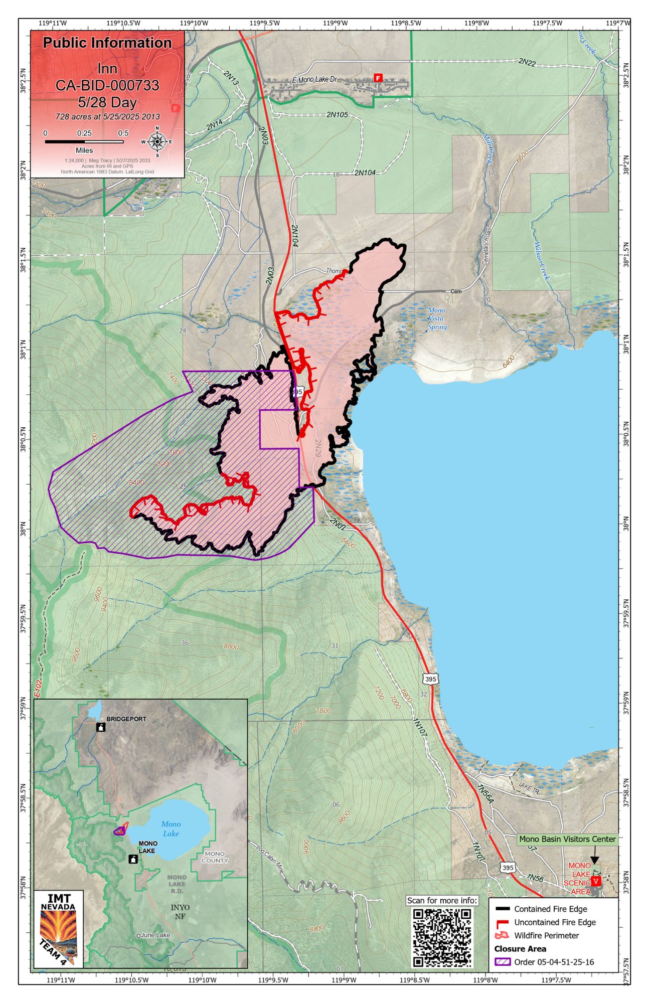
Inn Fire Update May 28 2025 05 28 2025
Related Incident: Inn Fire 2025
Publication Type: News
Inn Fire Update
Wednesday, May 28. 2025
Contact Fire Information: 760-350-2737
E-mail: 2025.inn@firenet.gov
Facebook: facebook.com/inyonf/
InciWeb: inciweb.wildfire.gov/incident-information/cainf-inn-fire-2025
Start Date: 5/22/2025
Acreage: 728 acres
Containment: 70%
Personnel: 474
Inn Fire Update – May 28, 2025
Firefighters continue to make progress on the Inn Fire, which is now 70% contained as of last night. Crews are focused on mop-up operations, working more than 100 feet in from the fire’s edge to secure the perimeter. Mop-up involves using water or hand tools to stir and cool any remaining heat, ensuring that hidden embers or hotspots are fully extinguished.
Suppression repair efforts have also begun in some areas of the fire. This work includes using equipment and guidance from resource advisors to reduce the impacts of fireline construction and restore the landscape as much as possible. These repairs help prevent erosion and support ecological recovery. Suppression repair can also involve back haul of firefighting equipment. During the Initial Attack phase approximately 3 miles of hose was deployed, as well as various pumps, and water tanks.
Firefighters remain actively engaged in increasing the containment percentage, continuing to mop-up, patrol, and secure the fireline, while suppression repair will expand to additional areas as conditions allows
Cooler conditions prevail over the fire area in the early morning, however temperatures are expected to increase to 80 degrees this afternoon with an increased chance of showers and thunderstorms.
Please continue to use caution in and around the fire area and thank you for your continued support of the crews working hard on the fireline.
As of May 25, Highway 395 has reopened. Drivers are advised to use caution and remain alert for fire personnel and equipment working in the area.
Please continue to monitor updates from CalTrans District 9 and the Mono County Sheriff’s Office for the latest information on road status and evacuation guidance.
![]() For more information, visit the incident website:
For more information, visit the incident website:
https://inciweb.wildfire.gov/incident-information/cainf-inn-fire-2025
Jacobson Fire Morning Update 05 28 2025
Related Incident: Jacobson Fire
Publication Type: Announcement
Despite dry conditions, there was no growth on the Jacobson Fire last night. Night crews spent their shift running patrols around the fire area, monitoring fire activity. The infrared flight successfully mapped hot areas within the fire perimeter, and crews today will focus their attention on those remaining hot areas.
Helicopters will assist ground crews by bringing in “blivets”, which are large, portable water containers used to store and deliver water to remote areas. Because the terrain on this fire is so steep, any water dropped from the air could cause burning debris to break free of the canopy or roll down hill and ignite a spot fire outside of the fire perimeter. Blivets are often used in situations like the Jacobson Fire, where there is no easy access to a water source and crews are working on difficult terrain. Ground crews will hike into the area and attach hoses to the delivered blivets to extinguish any heat along the fire perimeter.
Yesterday, the structure group put in fireline around the cabins at Turkey Flat and prepared to respond to any hazards to the recreation residences. The structure group will continue mapping the values at risk today to remain prepared for any incidents.
Conditions are predicted to remain dry, with zero percent chance of precipitation. Winds are expected to be 4-14mph, with some gusts up to 20mph.
Cody Fire Daily Update for May 28 2025 05 28 2025
Related Incident: Cody Fire
Publication Type: News
Crews secure and patrol containment lines with extremely dry, hot conditions forecasted
May 28, 2025
Acres: 1,223
Start Date: May 21, 2025
Location: Oracle, AZ
Cause: Under Investigation
Personnel: 400
Fuels: Grass, brush, and timber
Containment: 90%
Highlights: The Cody Fire is now at 90% containment. Suppression repair efforts are nearing completion, and a transfer of command to the local Type 4 Fire Team is planned for Thursday, May 29, 2025, at 6:00 pm.
Fire Activity: Yesterday, crews patrolled the fire perimeter, reinforced containment lines and advanced suppression repair efforts. Today, similar operations will continue. Crews will patrol the fire area and repair resources effected by suppression efforts (i.e., fences and bulldozer lines) to mitigate environmental damage and restore the landscape.
Incident staff continue structure assessments to the northwest of the fire area and utility providers are working on essential repairs to powerlines in and around impacted communities.
Evacuations: Per the Pinal County Sheriff’s Office evacuation zone 18 has been downgraded to normal daily activities with no further restrictions.
Weather: The fire area will experience temperatures in the low 90s, single digit humidity and winds from 8-13mph with gusts up to 25mph.
Safety: Incident responders and utility crew traffic continue across the fire area. As a reminder, the public is encouraged to avoid fire-affected areas to allow incident personnel and utility crews to complete their work safely and efficiently.
Road Closures: The following roads are closed - Cody Loop/Sam Clemens; Cody Loop/Durant Rd. More information is available at https://az511.gov.
Fire Restrictions and Closures: Closures are in effect and Stage 2 Fire Restrictions are issued for the Coronado National Forest, which includes recreational shooting (https://www.fs.usda.gov/r03/coronado/alerts). Stage 2 restrictions are also in effect on State Trust Lands in southern/southeastern Arizona (wildlandfire.az.gov).
More Information:
Fire Information Phone: (520) 527-2940 (8 a.m. – 8 p.m.)
Media Information Phone: (520) 527-2934 (8 a.m. – 8 p.m.)
InciWeb: https://inciweb.wildfire.gov/azcnf-cody-fire
Facebook: https://www.facebook.com/CoronadoNF/
Email: 2025.cody@firenet.gov
Jacobson Fire Update 05 27 2025
Related Incident: Jacobson Fire
Publication Type: Announcement
The Jacobson Fire held within its perimeter throughout the day today. Fixed wing retardant and helicopter water drops in combination with ground crews slowed fire progression today. Challenges that the crews are facing include steep slopes with many rolling rock hazards.
Night resources will remain on scene in case of burning debris rolling downhill outside of the fire perimeter. Structure protection resources will be in place assessing the Turkey Flat recreation residences in the low-probability event that the fire continues to grow. Aircraft will fly over the fire tonight to gather infrared data to help inform responders of any remaining hot spots on the fire. A drone is on order to assist tomorrow in collection of infrared data to locate hot spots in some of the inaccessible terrain within the fire perimeter.