
Settings - change map background and toggle additional layers
Filter - control incident types displayed on map.
Zoom to your location
Reset map zoom and position
Could not determine your location.
Show Legend
 Wildfire
 Prescribed Fire
 Burned Area
Response
Burned Area
Response Other
Other
Paradise Fire
Unit Information
Incident Contacts
Settings - change map background and toggle additional layers
Filter - control incident types displayed on map.
Zoom to your location
Reset map zoom and position
Could not determine your location.
Show Legend
- Wildfire
- Prescribed Fire
- Burned Area
Response
- Other
Jacobson Fire
Unit Information
Incident Contacts
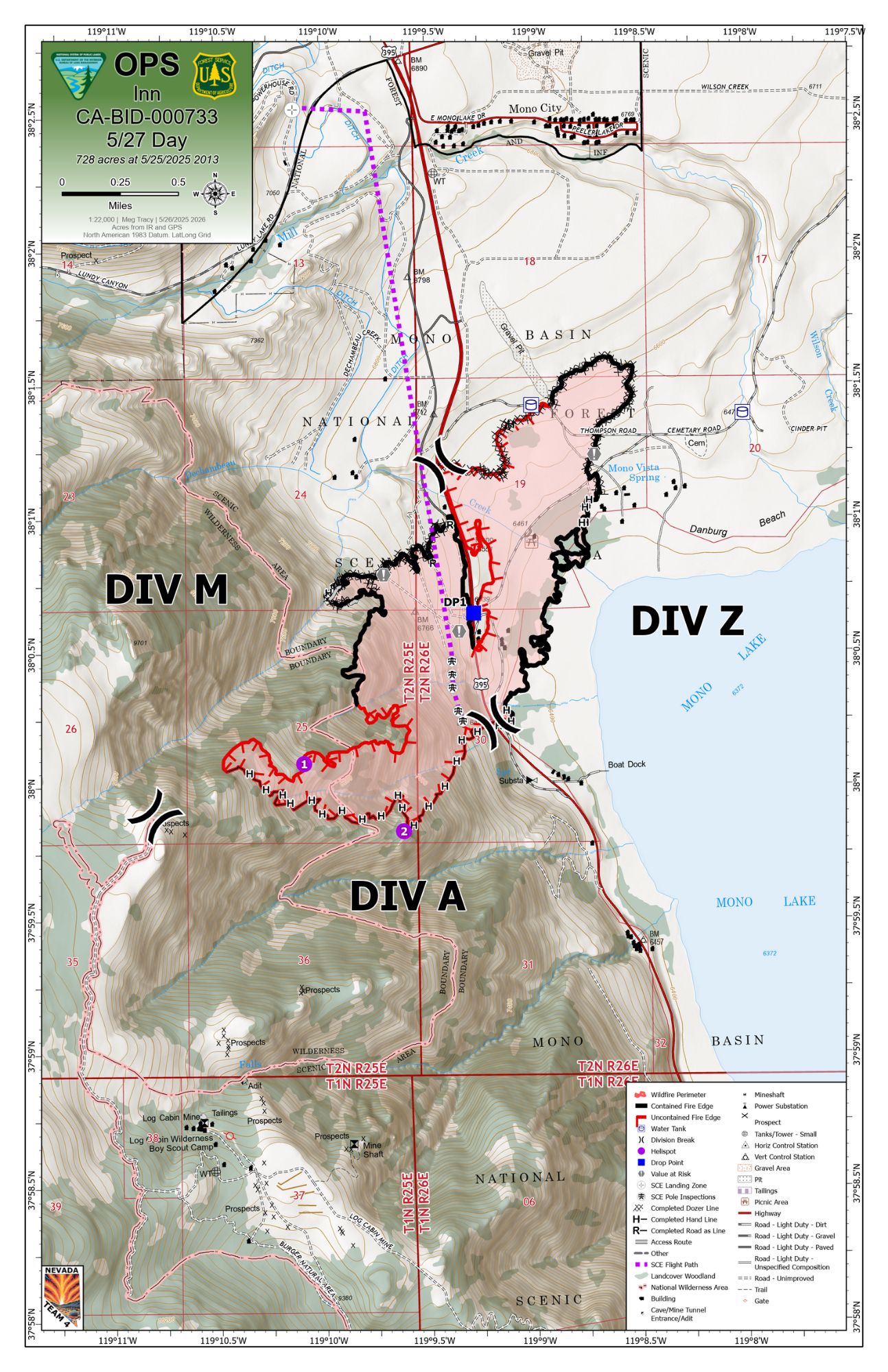
Inn Fire Update May 27 2025 05 27 2025
Related Incident: Inn Fire 2025
Publication Type: News
Inn Fire Update
Tuesday, May 27, 2025
Contact Fire Information: 760-350-2737
E-mail: 2025.inn@firenet.gov
Facebook: facebook.com/inyonf/
InciWeb: inciweb.wildfire.gov/incident-information/cainf-inn-fire-2025
Start Date: 05/22/2025
Cause: Under Investigation
Size: 725 Acres
Containment: 54%
Helicopters: 4
Heavy Equipment: 2
Engines:27
Crews:10
Personnel: 494
Inn Fire Update – May 27, 2025
Firefighters continue to increase containment on the Inn Fire, which is now 54% contained as of last night. Containment has been secured along the entire east side of Highway 395 and parts of the west side, where firefighters have completed dozer and handlines. In the remaining uncontained areas, crews are working in extremely steep and rugged terrain to establish a secure perimeter.
Crews are also focused on mop-up operations, which involve working at least 100 feet inward from the fire's edge. During mop-up, firefighters use water and hand tools to stir the ground and cool any remaining heat. This process ensures that hidden embers or hotspots are fully extinguished, reducing the risk of flare-ups and helping to strengthen containment lines.
To further reduce risk in an extremely dry field on the northeast side of the fire, a sprinkler system is being utilized to keep the area moist and help prevent any potential flare-ups.
In some parts of the fire, crews have also begun backhauling equipment—removing hose and other fireline tools that are no longer needed—as containment efforts increase.
Firefighters remain actively engaged in increasing containment, continuing to mop-up, patrol, and secure the fireline.
As of May 25, Highway 395 has reopened. Drivers are advised to use caution and remain alert for fire personnel and equipment working in the area.
Please continue to monitor updates from CalTrans District 9 and the Mono County Sheriff’s Office for the latest information on road status and evacuation guidance. Thank you for your continued support of the hardworking crews on the fireline.
![]() For more information, visit the incident website:
For more information, visit the incident website:
https://inciweb.wildfire.gov/incident-information/cainf-inn-fire-2025
Cody Fire Daily Update for May 27 2025 05 27 2025
Related Incident: Cody Fire
Publication Type: News
Evacuation status reduced for the Cody Fire
Containment increases as crews mop-up and address suppression repair needs
May 27, 2025
Acres: 1,223
Start Date: May 21, 2025
Location: Oracle, AZ
Cause: Under Investigation
Personnel: 573
Fuels: Grass, brush, and timber
Containment: 90%
Highlights: Thanks to the tireless efforts and strong collaboration among incident crews and partner agencies, the Cody Fire is now 90% contained. Suppression repair efforts are underway to restore areas impacted by firefighting operations and prepare the landscape for long-term recovery.
As residents begin returning to their homes, we ask you to remain alert. Please travel cautiously as firefighters and incident crews are still actively engaged in the area. Additionally, while the fire threat has diminished, hot, dry conditions continue, and awareness is still essential. Dust devils are picking up ash from the ground and look like a smoke column. This may continue until monsoon rains arrive.
Fire Activity: Yesterday, crews were actively engaged in patrolling the fire perimeter, reinforcing containment lines and mopping up remaining heat sources. Today, personnel remain strategically positioned across the fire area, continuing to secure fireline around the perimeter and support ongoing mop-up operations.
Structure impacts and suppression repair assessments are nearly complete and utility providers are conducting essential repairs to powerlines in and around communities.
Evacuations: Updated evacuation orders are in place to ensure public safety. Effective Monday evening, Zone 18 in the Oracle area is in SET status. Zone 17 has been downgraded with no further restrictions.
Weather: The region will experience a steady increase in temperature today and through the week, reaching upper 80s-low 90s, with single-digit humidity levels.
Safety: Incident responders and utility crew traffic continue across the fire area. For public and firefighter safety, please avoid the area to allow incident personnel to work to respond to firefighting and suppression repair needs.
Road Closures: The following roads are closed - Cody Loop and Wildcat Trail; Cody Loop and MT Lemmon Hwy (East End). More information is available at https://az511.gov.
Fire Restrictions and Closures: Closures are in effect and Stage 2 Fire Restrictions are issued for the Coronado National Forest, which includes recreational shooting (https://www.fs.usda.gov/r03/coronado/alerts). Stage 2 restrictions are also in effect on State Trust Lands in southern/southeastern Arizona (wildlandfire.az.gov).
The fire area is under Temporary Flight Restrictions (TFRs); if you fly a drone near the fire area, our aircraft will be grounded.
More Information:
Fire Information Phone: (520) 527-2940 (8 a.m. – 8 p.m.)
Media Information Phone: (520) 527-2934 (8 a.m. – 8 p.m.)
InciWeb: https://inciweb.wildfire.gov/azcnf-cody-fire
Facebook: https://www.facebook.com/CoronadoNF/
Email: 2025.cody@firenet.gov
May 27 Daily Update for Jenkins Creek and Camp House Fires 05 27 2025
Related Incident: Jenkins Creek FireCamp House Fire
Publication Type: News
CAMP HOUSE AND JENKINS CREEK FIRES UPDATE:
Tuesday, May 27, 2025
CAMP HOUSE FIRE
Size: 12,071 acres
Location: Brimson, MN
Personnel: 184
Start Date: 05/11/2025 Containment: 90%
Cause: Under investigation
Suppression repair continues across the fire area, with a concentrated effort around Camp House. Priority is being given to locations where repair activities can help protect ecologically significant wild rice lakes. Wild rice is highly sensitive to changes in water levels and water quality, thriving only under specific chemical and ecological conditions. As an indicator species for aquatic health and a critical food source for migrating waterfowl, protecting these habitats is a key objective in the repair process. Crews are actively recontouring dozer lines by redistributing mounded soil and returning displaced vegetation to disturbed areas. These actions promote faster recovery of native plant communities and help prevent the spread of invasive species. Native vegetation is more effective at stabilizing soil, reducing the risk of sediment runoff into nearby lakes, and helping to preserve water quality for sensitive ecosystems like wild rice habitats. Tomorrow, the Camp House Fire will be turned back over to the Minnesota Department of Natural Resources for continued management.
JENKINS CREEK FIRE
Size: 16,089 acres
Location: T57N R13W Section 3
Personnel: 249
Start Date: 05/12/2025
Containment: 84%
Cause: Human-caused
Crews continue making progress on the Jenkins Creek Fire, focusing on mop-up and patrol, hazard tree removal, log hauling, and road repair. Work is advancing from the southern perimeter and moving westward around the fire’s edge. Fire suppression efforts and the use of heavy equipment have impacted many forest roads, contributing to erosion, drainage issues, and safety concerns. Repairs are essential for restoring safe access, reducing hazards, and supporting long-term recovery and future forest use. The National Incident Management Organization (NIMO) team has begun arriving and is coordinating with the Eastern Area Incident Management Team to ensure a smooth transition before assuming command of both the Jenkins Creek and Horse River Fires at 6 a.m. on Wednesday. NIMO will assume command of both the Jenkins Creek and Horse River Fires at 7 a.m. on Wednesday. Horse Creek is burning within the Boundary Waters Canoe Area Wilderness, northeast of the Jenkins Creek Fire. With added capacity and experience in complex terrain, NIMO is well-positioned to manage both fires.
OTHER INFO:
Evacuation, Road Closure, and Homeowner Access Information
St. Louis County: https://tinyurl.com/LakeCoMnEvacuationMap: All evacuation zones (Ready, Set, Go) for the Brimson Complex Fire are no longer active, and Bundle Lake Road has reopened. Skibo Road and FR-113 remain closed due to ongoing wood clearing and chipping. The Superior National Forest closure order remains in place to ensure public safety and protect resources.
Lake County: https://tinyurl.com/StLouisCoSituationMap. The Lake County Sheriff’s office announced that all evacuations have been lifted in that county.
National Weather Service Forecast: Today’s fire weather brings increasing clouds, with scattered showers expected after noon. Humidity will be slightly higher than yesterday. Light southeast winds are forecast, with a 20% chance of wetting rain. Visit www.weather.gov/dlh for updates.
Laurentian Ranger District closures: Emergency Forest Order 09-09-25-05 restricts access to specific campsites and recreation areas. See Exhibit A (closure list) and Exhibit B (map) for details. The order may change as conditions evolve. Visit the Superior National Forest website under Alerts or view the map at tinyurl.com/BrimsonComplexClosureOrderMap.
Current Burning Restrictions: https://www.dnr.state.mn.us/.../firerating_restrictions.html
Public Reminder: “Stay Vigilant: Fire Season Is Not Over Yet”
As the Camp Creek and Jenkins Creek fires wind down, we must not let our guard down. Though nearing full containment, shifting fire weather—warmer temperatures, lower humidity, and increasing winds—signals rising risk, not rest. Fine fuels are drying quickly, and receptive landscapes remain vulnerable. Stay ready. Stay aware. Stay safe.
Questions? Email: 2025.camphouse@firenet.gov
Greer Fire Fully Contained Command Transitions to Local Type 4 Team 05 26 2025
Related Incident: Greer Fire
Publication Type: News
Smoke May Still Be Visible, Public Asked to Use Caution in the Area
GREER, Ariz. — As of this evening, command of the Greer Fire has transitioned from a Type 3 incident management team to a local Type 4 organization. This transition marks a significant step in the fire response, as crews continue to monitor the area and address any remaining interior heat.
Thanks to the dedicated efforts of firefighters, fire managers were confident in declaring the fire 100% contained following today’s operational shift. However, residents and visitors are advised that smoke may still be visible in the area. Isolated interior pockets of fuel continue to burn, and firefighters remain on the scene conducting patrols.
Motorists traveling through the fire area are urged to drive cautiously, as crews and equipment may still be present on local roads.
In addition, the Benny Knoll green waste pit has now reopened to the public. The local unit reminds users to exercise caution while accessing the site.
The cause of the Greer Fire remains under investigation. A final report will be released once the investigation is complete.
For additional information or questions about the fire, please contact the Springerville Supervisor’s Office and ask to speak with the Public Affairs Officer.
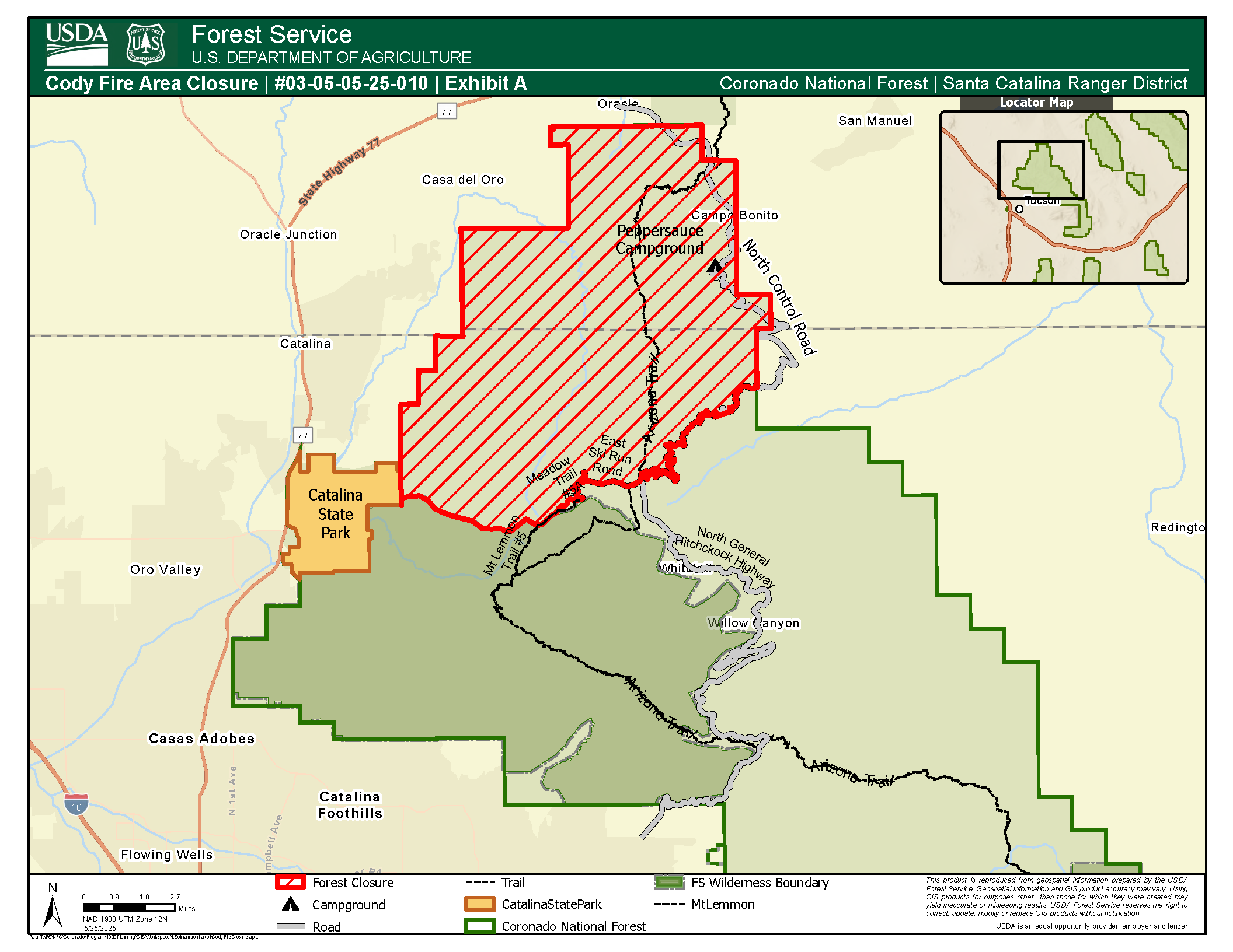
Cody Fire Closure Update as of May 26 2025 05 26 2025
Related Incident: Cody Fire
Publication Type: Closures
Order Number: #03-05-05-25-010
U.S. Department of Agriculture, U.S. Forest Service
Coronado National Forest
Santa Catalina Ranger District
AREA CLOSURE, OCCUPANCY AND USE RESTRICTIONS
PROHIBITIONS
Pursuant to 16 U.S.C. § 551 and 36 C.F.R. § 261.50(a), the following is prohibited on the National Forest System (NFS) lands in the Santa Catalina Ranger District, Coronado National Forest, described below and shown on the attached map incorporated into this Order as Exhibit A (the “Described Area”):
1. Entering, going into, or being in or upon the Described Areas 36 C.F.R. § 261.53(e);
EXEMPTIONS
Pursuant to 36 C.F.R. § 261.50(e), the following persons are exempt from this Order:
1. Persons with Forest Service Permit No. FS-7700-48 (Permit for Use of Roads, Trails, or Areas Restricted by Regulation or Order), specifically exempting them from this Order or a written determination by a Forest Service authorized officer that a permit is not required under 36 C.F.R. § 251.50(e)(1) or (2).
2. Any Federal, State, or Local Officer, or member of an organized rescue or firefighting resource in the performance of an official duty.
3. Persons using any NFS road or the following NFS trails: Mount Lemmon (#5) and Meadow (#5A).
DESCRIBED AREA
As depicted in the map at Exhibit A, the Described Area consists of all National Forest lands within the Santa Catalina Ranger District starting at 32.48871, -110.69562 where the Control Road intersects the Forest Boundary within Township 11 South, Range 16 East, Section 10.
Following the Forest Boundary north to Township 11 South, Range 16 East, Section 2, then east and north within Township 10 South, Range 16 East, Section 34, then west to Township 10 South, Range 16 East, Section 28, then north past Peppersauce Campground to Township 10 South, Range 16 East, Section 4, then west to Township 10 South, Range 16 East, Section 5, the north to Township 10 South, Range 16 East, Section 5, then west to Township 10 South, Range 15 East, Section 3, then south to Township 10 South, Range 15 East, Section 3, then east to Township 10 South, Range 15 east, Section 2, then south to Township 10 South, Range 15 East, Section 14, then West to Township 10 South, Range 15 East, Section 19, then south to Township 11 South, Range 15 East, Section 5, then west to Township 11 South, Range 15 East, Section 6, then South to Township 11 South, Range 15 East, Section 7, then west to Township 11 South, Range 14 East, Section 12, then west to Township 11 South, Range 14 East, Section 12, then south to Township 11 South, Range 14 East, Section 12, then west to Township 11 South, Range 14 East, Section 13, then south to Township 11 South, Range 14 East, Section 24, then generally west and north to Township 11 South, Range 14 East, Section 23.
PURPOSE
The purpose of this Order is to protect public health and safety due to the Cody Wildfire, and any subsequent fires in the Described Area.
IMPLEMENTATION
1. This Order shall be in effect from May 26, 2025, at 7:00 p.m. and will remain in effect through June 9, 2025 at 11:59 p.m. or until rescinded.
2. A map identifying the Described Area is attached and made part of this Order as Exhibit A. For a digital version of this Order and Exhibit A, go to https://www.fs.usda.gov/r03/coronado/alerts
3. Unless otherwise expressly defined in this Order, the terms used in this Order are defined by the regulations of the Secretary of Agriculture, 36 C.F.R. Chapter II, Parts 200-299. If there are terms in this Order that are not expressly defined in the Order or 36 C.F.R. Chapter II, Parts 200-299, their meaning shall be determined by their plain language definitions.
4. A violation of the above prohibitions is punishable as a Class B misdemeanor by a fine of not more than $5,000 for individuals and $10,000 for organizations, or by imprisonment for not more than six months, or both. 16 U.S.C. § 551; 18 U.S.C. §§ 3559, 3571, and 3581.
5. Contact the Santa Catalina Ranger District in Sabino Canyon at (520) 749-8700, and Coronado National Forest Supervisor’s Office in Tucson at (520) 388-8300, for more information about this Order.
6. This Order supersedes any previous Orders prohibiting the same or similar acts in the same Described Area.
Camp House Jenkins Creek Fires Update May 26 2025 05 26 2025
Related Incident: Camp House FireJenkins Creek Fire
Publication Type: News
Camp House and Jenkins Creek Fires Update
CAMP HOUSE FIRE
Size: 12,071 acres Location: Brimson, MN Personnel: 202
Start Date: 05/11/2025 Containment: 90% Cause: Under investigation
The Camp House Fire continues to show minimal activity, with no additional fire spread reported. Containment holds at 90% due to residual interior heat from smoldering heavy, large fuels. The fire will be fully contained once no heat is detected within the perimeter. Visible smoke is limited, but crews continue to monitor and address hotspots. Crews are actively patrolling the fire line and conducting backhaul operations to recover and prepare equipment for future use. Suppression repair also continues, focusing on restoring fire lines, reducing erosion, removing hazards, and protecting natural and cultural resources—key steps for long-term recovery.
JENKINS CREEK FIRE
Size: 16,089 acres Location: T57N R13W Section3 Personnel: 249
Start Date: 05/12/2025 Containment: 78% Cause: Human-caused
Fire activity remains minimal on the Jenkins Creek Fire. Crews continue to patrol and monitor the area while conducting chipping, log hauling, and hazard removal operations near Skibo. These efforts are essential to ensure public safety and access on forest roads impacted by the fire, in preparation for the eventual lifting of the forest closure order. A National Incident Management Organization (NIMO) team will arrive tomorrow to begin transitioning with the Eastern Area Complex IMT and assume command on Tuesday. NIMO teams are highly experienced and specialize in managing complex, long-duration incidents with a focus on strategy and coordination. With the fire stable and operations progressing well, fire managers are confident the incoming NIMO team and remaining resources will ensure a smooth transition and continued progress.
Evacuation, Road Closure, and Homeowner Access Information
St. Louis County: https://tinyurl.com/LakeCoMnEvacuationMap: Effective Monday, May 26th, 2025, at 8 a.m. all evacuation zones (Ready, Set, Go) of the Brimson Complex Fire will no longer be active. Bundle Lake Road will be reopened. Skibo Road and FR-113 will remain closed due to continued wood clearing and chipping. The public is reminded that the closure order for the Superior National Forest remains in effect for safety and resource protection.
Lake County: https://tinyurl.com/StLouisCoSituationMap. The Lake County Sheriff’s office announced that all evacuations have been lifted in that county.
National Weather Service Forecast: Today's forecast for the fire area calls for a high of 71°F with dry conditions and light, variable winds. These factors will help prevent fire weather from reaching near-critical levels. There is a chance of isolated showers in the afternoon, but most locations will remain dry. Visit www.weather.gov/dlh for updates.
Laurentian Ranger District closures: Emergency Forest Order 09-09-25-05 restricts access to specific campsites and recreation areas. See Exhibit A (closure list) and Exhibit B (map) for details. The order may change as conditions evolve. Visit the Superior National Forest website under Alerts or view the map at tinyurl.com/BrimsonComplexClosureOrderMap.
Current Burning Restrictions: https://www.dnr.state.mn.us/forestry/fire/firerating_restrictions.html
Public Reminder: “Stay Vigilant: Fire Season Is Just Beginning”
As the Camp Creek and Jenkins Creek fires wind down, we mustn’t let our guard down. While these incidents are nearing full containment, changing fire weather conditions in the region are signaling a shift in activity, not a pause. Warmer temperatures, lower humidity, and increasing winds are setting the stage for new ignitions and rapid fire spread. Fine fuels are drying quickly, and receptive landscapes remain vulnerable.
Stay ready. Stay aware. Stay safe.
Fire Information: 218-206-6805 9 a.m. to 8 p.m.
Inciweb:https://inciweb.wildfire.gov/incident-information/mnmns-camp-house
Email: 2025.camphouse@firenet.gov
Inn Fire Update May 26 2025 05 26 2025
Related Incident: Inn Fire 2025
Publication Type: News
Inn Fire Update
Sunday, May 26, 2025
Contact Fire Information: 760-350-2737
E-mail: 2025.inn@firenet.gov
Facebook: facebook.com/inyonf/
InciWeb:inciweb.wildfire.gov/incident-information/cainf-inn-fire-2025
Start Date: 5/22/2025
Cause: Under Investigation
Size: 725 acres
Percent Containment: 31%
Helicopters: 5
Heavy Equipment: 2
Engines: 25
Crews: 10
Total Personnel: 557
Inn Fire Update – May 26, 2025
Efforts to contain the Inn Fire continue to show steady progress. The fire is now 31% contained, with containment line established along the fire’s edge on the east side of Highway 395. On the northern edge and west of Highway 395, containment work is underway, with completed dozer line extending west from the highway until the terrain becomes too steep for dozers to operate. Crews are continuing handline construction and utilizing hose lays to extinguish remaining heat and secure the fire perimeter.
Yesterday, helicopters were used to drop water on hot spots in the steep terrain on the west side of the fire. Last night marked the final shift for night operations; however, the fire area will continue to be patrolled.
Although overall fire behavior remains minimal, primarily creeping and smoldering, firefighters are working in steep, rugged terrain where rollout (the movement of burning material downslope) remains a concern. Rollout can lead to new ignitions below control lines, so crews are staying vigilant and prioritizing safety. Winds last night tested containment lines, but the fire remained within its footprint attesting to the dedicated work of firefighters and the strength of established containment efforts
Smoke may still be visible, especially from interior pockets during the heat of the day, as crews work to strengthen lines and deepen containment.
As of last night May 25, Highway 395 has reopened. Drivers are advised to use caution and remain alert for fire personnel and equipment working in the area.
Please continue to monitor updates from CalTrans District 9 and the Mono County Sheriff’s Office for the latest information on road status and evacuation guidance.
For more information, visit the incident website:
https://inciweb.wildfire.gov/incident-information/cainf-inn-fire-2025
Horse River Fire UpdateMay 26 2025 05 26 2025
Related Incident: Horse River Fire
Publication Type: News
Horse River Wildfire Fire Update
May 26, 2025
Fire Information: 218-432-0953, 8 a.m.–5 p.m.
Inciweb: https://inciweb.wildfire.gov/mnsuf-horse-river-fire
Horse River Fire Quick Facts
Size: 9 acres Location: E. of the Horse River, Boundary Waters Canoe Area Wilderness
Containment: 0% Cause: Lightning Resources: Aircraft, 8 firefighters
Start Date: May 22, 2025
Planned Operations: Eight firefighters are on the fire, looking at opportunities to support suppression activities. The fire continues to creep and smolder. Firefighter and public safety remain the top priority, along with wilderness values, and cultural values. Public safety wilderness rangers continue to patrol the area assisting the public in fire awareness. Tonight, a National Incident Management Organization team will be arriving to take command of both the Jenkins Creek Fire and the Horse River Fire.
National Weather Service Forecast: Today-A chance of sprinkles between 1pm and 2pm, then a slight chance of showers after 2pm. Mostly sunny, with a high near 70. Southeast wind around 5 mph. Chance of precipitation is 20%. Tonight- A chance of sprinkles before 7pm. Partly cloudy, with a low around 41. Southeast wind around 5 mph becoming calm after midnight. Tomorrow- Mostly sunny, with a high near 70. Calm wind becoming southeast around 5 mph in the afternoon.
Closures: An Emergency Forest Closure Order is in process to close the Winter Route Trail (mushing trail) between Jackfish Bay and Lower Basswood Falls. Paddlers in the area are advised to stay away from the area for their own safety. Currently, Basswood River and Horse River travel routes are open. Campsites on the Basswood River are still open. For public safety, the public should move directly through the area and be aware that conditions could change. Continue to follow the fire’s Inciweb page for current incident fire details and updates.
Air Operations: Aircraft are available and may be brought in to help support the fire. A reminder - flying drones over the fire is prohibited. If drones are detected near the fire, any air operations supporting the fire will stop. Drones are illegal in federally designated wilderness areas.
Overview: On May 22, 2025, aircraft detected smoke east of the Horse River, within a remote part of the Boundary Waters Canoe Area Wilderness. Initial acreage was estimated at 5-10 acres, with 2-4’ flame lengths. Fire management staff identified the strike tree on a ridgetop where lightning struck, initiating the wildfire. The fire is burning in a mixed boreal forest with conifer (pine trees), and hardwood trees like birch and aspen. Blowdown is limited in the area. Ground access is very poor; safety of firefighters and the public are the top priorities.