
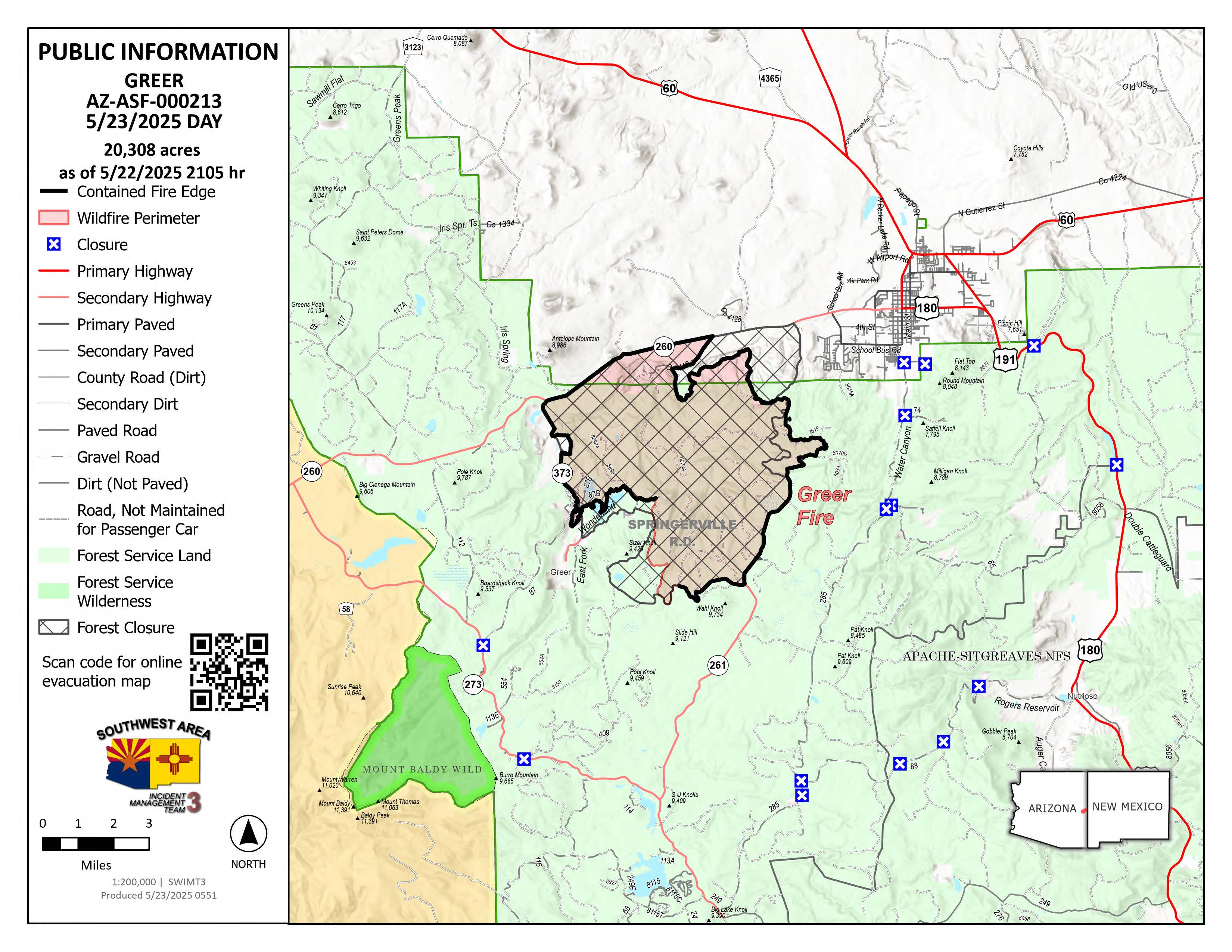
Greer Fire Daily Update 05 23 2025
Related Incident: Greer Fire
Publication Type: News
Southwest Complex Incident Management Team transitions to local type 3 team
Acres: 20,308
Start Date: May 13, 2025
Location: Greer, AZ
Cause: Under Investigation
Personnel: Approximately 252
Fuels: Grass, Shrubs, Timber
Containment: 88 percent
Operations: Extensive suppression repair work has occurred the past few days with little to no threat of fire crossing containment lines. A local type 3 organization will assume command of the fire tonight at 6 p.m. Today, the incoming type 3 incident commander is working closely with the team before they depart to ensure a smooth transition. This will be the final daily update from the incident management team. Future updates and information about the fire will be posted to Inciweb and the incident Facebook page through Memorial Day weekend. Southwest Complex Incident Management Team 3 is appreciative of the cooperation with local officials and the support from the public during their time managing the Greer Fire.
Weather: Near critical fire weather conditions are forecast today as temperatures remain hot and dry with wind gusts up to around 30-35mph.
Smoke: Smoke has significantly decreased over the fire area and surrounding towns with no affect on the communities.
Closures: The Apache-Sitgreaves National Forest has decreased the closure order for parts of the National Forest lands. Stage 2 Fire Restrictions are also in effect prohibiting fire, campfire, or stove fire, including charcoal briquettes and smoking.
Highway 260 and 261 are now open in both directions. For updated travel information: az511.com
Evacuations: To check current evacuation statuses, an interactive evacuation map is available from the QR code below. https://linktr.ee/GreerFire
Safety: We encourage the public to remember that a temporary flight restriction has been issued over the fire area. It is illegal to fly drones within the area.
Settings - change map background and toggle additional layers
Filter - control incident types displayed on map.
Zoom to your location
Reset map zoom and position
Could not determine your location.
Show Legend
 Wildfire
 Prescribed Fire
 Burned Area
Response
Burned Area
Response Other
Other
Horse River Fire
Unit Information
Incident Contacts
Settings - change map background and toggle additional layers
Filter - control incident types displayed on map.
Zoom to your location
Reset map zoom and position
Could not determine your location.
Show Legend
- Wildfire
- Prescribed Fire
- Burned Area
Response
- Other
Inn Fire 2025
Unit Information
Incident Contacts
Amended Greer Fire Incident Area and Road Emergency Closure 05 22 2025
Related Incident: Greer Fire
Publication Type: Closures
U.S. Department of Agriculture, U.S. Forest Service Apache-Sitgreaves National Forests Springerville Ranger District Amended Greer Fire Incident Area and Road Emergency Closure.
Full Closure Order
PROHIBITIONS
Pursuant to 16 U.S.C. § 551 and 36 C.F.R. § 261.50 (a) and (b), the following are prohibited on the National Forest System (NFS) roads, trails, and lands in the Springerville Ranger District, Apache-Sitgreaves National Forests, described below and shown on the attached map incorporated into this Order as Exhibit A (the “Described Area/Roads/Trails”):
- Public health or safety. 36 C.F.R. § 261.53(e)
- Being on the road. 36 C.F.R. § 261.54(e)
- Being on the trail. 36 C.F.R. § 261.55(a)
EXEMPTIONS
Pursuant to 36 C.F.R. § 261.50(e), the following persons are exempt from this Order:
- Persons with Forest Service Permit No. FS-7700-48 (Permit for Use of Roads, Trails, or Areas Restricted by Regulation or Oder), specifically exempting them from this Order or a written determination by a Forest Service authorized officer that a permit is not required under 36 C.F.R. § 251.50(e)(1) or (2).
- Any Federal, State, or Local Officer, or member of an organized rescue or firefighting resource in the performance of an official duty.
DESCRIBED AREA/ROADS/TRAILS
As shown in the map at Exhibit A, the Described Area encompasses all National Forest System lands, roads, and trails within the boundary at the junction of Hwy 260 and Hwy 261, following a southerly direction along Hwy 261 to National Forest System Road (NFSR) #409, then following NFSR #409 in a westerly direction to NFSR #8358, then following NFSR #8358 in a northerly direction to County Rd. 1126, then following County Rd. 1126 in a westerly direction to Hwy 373, then following Hwy 373 in a northerly direction to Hwy 260, then following Hwy 260 in a easterly direction to Hwy 261.
PURPOSE
The purpose of this Order is to provide for the public’s health and safety during periods of high or extreme fire danger with very limited escape routes out of the described area during the Greer Fire incident.
IMPLEMENTATION
- This Order shall be in effect from May 22, 2025, at 5:00 PM through September 30, 2025, at 8:00 AM, unless rescinded.
- A map identifying the Described Area, Roads, Trails is attached and made part of this Order as Exhibit A. For a digital version of this Order and Exhibit A, go to https://www.fs.usda.gov/alerts/asnf/alerts-notices.
- Unless otherwise expressly defined in this Order, the terms used in this Order are defined by the regulations of the Secretary of Agriculture, 36 C.F.R. Chapter II, Parts 200-299. If there are terms in this Order that are not expressly defined in the Order or 36 C.F.R. Chapter II, Parts 200-299, their meaning shall be determined by their plain language definitions.
- A violation of the above prohibitions is punishable as a Class B misdemeanor by a fine of not more than $5,000 for individuals and $10,000 for organizations, or by imprisonment for not more than six months, or both. 16 U.S.C. § 551; 18 U.S.C. §§ 3559, 3571, and 3581.
- Contact the Springerville Ranger District in Springerville, (928) 333-6200, and Apache-Sitgreaves National Forests Supervisor’s Office in Springerville (928) 333-6200, for more information about this Order.
- This Order supersedes any previous Orders prohibiting the same or similar acts in the same Described Area, Road, or Trail.
Signed and issued on this 22nd day of May, 2025.
Greer Fire Daily Update 05 22 2025
Related Incident: Greer Fire
Publication Type: News
Minimal hot spots, firefighters continue suppression repair
Acres: 20,308
Start Date: May 13, 2025
Location: Greer, AZ
Cause: Under Investigation
Personnel: Approximately 375
Fuels: Grass, Shrubs, Timber
Containment: 88 percent
Operations: Fire activity remains low as crews continue rehabilitating dozer and hand lines no longer needed for containment. Suppression repair crews are working rapidly to stabilize soils, restore drainage, and prevent long-term environmental damage. Fire managers emphasize that these efforts are crucial for protecting watersheds, reducing erosion, and supporting ecosystem recovery. As containment grows and work is completed, firefighters are rehabbing their equipment. Some are departing for home or to other fires.
Weather: Expect hotter and drier temperatures today over the fire area with wind gusts up to 25 mph.
Smoke: Smoke has significantly decreased over the fire area and surrounding towns.
Closures: The Apache-Sitgreaves National Forest has issued a closure order for parts of the National Forest lands. Stage 2 Fire Restrictions are also in effect prohibiting fire, campfire, or stove fire, including charcoal briquettes and smoking.
Highway 260 is open in both directions. For updated travel information: az511.com
Evacuations: All GO evacuation status’ have been decreased to SET. To check current evacuation statuses, an interactive evacuation map is available from the QR code below. https://linktr.ee/GreerFire
Safety: We encourage the public to remember that a temporary flight restriction has been issued over the fire area. It is illegal to fly drones within the area.

Camp House Jenkins Creek Fires Update May 22 2025 05 22 2025
Related Incident: Camp House FireJenkins Creek Fire
Publication Type: News
Camp House and Jenkins Creek Fires Update
Camp House Fire Quick Facts
Size: 12,071 acres Location: Brimson, MN
Personnel: 363 Start Date: 05/11/2025
Containment: 90% Cause: Under investigation
Camp House Fire: This fire initially started on private land on 5/11 and moved onto the Superior National Forest. Since the initial attack, a full-suppression and direct containment strategy has been utilized; and has proven very successful. Yesterday, firefighting crews and equipment working around the Camp House Fire made excellent progress on the entire perimeter of the fire’s footprint. Firefighters walking within the wildfire’s burned interior, near the line, continued to search for and put out smoldering stumps and roots.
Jenkins Creek Fire Quick Facts
Size: 16,748 acres Location: T57N R13W Section 3
Personnel: 226 Start Date:05/12/2025
Containment: 32% Cause: Human Caused
Jenkins Creek Fire: Firefighters continued to successfully add containment yesterday and overnight. The southern edge of the fire is now considered secure. Crews on both the east and west sides of the fire were able to connect control lines along each front. Unmanned Aerial Systems (UAS) continued to fly and assist firefighters in finding any areas that needed attention. The engines and crews dedicated to structure protection are expected to complete that work today. Two helicopters are available to assist crews with their work today. Heavy equipment doing chipping work is also nearing completion of the fuel break and fuel reduction work along Forest Road 113. While the initial investigation into the Jenkins Creek Fire indicates the fire is related to a human cause, the investigation is ongoing.
Evacuation, Road Closure, and Homeowner Access information for St. Louis County:
https://tinyurl.com/StLouisCoSituationMap. For Lake County: https://tinyurl.com/LakeCoMnEvacuationMap.
St. Louis County: Conditions improved enough that 13 evacuation zones that had been on “Go” were changed to “Set” status Tuesday night. Hwy-44 and CR-110/FH-11 reopened to through-traffic yesterday. Skibo Road and Forest Road 113 will remain closed eastbound from CR-110/FH-11. Bundle Lake Road is closed northbound from Hwy- 16/Town Line Rd.
Lake County: The Lake County Sherrif’s office announced that all evacuations were lifted yesterday.
National Weather Service Forecast: Clearing skies with a high of 57 and 37% humidity are expected today. Winds will be from the east, between 10 and 14 mph with gusts up to 27 mph.
Laurentian Ranger District closures: Emergency Forest Order 09-09-25-05 prohibits visitor entry to some camp sites and recreational areas. See Forest Order Exhibit A for a list of closure areas and Exhibit B for a map of the area. The closure may be modified or extended as conditions allow. https://www.fs.usda.gov/r09/superior/alerts/forest-order- 09-09-25-05-brimson-complex-emergency-closure
Current Burning Restrictions: https://www.dnr.state.mn.us/forestry/fire/firerating_restrictions.html
Public Reminder: “If you fly, we can’t”
When someone flies a drone near the fire, it creates a safety hazard that shuts down aerial operations.
Fire Information: 218-206-6805 9 a.m. to 8 p.m.
Inciweb: https://inciweb.wildfire.gov/incident-information/mnmns-camp-house
Email: 2025.camphouse@firenet.gov
Prescribed Burning to Continue Tomorrow at Masterson Rx 05 21 2025
Related Incident: 2025 Klamath NF Spring Prescribed Burning
Publication Type: Announcement
Crews had a successful day out at the Masterson Prescribed Burn today, accomplishing 30 acres of underburning in the wildland urban interface.
Klamath National Forest personnel were joined by crews from the Quartz Valley Indian Reservation, the Six Rivers National Forest, and the Mendocino National Forest to help implement the burn.
An engine is assigned to patrol the burn unit through the night.
Some smoke may be present in the area tonight as fuels within the burn unit continue to consume. Motorists should watch for smoke on the Gazelle-Callahan Road.
Burn operations are set to continue tomorrow, Thursday, May 22, if fuel and weather conditions allow. Up to 110 acres are slated for burning tomorrow.
Settings - change map background and toggle additional layers
Filter - control incident types displayed on map.
Zoom to your location
Reset map zoom and position
Could not determine your location.
Show Legend
- Wildfire
- Prescribed Fire
- Burned Area
Response
- Other
Cody Fire
Unit Information
Incident Contacts
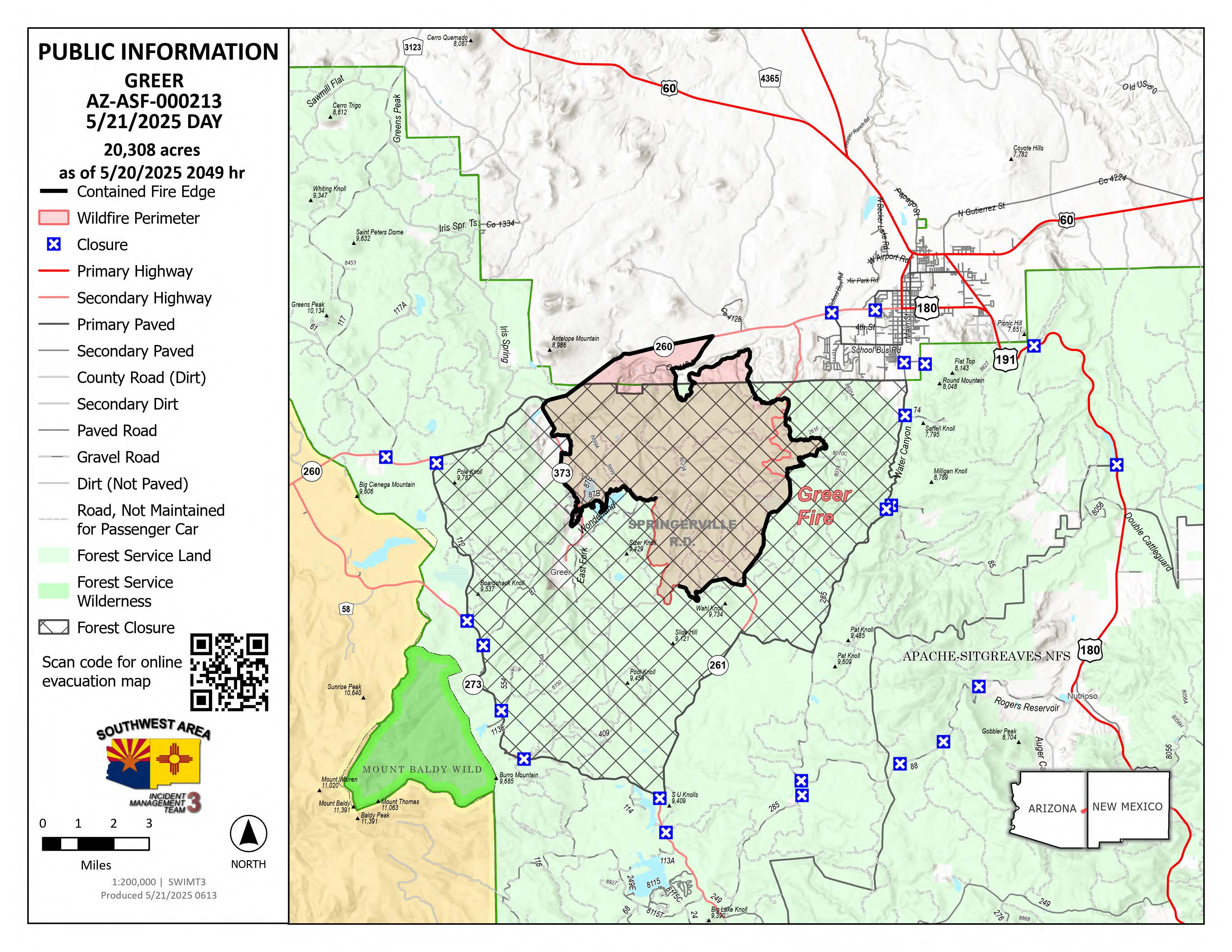
Greer Fire Daily Update 05 21 2025
Related Incident: Greer Fire
Publication Type: News
Suppression repair well underway as containment increases
Acres: 20,308
Start Date: May 13, 2025
Location: Greer, AZ
Cause: Under Investigation
Personnel: Approximately 513
Fuels: Grass, Shrubs, Timber
Containment: 88 percent
Highlights: Mandatory evacuation orders were lifted Monday night as containment increases along the fire.
Operations: Yesterday, milder winds helped firefighters secure more of the fire’s eastern edge. As a result, additional containment has been reflected on the map, and fire managers remain confident that the fire will stay within its current footprint.
Today, firefighters continue to patrol and mop up remaining hotspots, with a focus on Division Romeo in the southern section. Suppression repair is also ongoing along all edges of the fire, including chipping remaining debris left from line preparation during last week’s firing operations.
Weather: Gradual warming and drying is expected to continue over the fire for the next few days, with the warmest day of the period coming on Thursday. Winds will be weaker, with gusts to around 25 mph on Wednesday and Thursday.
Smoke: Smoke forecast at https://www.azdeq.gov/wildfire/forecast/greerfire
Closures: The Apache-Sitgreaves National Forest has issued a closure order for parts of the National Forest lands. Stage 2 Fire Restrictions are also in effect prohibiting fire, campfire, or stove fire, including charcoal briquettes and smoking.
Highway 260 is open in both directions. For updated travel information: az511.com
Evacuations: All GO evacuation status’ have been decreased to SET. To check current evacuation statuses, an interactive evacuation map is available from the QR code below. https://linktr.ee/GreerFire
Safety: We encourage the public to remember that a temporary flight restriction has been issued over the fire area. It is illegal to fly drones within the area.
Camp House Jenkins Creek Fires Update May 21 2025 05 21 2025
Related Incident: Camp House FireJenkins Creek Fire
Publication Type: News
Camp House and Jenkins Creek Fires Update
Camp House Fire Quick Facts
Size:12,071 acres Location: Brimson, MN
Personnel: 365 Start Date: 05/11/2025
Containment: 73% Cause: Under investigation
Camp House Fire: Firefighters’ steady effort in battling the Camp House Fire over the past week paid off as all existing lines held despite strong winds from the east. Overnight precipitation continued to aid in cooling the fire. Two hotshot crews will continue to work in some of the more challenging terrain to finish connecting portions of the containment line. Other crews will begin moving deeper into the interior from the southern end of the fire to find and put out any smoldering areas inside the containment line. The fire initially started on private land and moved into national forest system lands; a Forest closure (more information below) remains in effect.
Jenkins Creek Fire Quick Facts
Size:16,748 acres Location: T57N R13W Section 3
Personnel: 223 Start Date: 05/12/2025
Containment: 13% Cause: Human-caused
Jenkins Creek Fire: Crews held line around the fire despite the strong, gusting winds. Unmanned Aerial Systems (UAS) flew five flights during breaks in the wind, detecting areas with heat that were then attacked by ground crews. Today, additional firefighters will be moved from the Camp House Fire to the Jenkins Fire to make a push to connect existing containment lines. The heavy equipment that was working along the southern edge of the fire to masticate (chop up) large fallen debris into wood chips will progress north today. The debris that is chipped up will not burn as hot should fire reach the wood chippings. Over time, the woody chip debris will decompose quicker. While the initial investigation into the Jenkins Creek Fire indicates the fire is related to a human cause, the investigation is ongoing.
Evacuation, Road Closure, and Homeowner Access information for St. Louis County:
https://tinyurl.com/StLouisCoSituationMap. For Lake County: https://tinyurl.com/LakeCoMnEvacuationMap.
Effective Wednesday, May 21, at 8 a.m. Conditions have improved enough that 13 evacuation zones that had been on “Go” status are being improved to “Set” status (zones 1-5, 9-12, and 17-20). Nine zones that had been on “Set” status are being improved to “Ready” status. (6-8, 13-16, 21-22). Please check the evacuation map if you’re not sure which zone you’re in. https://slcgis.maps.arcgis.com/.../lookup/index.html.
Hwy-44 and CR-110/FH-11 are reopening to through-traffic. Skibo Road and Forest Road 113 will remain closed eastbound from CR-110/FH-11. Bundle Lake Road is closed northbound from Hwy-16/Town Line Rd. Property owners are urged to take extra caution in the area. Be aware that the burned areas may still show smoke from various stumps and debris - this is not of concern when inside the already burned area.
National Weather Service Forecast: Clearing skies with a high of 57 and 37% humidity are expected today. Winds will be from the east, between 10 and 14 mph with gusts up to 27 mph.
Laurentian Ranger District closures: Emergency Forest Order 09-09-25-05 prohibits visitor entry to some camp sites and recreational areas. See Forest Order Exhibit A for a list of closure areas and Exhibit B for a map of the area. The closure may be modified or extended as conditions allow. https://www.fs.usda.gov/r09/superior/alerts/forest-order- 09-09-25-05-brimson-complex-emergency-closure
Current Burning Restrictions: https://www.dnr.state.mn.us/forestry/fire/firerating_restrictions.html
Fire Information: 218-206-6805 9 a.m. to 8 p.m.
Inciweb: https://inciweb.wildfire.gov/incident-information/mnmns-camp-house
Email: 2025.camphouse@firenet.gov