
Camp House Jenkins Creek Fires Update May 21 2025 05 21 2025
Related Incident: Camp House FireJenkins Creek Fire
Publication Type: News
Camp House and Jenkins Creek Fires Update
Camp House Fire Quick Facts
Size:12,071 acres Location: Brimson, MN
Personnel: 365 Start Date: 05/11/2025
Containment: 73% Cause: Under investigation
Camp House Fire: Firefighters’ steady effort in battling the Camp House Fire over the past week paid off as all existing lines held despite strong winds from the east. Overnight precipitation continued to aid in cooling the fire. Two hotshot crews will continue to work in some of the more challenging terrain to finish connecting portions of the containment line. Other crews will begin moving deeper into the interior from the southern end of the fire to find and put out any smoldering areas inside the containment line. The fire initially started on private land and moved into national forest system lands; a Forest closure (more information below) remains in effect.
Jenkins Creek Fire Quick Facts
Size:16,748 acres Location: T57N R13W Section 3
Personnel: 223 Start Date: 05/12/2025
Containment: 13% Cause: Human-caused
Jenkins Creek Fire: Crews held line around the fire despite the strong, gusting winds. Unmanned Aerial Systems (UAS) flew five flights during breaks in the wind, detecting areas with heat that were then attacked by ground crews. Today, additional firefighters will be moved from the Camp House Fire to the Jenkins Fire to make a push to connect existing containment lines. The heavy equipment that was working along the southern edge of the fire to masticate (chop up) large fallen debris into wood chips will progress north today. The debris that is chipped up will not burn as hot should fire reach the wood chippings. Over time, the woody chip debris will decompose quicker. While the initial investigation into the Jenkins Creek Fire indicates the fire is related to a human cause, the investigation is ongoing.
Evacuation, Road Closure, and Homeowner Access information for St. Louis County:
https://tinyurl.com/StLouisCoSituationMap. For Lake County: https://tinyurl.com/LakeCoMnEvacuationMap.
Effective Wednesday, May 21, at 8 a.m. Conditions have improved enough that 13 evacuation zones that had been on “Go” status are being improved to “Set” status (zones 1-5, 9-12, and 17-20). Nine zones that had been on “Set” status are being improved to “Ready” status. (6-8, 13-16, 21-22). Please check the evacuation map if you’re not sure which zone you’re in. https://slcgis.maps.arcgis.com/.../lookup/index.html.
Hwy-44 and CR-110/FH-11 are reopening to through-traffic. Skibo Road and Forest Road 113 will remain closed eastbound from CR-110/FH-11. Bundle Lake Road is closed northbound from Hwy-16/Town Line Rd. Property owners are urged to take extra caution in the area. Be aware that the burned areas may still show smoke from various stumps and debris - this is not of concern when inside the already burned area.
National Weather Service Forecast: Clearing skies with a high of 57 and 37% humidity are expected today. Winds will be from the east, between 10 and 14 mph with gusts up to 27 mph.
Laurentian Ranger District closures: Emergency Forest Order 09-09-25-05 prohibits visitor entry to some camp sites and recreational areas. See Forest Order Exhibit A for a list of closure areas and Exhibit B for a map of the area. The closure may be modified or extended as conditions allow. https://www.fs.usda.gov/r09/superior/alerts/forest-order- 09-09-25-05-brimson-complex-emergency-closure
Current Burning Restrictions: https://www.dnr.state.mn.us/forestry/fire/firerating_restrictions.html
Fire Information: 218-206-6805 9 a.m. to 8 p.m.
Inciweb: https://inciweb.wildfire.gov/incident-information/mnmns-camp-house
Email: 2025.camphouse@firenet.gov
Settings - change map background and toggle additional layers
Filter - control incident types displayed on map.
Zoom to your location
Reset map zoom and position
Could not determine your location.
Show Legend
 Wildfire
 Prescribed Fire
 Burned Area
Response
Burned Area
Response Other
Other
Cedar Fire
Unit Information
Incident Contacts
Prescribed Burning at Masterson Loop on the SalmonScott District Scheduled for May 21 2025 05 20 2025
Related Incident: 2025 Klamath NF Spring Prescribed Burning
Publication Type: Announcement
Crews from the Salmon Scott River Ranger District are planning to implement a prescribed burn beginning Wednesday, May 21st at Masterson Loop if conditions allow. The project area is located approximately four miles east of Callahan, CA. Fire crews will target up to 160 acres for burning utilizing aerial ignition via an unmanned aircraft system as the lighting method.
The project area is strategically integrated with a network of fuel reduction treatments along adjacent ridgelines in the Klamath National Forest. These treatments, developed through collaborative efforts with regional partners, form a cohesive fuel break system extending across the rugged terrain northwest of Callahan. This interconnected landscape-scale strategy enhances wildfire protection for nearby communities, infrastructure, and natural resources by creating barriers that can be leveraged during fire events.
Smoke from this project will be visible from Callahan.
Motorists should exercise caution when driving in areas of smoke – turn on headlights, reduce speed, and keep an eye out for personnel and apparatus that may be working alongside the road.
Settings - change map background and toggle additional layers
Filter - control incident types displayed on map.
Zoom to your location
Reset map zoom and position
Could not determine your location.
Show Legend
- Wildfire
- Prescribed Fire
- Burned Area
Response
- Other
2025 Upper Peninsula Fire and Aviation Management Unit Planned Prescribed Fires - East Zone
Unit Information
Incident Contacts
Settings - change map background and toggle additional layers
Filter - control incident types displayed on map.
Zoom to your location
Reset map zoom and position
Could not determine your location.
Show Legend
- Wildfire
- Prescribed Fire
- Burned Area
Response
- Other
2025 Upper Peninsula Fire and Aviation Management Unit Planned Prescribed Fires - West Zone
Unit Information
Incident Contacts
Settings - change map background and toggle additional layers
Filter - control incident types displayed on map.
Zoom to your location
Reset map zoom and position
Could not determine your location.
Show Legend
- Wildfire
- Prescribed Fire
- Burned Area
Response
- Other
2025 Upper Peninsula Fire and Aviation Management Unit Planned Prescribed Fires
Unit Information
Incident Contacts
Greer Fire Daily Update 05 20 2025
Related Incident: Greer Fire
Publication Type: News
Evacuation levels downgraded, residents begin returning home
Acres: 20,308
Start Date: May 13th, 2025
Location: Greer, AZ
Cause: Under Investigation
Personnel: Approximately 676
Fuels: Grass, Shrubs, Timber
Containment: 55 percent
Highlights: All “GO” evacuation orders have been downgraded to “SET” status, lifting current restrictions and allowing residents to safely return to their homes.
Operations: Yesterday, another round of strong winds tested the fire's containment, but all control lines remained secure thanks to the extensive efforts of firefighters working along the perimeter. Overnight, crews continued patrolling the fire lines and extinguishing visible heat sources to prevent any flare-ups.
Today, firefighters are initiating a suppression repair plan focused on rehabilitating dozer and hand lines that are no longer needed for containment. Crews and engines are also continuing interior mop-up operations extinguishing hot spots deeper within the fire area to reduce the risk of embers breaching containment lines and to strengthen control along the fire’s edge. A community meeting was broadcasted on the incidents YouTube page that includes many questions and answers regarding repopulation, forest closures, and current road closures. www.youtube.com/@greerfire2025
Weather: High pressure begins to build in over the region today, which will lead to several days in row of lighter winds but continued dry and warmer conditions.
Smoke: Updated smoke forecast at https://www.azdeq.gov/wildfire/forecast/greerfire
Closures: The Apache-Sitgreaves National Forest has issued a closure order for parts of the National Forest lands. Stage 2 Fire Restrictions are also in effect prohibiting fire, campfire, or stove fire, including charcoal briquettes and smoking.
Evacuations: All GO evacuation status’ have been decreased to SET. To check current evacuation statuses, an interactive evacuation map is available from the QR code below.
Shelter for evacuees are open at the County Fairgrounds in St. Johns and the Alpine Community Center.
Highway 260 has reopened near Greer. For updated travel information: az511.com
Safety: A temporary flight restriction has been issued over the fire area. It is illegal to fly drones within the area.
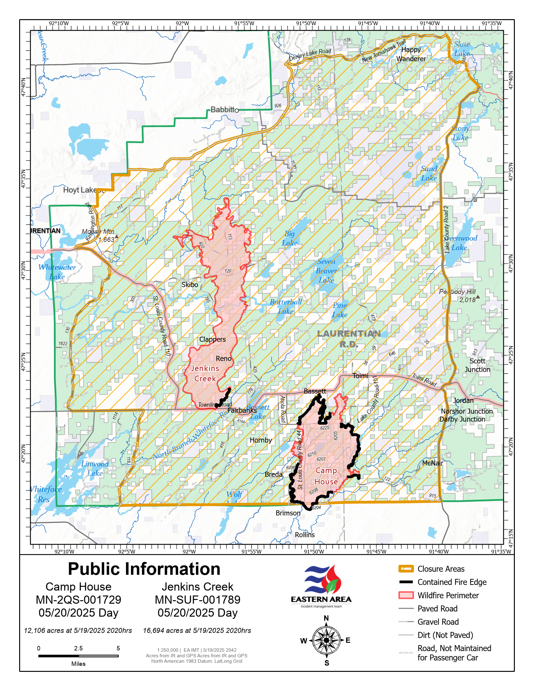
Camp House Jenkins Creek Fires Update May 20 2025 05 20 2025
Related Incident: Camp House FireJenkins Creek Fire
Publication Type: News
Camp House and Jenkins Creek Fires Update
Yesterday’s Community Meeting: Thank you to everyone that attended the Jenkins Creek and Camp House Fires community meeting last night in Aurora. Over 150 people attended. We apologize to anyone who tried to log in to the livestream link – technical issues occurred. A recording of the meeting will be posted today on the EA IMT Facebook page. Also, the meeting can viewed on WDIO’s website.
Camp House Fire Quick Facts
Size: 12,106 acres Location: Brimson, MN
Personnel: 394 Start Date: 05/11/2025
Containment: 59% Cause: Under investigation
Camp House Fire: Containment lines continued to be built and strengthened around the perimeter of the Camp House Fire yesterday in preparation for today’s windy conditions. Crews and dozers worked around all areas of the fire, either enhancing the containment line or finding and extinguishing hot spots. Helicopter and Unmanned Aerial Systems (UAS) supported firefighters on the ground to achieve these objectives. Masticator equipment was used along the south end to grind down and remove fallen trees, and will continue through today. All firefighters will be focused on maintaining containment lines and catching any flare-ups with today’s strong and gusty winds.
Jenkins Creek Fire Quick Facts
Size: 16,694 acres Location: T57N R13W Section 3
Personnel: 227 Start Date: 05/12/2025
Containment: 6% Cause: Under investigation
Jenkins Creek Fire: Crews made good progress in establishing lines around the fire over the past few days. Firefighters assigned to a Structure Protection group established a firefighting plan for Skibo and Hoyt Lakes in case the fire advances in that direction. This work included adding fuel breaks and setting hose lays vital to slowing fire spread. Crews will continue to work along the entire perimeter of the fire today. More resources will be assigned to the western side of the fire to provide initial attack capabilities in the event of flare-ups triggered by today’s gusty winds.
Evacuation, Road Closure, and Homeowner Access information for St. Louis County: https://tinyurl.com/StLouisCoSituationMap. For Lake County: https://tinyurl.com/LakeCoMnEvacuationMap. Additional changes to evacuation levels and road closures were announced by the St. Louis County Sheriff yesterday.
Brimson Road is now open to through traffic. The section of Hwy 44 south from Brimson Road is also open to through-traffic. Hwy 44 north from Brimson Road remains closed to Town Line Road. Additionally, Evacuation Zone 6 was downgraded to “Set” status. Vehicles should avoid stopping anywhere in the evacuation “Go” zones to minimize exposure and risk. Drivers are also asked to take extra caution due to the continued presence of emergency crews, utility crews, and other curious or distracted drivers.
National Weather Service Forecast: A wind advisory is in effect until 1 a.m. tonight. A red flag warning has been issue for St. Louis County today from noon to 9 p.m. Sunny skies with a high of 51 and 23% humidity. Winds will be from the east at a steady 6 to 16 mph, gusting to 42 mph. Laurentian Ranger District closures: Emergency Forest Order 09-09-25-05 prohibits visitor entry to some camp sites and recreational areas. See Forest Order Exhibit A for a list of closure areas and Exhibit B for a map of the area. The closure may be modified or extended as conditions allow. https://www.fs.usda.gov/r09/superior/alerts/forest-order-09-09-25-05-brimson-complex-emergency-closure
Current Burning Restrictions: https://www.dnr.state.mn.us/forestry/fire/firerating_restrictions.html
Amended Greer Fire Incident Area and Road Emergency Closure 05 19 2025
Related Incident: Greer Fire
Publication Type: Closures
U.S. Department of Agriculture, U.S. Forest Service Apache-Sitgreaves National Forests Springerville Ranger District Amended Greer Fire Incident Area and Road Emergency Closure
PROHIBITIONS
Pursuant to 16 U.S.C. § 551 and 36 C.F.R. § 261.50 (a) and (b), the following are prohibited on the National Forest System (NFS) roads, trails, and lands in the Springerville Ranger District, Apache-Sitgreaves National Forests, described below and shown on the attached map incorporated into this Order as Exhibit A (the “Described Area/Roads/Trails”):
- Public health or safety. 36 C.F.R. § 261.53(e)
- Being on the road. 36 C.F.R. § 261.54(e)
- Being on the trail. 36 C.F.R. § 261.55(a)
EXEMPTIONS
Pursuant to 36 C.F.R. § 261.50(e), the following persons are exempt from this Order:
- Persons with Forest Service Permit No. FS-7700-48 (Permit for Use of Roads, Trails, or Areas Restricted by Regulation or Oder), specifically exempting them from this Order or a written determination by a Forest Service authorized officer that a permit is not required under 36 C.F.R. § 251.50(e)(1) or (2).
- Any Federal, State, or Local Officer, or member of an organized rescue or firefighting resource in the performance of an official duty.
DESCRIBED AREA/ROADS/TRAILS
As shown in the map at Exhibit A, the Described Area encompasses all National Forest System lands, roads, and trails within the boundary at the junction of Hwy 260 and School Bus Rd, following a southerly and westerly direction along School Bus Rd to S. Water Canyon Rd, then south along Water Canyon Rd/National Forest System Road (NFSR) #285, then following NFSR #285 in a southerly direction to NFSR #90, then following NFSR #90 in a westerly direction to Hwy 261, then following a southerly direction along Hwy 261 to Hwy 273, then following a westerly and northerly direction along Hwy 273 to NFSR #554, then following a northerly direction to Winn Campground to exclude Winn campground from the closure, and back in a southerly direction to Hwy 273, then following in a northerly direction along Hwy 273 to NFSR #112, then following a northerly direction along NFSR #112 to Hwy 260, then following an easterly direction along Hwy 260 to School Bus Rd.
PURPOSE
The purpose of this Order is to provide for the public’s health and safety during periods of high or extreme fire danger with very limited escape routes out of the described area during the Greer Fire incident.
IMPLEMENTATION
- This Order shall be in effect from May 19, 2025, at 5:00 PM through September 30, 2025, at 8:00 AM, unless rescinded.
- A map identifying the Described Area, Roads, Trails is attached and made part of this Order as Exhibit A. For a digital version of this Order and Exhibit A, go to https://www.fs.usda.gov/alerts/asnf/alerts-notices.
- Unless otherwise expressly defined in this Order, the terms used in this Order are defined by the regulations of the Secretary of Agriculture, 36 C.F.R. Chapter II, Parts 200-299. If there are terms in this Order that are not expressly defined in the Order or 36 C.F.R. Chapter II, Parts 200-299, their meaning shall be determined by their plain language definitions.
- A violation of the above prohibitions is punishable as a Class B misdemeanor by a fine of not more than $5,000 for individuals and $10,000 for organizations, or by imprisonment for not more than six months, or both. 16 U.S.C. § 551; 18 U.S.C. §§ 3559, 3571, and 3581.
- Contact the Springerville Ranger District in Springerville, (928) 333-6200, and Apache-Sitgreaves National Forests Supervisor’s Office in Springerville (928) 333-6200, for more information about this Order.
- This Order supersedes any previous Orders prohibiting the same or similar acts in the same Described Area, Road, or Trail.
Signed and issued on this 19th day of May, 2025.
Munger Shaw Fire Update 05 19 2025
Related Incident: Munger Shaw Fire
Publication Type: News
Munger Shaw Fire Quick Facts
Size: 1259 acres Location: Southeast of Cotton, MN Personnel: 29
Containment: 95% Cause: Under investigation Resources: 2 engines, 1 UAS module.
Start Date: 05/12/2025
KEY MESSAGE: This will be the final update for the Munger Shaw Fire unless significant activity occurs. Over the weekend, firefighters made great progress with improved weather conditions toward containing the Munger Shaw Fire -- now 95% contained. MNICS Team A will be transitioning the management of the fire back to the local Cloquet Area DNR Forestry at 6:00 a.m. tomorrow. After today, the fire organization will be approximately 3-5 people issued to the fire. The Minnesota DNR will continue monitoring and patrolling the fire area. While the fire is largely contained, smoldering hotspots within the fire’s interior may continue to smolder and produce smoke until the fire area receives sufficient precipitation.
Update and Planned Activities:
The un-crewed aircraft system (UAS) or drone finished mapping the fire perimeter yesterday and reported the fire size has decreased to 1259 acres due to more accurate mapping. The advanced infrared technology used by the drone identified a few remaining hotspots within the burn area. Crews have worked to cool these hotspots down using water and stirring the hots embers to the surface. Drone use by the public near a wildfire is illegal. Unauthorized drones pose a serious threat to pilot safety.
Despite the rainy conditions yesterday, crews with tracked vehicles successfully completed all of their repair objectives. Suppression damage repair includes cleaning up any resource damage resulting from fire control lines, roads, trails, staging areas, safety zones, and drop points.
Today, firefighters will continue to patrol and monitor the fire’s perimeter.
National Weather Service Forecast:
High winds and low relative humidities will lead to drying conditions on the fire today. Winds will be from the east at 5 to 10 mph, increasing throughout the day with gusts between 25 to 30 mph. East winds will remain strong and gusty through Tuesday. Temperatures will be cool with a predicted high of 48 degrees.
Evacuations and Road Closures: Road closures and evacuations have been rescinded by the Sheriff. The team is closely coordinating with St. Louis County on updating the evacuation status. Stay alert and continue to monitor county websites for information. St. Louis County Sheriff's Office Divisions of Emergency Management and 911 have a website hub with evacuation and other fire information and Ready-Set-Go map.
St. Louis County: https://sheriff-slcgis.hub.arcgis.com/pages/wildfire
Cooperating Agencies: Minnesota Department of Natural Resources, Bureau of Indian Affairs, US Fish and Wildlife Service, USDA Forest Service, CN Railroad, Northland Fire Department, St. Louis County Emergency Management and St. Louis County Rescue Squad and the American Red Cross.
Burning Restrictions: For current burning restrictions, see https://www.dnr.state.mn.us/forestry/fire/firerating_restrictions.html