
Jenkins Creek and Camp House Fires Community Meeting Announcement for May 19 2025 05 18 2025
Related Incident: Jenkins Creek Fire
Publication Type: Announcement
Jenkins Creek and Camp House Fires Community Announcement
When: Monday, May 19, 2025 @ 6:00 pm
Where: Mesabi East School District Auditorium
A community meeting will be held for the Jenkins Creek and Camp House Road Fires on Monday, May 19th at 6 pm at the Mesabi East School District High School Auditorium, 601 N 1st St W, Aurora, MN.
Representatives of the Eastern Area Incident Management Team, the US Forest Service, the Minnesota DNR and the St Louis County Sheriff's Department will present information on the status of the two fires, and the related closures and evacuations.
A link to watch the meeting online will be provided on Monday.
Greer Fire Daily Update 05 18 2025
Related Incident: Greer Fire
Publication Type: News
Fire edge tested under critical weather conditions
Acres: 19, 121 Start Date: May 13, 2025
Location: Greer, AZ Cause: Under Investigation
Personnel: Approximately 680 Fuels: Grass, Shrubs, Timber
Containment: 0 percent
Highlights: Today high winds will be another test for firefighters holding the firelines.
Operations: Firing operations completed on Friday along HWY 260, State Route 261, and Forest Rd 409 proved to be successful yesterday as winds tested the fire’s edge. Crews were able to continue the largest remaining firing operation last night that connected Forest Rd 409 to the main fire on the south/southwestern edge. Today, all resources continue to secure the fire’s edge to prevent wind-blown embers from spreading the fire.
Fire managers continually coordinate with Navopache Electric Cooperative to assess when it is safe to re-energize evacuated areas without power. The integrity of power lines and poles are still being tested from critical winds and potential damage from the fire. The incident management team’s goal, in coordination with the county emergency management and sheriff’s office is to re-populate and re-energize evacuated areas immediately once it is safe. Yesterday, a small area of heat crossed the line off Forest Road 373 north of Greer, illustrating how high winds continue to challenge control efforts. Numerous areas of residual heat remain close to the fireline and structures, where pockets of unburned fuel may ignite. To re-populate and increase containment, fire managers must ensure control lines are holding and hotspots near the perimeter are fully extinguished.
Weather: Fire personnel are preparing for another Red Flag Warning in effect today with critical fire weather conditions and strong winds expected – including gusts up to 41 mph.
Smoke: Updated smoke forecast at https://www.azdeq.gov/wildfire/forecast/greerfire
Closures: The Apache-Sitgreaves National Forest has issued a closure order for parts of the National Forest lands. Stage 2 Fire Restrictions are also in effect prohibiting fire, campfire, or stove fire, including charcoal briquettes and smoking.
Evacuations: To check current evacuation statuses, an interactive evacuation map is available from the QR code below.
Shelter for evacuees are open at the County Fairgrounds in St. Johns and the Alpine Community Center.
Highway 260 is closed in both directions near Greer. For updated travel information: az511.com
Safety: A temporary flight restriction has been issued over the fire area. It is illegal to fly drones within the area.
Jenkins Creek Fire Daily Update for May 18 2025 05 18 2025
Related Incident: Jenkins Creek Fire
Publication Type: News
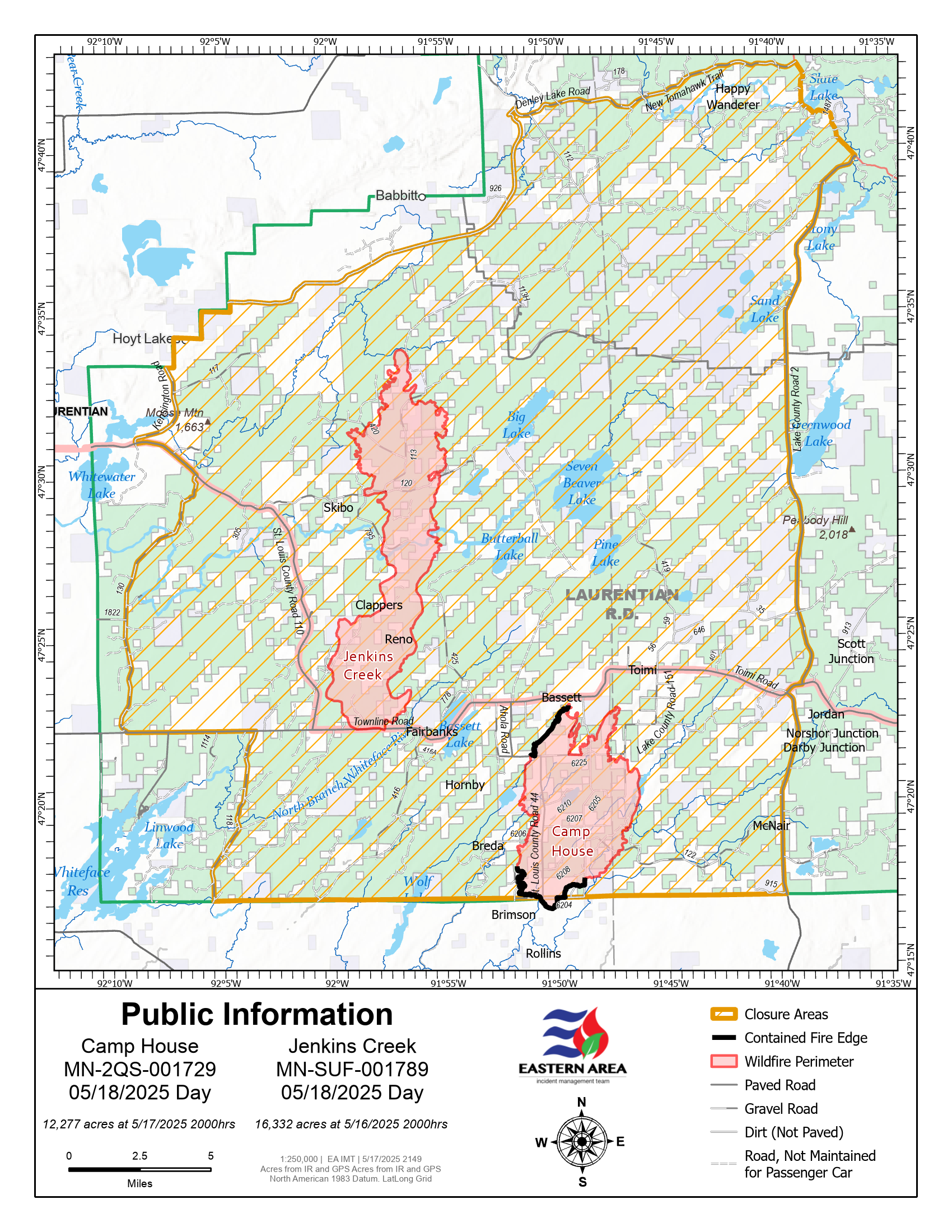
Jenkins Creek Fire Quick Facts
Size: 16,332 acres Location: T57N R13W Section 3
Personnel: 193 Start Date: 05/12/2025
Containment: 0% Cause: Under investigation
Jenkins Creek Fire: Protection of the Skibo and Hoyt Lakes communities remains a priority objective. On Saturday, firefighters and dozer operators extended fire containment lines along the northwest edge and southern end of the fire. Adding to existing hose lays and prioritizing structure protection in this area will continue today in preparation for the return of potential drier and gustier conditions this week.
Evacuation, Road Closure, and Homeowner Access information for St. Louis County: https://tinyurl.com/StLouisCoSituationMap. For Lake County: https://tinyurl.com/LakeCoMnEvacuationMap. Homeowners and property owners will have access to their properties from 10:00 a.m. until noon today (Sunday). Check in with sheriffs’ deputies at Hugo’s or the intersection of CR 16 and Forest Hwy 11, and bring proof of residency or ownership, and call 2-1-1 to report your exit from the evacuation zone. Hoyt Lake residents remain at the “Set” level of preparedness for now.
Community Meeting: A meeting for the Jenkins Creek and Camp House Fires will be held on Monday 5/18 at 6 p.m. at the Mesabi East School District High School Auditorium: 601 N 1st St W, Aurora, MN. The meeting will be live-streamed, and a link will be shared on the MNICS and Superior National Forest Facebook pages.
National Weather Service Forecast: Some morning showers are expected today. Temperatures will be cool, with a high of 46 and an overnight low of 29 degrees. Light winds will be out of the north-northeast at around 6 to 9 mph, with gusts of around 15 mph.
Portions of the Laurentian Ranger District are closed. Emergency Forest Order 09-09-25-05 prohibits visitor entry to some camp sites and recreational areas. See Forest Order Exhibit A for a list of closure areas and Exhibit B for a map of the area. The closure may be modified or extended as conditions allow. https://www.fs.usda.gov/r09/superior/alerts/forest-order-09-09-25-05-brimson-complex-emergency-closure
Current Burning Restrictions: https://www.dnr.state.mn.us/forestry/fire/firerating_restrictions.html
Camp House Jenkins Creek Fires Update May 18 2025 05 18 2025
Related Incident: Camp House Fire
Publication Type: News
Camp House Fire Update
Eastern Area Complex Incident Mgt. Team Incident Commander: Brian Jenkins (effective 05/14/2025)
Fire Information: 218-206-6805 9 a.m. to 8 p.m.
Inciweb: https://inciweb.wildfire.gov/incident-information/mnmns-camp-house Email: 2025.camphouse@firenet.gov
Camp House Fire Quick Facts
Size: 13,407 acres Location: Brimson, MN Personnel: 329
Containment: 31% Cause: Under investigation
Start Date: 05/11/2025
Camp House Fire: Yesterday provided favorable conditions for crews and dozers to build containment lines on the south end and west side of the fire. Firefighters will continue to work from these areas to strengthen line on the east and north sides of the fire today. Dead and distressed trees and downed power lines continue to pose significant hazards for firefighters. Crews will use infrared technology to identify and extinguish “hot spots” within the fire’s current perimeter. This fire has not grown in the past four days. Cool temperatures and precipitation have been beneficial in battling the fire, but dry conditions and strong, shifting winds are forecast for the coming days. As a result of the weather yesterday, fire activity was relatively low.
Evacuation, Road Closure, and Homeowner Access information for St. Louis County: https://tinyurl.com/StLouisCoSituationMap. For Lake County: https://tinyurl.com/LakeCoMnEvacuationMap. Homeowners and property owners will have access to their properties from 10:00 a.m. until noon today (Sunday). Check in with sheriffs’ deputies at Hugo’s or the intersection of CR 16 and Forest Hwy 11, and bring proof of residency or ownership, and call 2-1-1 to report your exit from the evacuation zone. Hoyt Lake residents remain at the “Set” level of preparedness for now.
Community Meeting: A meeting for the Jenkins Creek and Camphouse Road wildfires will be held on Monday 5/18 at 6 p.m., at the Mesabi East School District High School Auditorium—601 N 1st St W, Aurora, MN. The meeting will be live-streamed, and a link will be shared on the MNICS and Superior National Forest Facebook Pages.
National Weather Service Forecast: Some morning showers are expected today. Temperatures will be cool, with a high of 46 and an overnight low of 29 degrees. Light winds will be out of the north-northeast at around 6 to 9 mph, with gusts of around 15 mph.
Portions of the Laurentian Ranger District are closed. Emergency Forest Order 09-09-25-05 prohibits visitor entry to some camp sites and recreational areas. See Forest Order Exhibit A for a list of closure areas and Exhibit B for a map of the area. The closure may be modified or extended as conditions allow. https://www.fs.usda.gov/r09/superior/alerts/forest-order-09-09-25-05-brimson-complex-emergency-closure
Current Burning Restrictions: https://www.dnr.state.mn.us/forestry/fire/firerating_restrictions.html
Black Swamp Fire Daily Update 05 18 2025
Related Incident: Black Swamp Fire
Publication Type: News
NEW BERN, N.C., May 18, 2025 – This will be the last daily update for the Black Swamp Fire on the Croatan National Forest. Firefighters on the Black Swamp continue steadily increasing containment. The fire remains at 950-acre footprint, with 87% containment and 67 personnel.
Firefighters will continue pumping water into the fire area to fully saturate the soil, limiting the risk of fire growth as fuels dry. Mop up will continue around the fire perimeter, working steadily to fully contain the fire. Unused equipment will be backhauled from the fire area so it can be cleaned and stored for future firefighting efforts. Heavy equipment will be used to improve ditches and repair roads to return the environment to pre-fire conditions. This effort, known as “suppression repair,” limits disturbance to the area and aid in response to future fires in the area. Crews will continue to monitor the fire’s activity and adjust strategy if needed.
All Forest Closures remain in place, as firefighters are still accessing the area. To keep firefighters and the public safe, please abide by all closures in effect for Black Swamp Road, the Black Swamp OHV area, Great Lake Boating Access Area and Sheep Ridge Wilderness Area, as well as portions of Great Lake Road, Seaborn Road and Holston Hunter Road. Updates to closure areas will be posted on the National Forests in North Carolina on Facebook page at https://www.facebook.com/nfsnc.
For the latest wildfire updates, follow the National Forests in North Carolina on Facebook or visit https://www.fs.usda.gov/r08/northcarolina
Smoke from the fire can cause limited visibility and may impact local air quality. Please drive slowly and use caution on roads where smoke may be settling. Check for air quality alerts at https://airquality.climate.ncsu.edu/ or https://fire.airnow.gov.
The USDA Forest Service will continue working in close partnership with state and federal agencies as fire activity lessens and suppression repair begins, including the North Carolina Forest Service, U.S. Fish and Wildlife, North Carolina Wildlife Resource Commission and the National Park Service.
Fosythe II PM Update 05 17 2025
Related Incident: Forsythe II Prescribed Burn
Publication Type: Announcement
Ignitions have completed for the day after successfully treating 125 acres at the Forsythe II prescribed burn project. Fire crews will continue to work in the area, patrolling the project and ensuring a secure perimeter. In the interest of public and firefighter safety, a forest closure remains in effect for the area.
Smoke may continue to be visible in Front Range communities. Fire managers work closely with experts to minimize the impacts of smoke. Air quality is carefully monitored before and during a prescribed fire and all prescribed burns comply with state air quality regulations to minimize impacts to communities. To learn more about the potential health impacts of smoke visit www.colorado.gov/pacific/cdphe/wood-smoke-and-health.
Fire managers will continue to monitor local conditions for potential ignitions if conditions allow. Email notifications are sent out periodically during ignition periods. To receive these updates, make sure to join our email list. Additional information can be found here on InciWeb.
Camp House Jenkins Creek Fires Community Meeting Announcement May 19 2025 05 17 2025
Related Incident: Camp House Fire
Publication Type: Announcement
Camp House & Jenkins Creek Fires Community Announcement
When: Monday, May 19, 2025 @ 6:00 pm
Where: Mesabi East School District Auditorium
A community meeting will be held for the Jenkins Creek and Camp House Road Fires on Monday, May 19th at 6 pm at the Mesabi East School District High School Auditorium, 601 N 1st St W, Aurora, MN.
Representatives of the Eastern Area Incident Management Team, the US Forest Service, the Minnesota DNR and the St Louis County Sheriff's Department will present information on the status of the two fires, and the related closures and evacuations.
A link to watch the meeting online will be provided on Monday.
Forsythe II Midday Update 05 17 2025
Related Incident: Forsythe II Prescribed Burn
Publication Type: Announcement
Fire crews have successfully completed ignitions on the first unit area of 19 acres at the Forsythe II prescribed burn, and have begun working on their second unit area of 63 acres. In the interest of public and firefighter safety, the area remains closed to the public during operations.
Two local SEAT (Single Engine Airtanker) planes are conducting aerial training today, Saturday, May 17, in the area of Coffintop Mountain, located approximately 16 miles north of the Forsythe II project area. These aircraft are conducting proficiency practice flights and are not a part of the Forsythe II prescribed firing operations. They are in communication with fire crews in the area for situational awareness purposes.
Residents and visitors in the vicinity should continue to anticipate the presence of smoke during these prescribed burning operations. The smoke is most likely to be visible in the following areas: Lakeshore Subdivision, Crescent Village, Crescent Meadows, Gross Reservoir, Walker Mountain Ranch Park, Miramonte, Wondervu, Eldorado State park and various areas within Eastern Boulder County.
Additional email notifications will be sent out periodically during ignition periods. To receive updates, make sure to join our email list. Additional information can be found here on InciWeb.
Munger Shaw Daily Update 05 17 2025
Related Incident: Munger Shaw Fire
Publication Type: News
Munger Shaw Fire Update - Saturday, May 17, 2025
Munger Shaw Fire Quick Facts
Size: 1600 acres Location: Southeast of Cotton, MN Personnel: 50
Containment: 50% Cause: Under investigation Resources: 1 engine, 1 dozer, 2 tracked vehicles,
Start Date: 05/12/2025 1 Type One Crew
NOTE: St. Louis County has rescinded the “Go” evacuation order for the Munger Shaw Fire ONLY
Munger Shaw Overview – The Munger Shaw fire was detected late in the afternoon on Monday, May 12. Minnesota DNR along with local fire departments responded. Multiple aircraft were brought in to help slow down the active flame fronts, supporting the ground firefighting efforts. St. Louis County Sheriff’s Office and Emergency Management are coordinating public safety efforts. The cause of the fire is still under investigation.
Update and Planned Activities: The Munger Shaw Fire is now 50% contained. Today, crews will continue to patrol the fire’s edge and mop up linger hotspots, like smoldering stumps, to help secure containment. This involves firefighters searching for smoke and cooling heat pockets of unburned fuel with water and stirring the embers. Specialized teams of sawyers who work with chainsaws are falling trees that pose safety hazards for firefighters.
Fighting large wildfires requires strong partnerships and communication at many levels. MNICS Team A is working in cooperation with CN Railroad to reopen the railroad tracks near the Munger Shaw fire that were closed while the fire was most active. To assure firefighters safety, trains are reducing their speed as they pass through the Munger Shaw Fire.
Firefighters are removing hazard trees near the tracks as well as along public roadways. MNICS Team A has worked closely with the railroad over the course of this incident. It is these kinds of partnerships and agreements that lead to successful outcomes.
National Weather Service Forecast: Spotty showers are forecast today along with breezy northwest winds 8-12 mph, gusting up to 25 mph. The temperature will remain cool with a high of 51 degrees and 60% relative humidity.
Evacuations and Road Closures: The St. Louis County Sheriff rescinded the evacuation and road closures for the Munger Shaw Fire ONLY. Due to improved weather conditions and the successful work on preventing further fire spread, residents will be allowed to return to their property immediately. Residents are reminded to be mindful of people working in the area to restore essential services. Drive cautiously as roads may have been impacted by the fire. Stay alert and pay attention.
St. Louis County Sheriff's Office Divisions of Emergency Management and 911 have a website hub with evacuation and other fire information and Ready-Set-Go map.
- St. Louis County: https://sheriff-slcgis.hub.arcgis.com/pages/wildfire
- Lake County: https://www.co.lake.mn.us/emergency-management/
Donations: Staff and firefighters working on the Munger Shaw Fire greatly appreciate all the support from the local businesses and communities. At this time, we are unable to use all of the food and drink donations we are receiving. Please be assured that our firefighters are well taken care of.
Once again, we greatly appreciate the generosity of those who want to assist. As an alternative we recommend making a contribution to these great organizations who support firefighters:
- Wildland Firefighter Foundation at: https://wffoundation.org/
- The Red Cross: https://www.redcross.org/donations/ways-to-donate.html The United Way: https://www.unitedwaynemn.org/give
Cooperating Agencies: Minnesota Department of Natural Resources, Bureau of Indian Affairs, US Fish and Wildlife Service, USDA Forest Service, CN Railroad, Northland Fire Department, St. Louis County Emergency Management and St. Louis County Rescue Squad,
Burning Restrictions: For current burning restrictions, see https://www.dnr.state.mn.us/forestry/fire/firerating_restrictions.html
Forsythe II AM Update 05 17 2025
Related Incident: Forsythe II Prescribed Burn
Publication Type: Announcement
Fire crews have completed a test fire and verified that conditions are good for prescribed fire ignitions today, Saturday, May 17, for the Forsythe II Prescribed Burn area. In the interest of public and firefighter safety, this area is closed to the public during operations.
Residents and visitors in the vicinity should anticipate the presence of smoke during the prescribed burning operations. The smoke is most likely to be visible in the following areas: Lakeshore Subdivision, Crescent Village, Crescent Meadows, Gross Reservoir, Walker Mountain Ranch Park, Miramonte, Wondervu, Eldorado State park and various areas within Eastern Boulder County.
Fire managers work closely with experts to minimize the impacts of smoke. Air quality is carefully monitored before and during a prescribed fire and all prescribed burns comply with state air quality regulations to minimize impacts to communities. To learn more about the potential health impacts of smoke visit www.colorado.gov/pacific/cdphe/wood-smoke-and-health.
Additional email notifications will be sent out periodically during ignition periods. To receive updates, make sure to join our email list. Additional information can be found here on InciWeb.